Bodmin Moor
Bodmin Moor (Cornisch: Goon Brenn) is een zompig heideveld op een granieten ondergrond in Noordoost-Cornwall met een oppervlakte van 208 km², daterend uit de geologische periode Carboon. In het gebied bevinden zich veel tors, heuvels waarvan de top wordt gevormd door een ontsloten stuk los in het landschap staand gesteente. De tors waren in het voor-christelijke verleden plekken met een mystieke betekenis waar rituelen plaatsvonden.
De naam 'Bodmin Moor' is relatief nieuw, pas gebruikt vanaf 1813. Daarvoor heette het Fowey Moor naar de rivier Fowey.
Externe link
[bewerken | brontekst bewerken]-
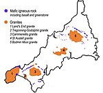 Ligging van Bodmin Moor
 -
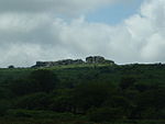
 Rough Tor
 -
 Siblyback Lake
 -
 Stroompje bij Garrow Tor
 -
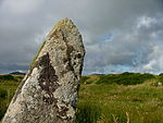 King Arthurs Hall
 -
 Kilmar Tor
 -
 Hawk's Tor
 -
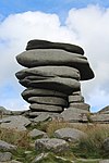 Cheesewring - Uitzondering van granietstenen in de buurt van Minions


Geplaatst op:
31-05-2015
31-05-2015
Dit artikel is een beginnetje over landen & volken. U wordt uitgenodigd om op bewerken te klikken om uw kennis aan dit artikel toe te voegen.
Text is available under the CC BY-SA 4.0 license; additional terms may apply.
Images, videos and audio are available under their respective licenses.
Cover photo is available under {{::mainImage.info.license.name || 'Unknown'}} license.
Cover photo is available under {{::mainImage.info.license.name || 'Unknown'}} license.
Credit:
(see original file).
