Bestand:Upper West Ghana districts.png
Grootte van deze voorvertoning: 776 × 600 pixels. Andere resoluties: 311 × 240 pixels | 621 × 480 pixels | 994 × 768 pixels | 1.056 × 816 pixels.
Oorspronkelijk bestand (1.056 × 816 pixels, bestandsgrootte: 35 kB, MIME-type: image/png)
Dit is een bestand van Wikimedia Commons.
Onderstaande beschrijving komt van de beschrijving van het bestand daar.
Onderstaande beschrijving komt van de beschrijving van het bestand daar.
Beschrijving
| Beschrijving |
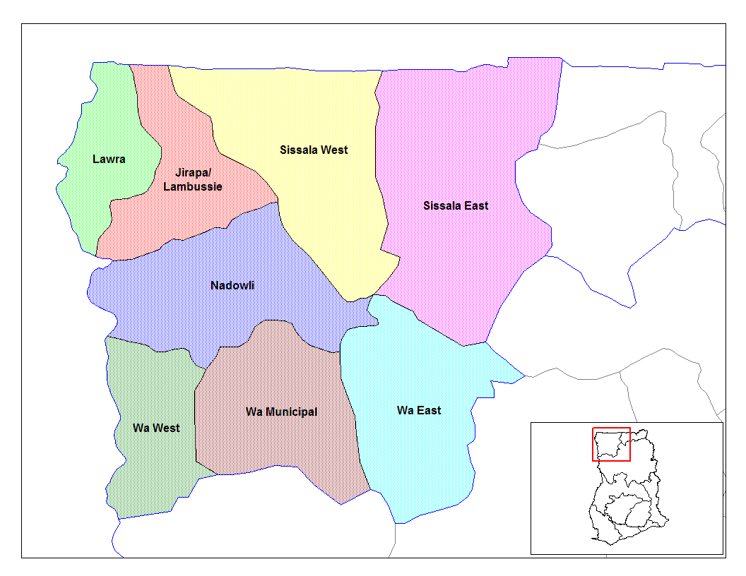
English: Map of the districts of the Upper East region of Ghana. Created by Rarelibra for public domain use. Created using MapInfo Professional v7.5 and various mapping resources. |
| Datum | 28 juni 2006 (originele uploaddatum) |
| Bron | Eigen werk |
| Auteur | User:Rarelibra |
Licentie
| Ik, de auteursrechthebbende van dit werk, geef dit werk vrij in het publieke domein. Dit is wereldwijd van toepassing. In sommige landen is dit wettelijk niet mogelijk; in die gevallen geldt: Ik sta iedereen toe dit werk voor eender welk doel te gebruiken, zonder enige voorwaarden, tenzij zulke voorwaarden door de wet worden voorgeschreven. |
Oorspronkelijk uploadlogboek
- (del) (cur) 07:52, 5 March 2006 . . Rarelibra (Talk | contribs) . . 1056x816 (33,321 bytes) (Map of the districts of the Upper East region of Ghana. Created by Rarelibra for public domain use. Created using MapInfo Professional v7.5 and various mapping resources.)
Bestandsgeschiedenis
Klik op een datum/tijd om het bestand te zien zoals het destijds was.
| Datum/tijd | Miniatuur | Afmetingen | Gebruiker | Opmerking | |
|---|---|---|---|---|---|
| huidige versie | 28 jun 2006 21:06 | | 1.056 × 816 (35 kB) | Ahanta | from en:districts of ghana Map of the districts of the Upper East region of Ghana. Created by Rarelibra for public domain use. Created using MapInfo Professional v7.5 and various mapping resources. [edit] I, the creator of this work, hereby release it in |
Bestandsgebruik
Dit bestand wordt op de volgende 2 pagina's gebruikt:
Globaal bestandsgebruik
De volgende andere wiki's gebruiken dit bestand:
- Gebruikt op ca.wikipedia.org
- Gebruikt op dag.wikipedia.org
- Gebruikt op de.wikipedia.org
- Gebruikt op en.wikipedia.org
- Gebruikt op es.wikipedia.org
- Gebruikt op fa.wikipedia.org
- Gebruikt op fr.wikipedia.org
- Gebruikt op gpe.wikipedia.org
- Gebruikt op ha.wikipedia.org
- Gebruikt op ig.wikipedia.org
- Gebruikt op it.wikipedia.org
- Gebruikt op ja.wikipedia.org
- Gebruikt op ko.wikipedia.org
- Gebruikt op la.wikipedia.org
- Gebruikt op pl.wikipedia.org
- Gebruikt op pt.wikipedia.org
- Gebruikt op ro.wikipedia.org
- Gebruikt op sw.wikipedia.org
- Gebruikt op tr.wikipedia.org
Globaal gebruik van dit bestand bekijken.
Text is available under the CC BY-SA 4.0 license; additional terms may apply.
Images, videos and audio are available under their respective licenses.
Cover photo is available under {{::mainImage.info.license.name || 'Unknown'}} license.
Cover photo is available under {{::mainImage.info.license.name || 'Unknown'}} license.
Credit:
(see original file).
