Bestand:Banggai Islands Topography.png
Grootte van deze voorvertoning: 638 × 600 pixels. Andere resoluties: 255 × 240 pixels | 511 × 480 pixels | 817 × 768 pixels | 1.089 × 1.024 pixels | 1.999 × 1.879 pixels.
Oorspronkelijk bestand (1.999 × 1.879 pixels, bestandsgrootte: 1,25 MB, MIME-type: image/png)
Dit is een bestand van Wikimedia Commons.
Onderstaande beschrijving komt van de beschrijving van het bestand daar.
Onderstaande beschrijving komt van de beschrijving van het bestand daar.
Beschrijving
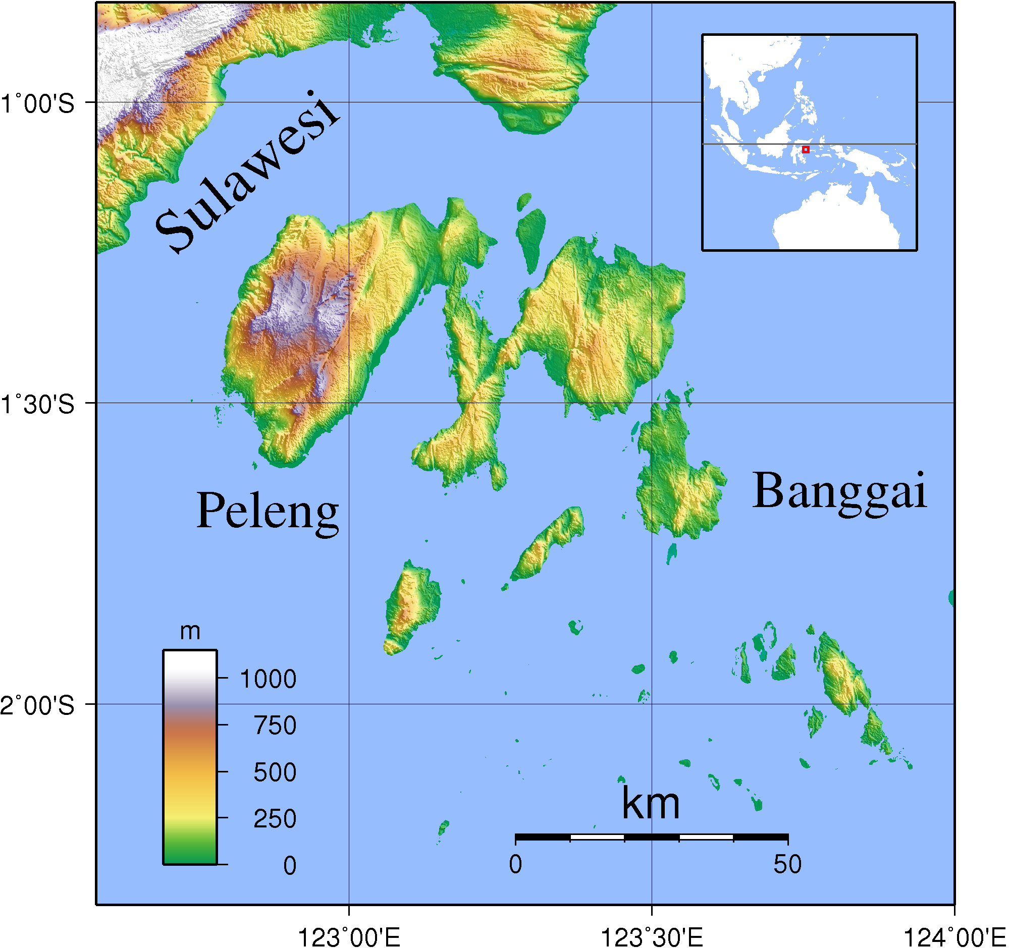
| Beschrijving | Topographic map of Banggai Islands, Indonesia. Created with GMT from SRTM data. The coastline data is pretty bad here, but since SRTM data of the region has a lot of spurious land masses, I had to use it nevertheless. |
| Datum | |
| Bron | Eigen werk |
| Auteur | Sadalmelik |
Licentie
Ik, de auteursrechthebbende van dit werk, maak het hierbij onder de volgende licenties beschikbaar:

|
Toestemming wordt verleend voor het kopiëren, verspreiden en/of wijzigen van dit document onder de voorwaarden van de GNU-licentie voor vrije documentatie, versie 1.2 of enige latere versie als gepubliceerd door de Free Software Foundation; zonder Invariant Sections, zonder Front-Cover Texts, en zonder Back-Cover Texts. Een kopie van de licentie is opgenomen in de sectie GNU-licentie voor vrije documentatie. |
Dit bestand is gelicenseerd onder de Creative Commons-licenties Naamsvermelding-Gelijk delen 3.0 Unported, 2.5 Algemeen, 2.0 Algemeen en 1.0 Algemeen.
- De gebruiker mag:
- Delen – het werk kopiëren, verspreiden en doorgeven
- Remixen – afgeleide werken maken
- Onder de volgende voorwaarden:
- naamsvermelding – U moet op een gepaste manier aan naamsvermelding doen, een link naar de licentie geven, en aangeven of er wijzigingen in het werk zijn aangebracht. U mag dit op elke redelijke manier doen, maar niet zodanig dat de indruk wordt gewekt dat de licentiegever instemt met uw werk of uw gebruik van zijn werk.
- Gelijk delen – Als u het werk heeft geremixt, veranderd, of erop heeft voortgebouwd, moet u het gewijzigde materiaal verspreiden onder dezelfde licentie als het oorspronkelijke werk, of een daarmee compatibele licentie.
U mag zelf één van de licenties kiezen.
Bestandsgeschiedenis
Klik op een datum/tijd om het bestand te zien zoals het destijds was.
| Datum/tijd | Miniatuur | Afmetingen | Gebruiker | Opmerking | |
|---|---|---|---|---|---|
| huidige versie | 11 sep 2007 23:17 | | 1.999 × 1.879 (1,25 MB) | Sadalmelik | ((Information |Description=Topographic map of Banggai Islands, Indonesia. Created with GMT from SRTM data. The coastline data is pretty bad here, but since SRTM data of the region has a lot of spurious land masses, I had to use it nevertheless. |Source=s |
Bestandsgebruik
Dit bestand wordt op de volgende 3 pagina's gebruikt:
Globaal bestandsgebruik
De volgende andere wiki's gebruiken dit bestand:
- Gebruikt op ar.wikipedia.org
- Gebruikt op arz.wikipedia.org
- Gebruikt op ceb.wikipedia.org
- Gebruikt op de.wikipedia.org
- Gebruikt op en.wikipedia.org
- Gebruikt op es.wikipedia.org
- Gebruikt op eu.wikipedia.org
- Gebruikt op fi.wikipedia.org
- Gebruikt op fr.wikipedia.org
- Gebruikt op gl.wikipedia.org
- Gebruikt op id.wikipedia.org
- Gebruikt op it.wikipedia.org
- Gebruikt op ja.wikipedia.org
- Gebruikt op lt.wikipedia.org
- Gebruikt op lv.wikipedia.org
- Gebruikt op mrj.wikipedia.org
- Gebruikt op pl.wikipedia.org
- Gebruikt op pt.wikipedia.org
- Gebruikt op ru.wikipedia.org
- Gebruikt op sv.wikipedia.org
- Gebruikt op ta.wikipedia.org
- Gebruikt op uk.wikipedia.org
- Gebruikt op vi.wikipedia.org
- Gebruikt op www.wikidata.org
- Gebruikt op wuu.wikipedia.org
- Gebruikt op zh-yue.wikipedia.org
- Gebruikt op zh.wikipedia.org
Globaal gebruik van dit bestand bekijken.
Text is available under the CC BY-SA 4.0 license; additional terms may apply.
Images, videos and audio are available under their respective licenses.
Cover photo is available under {{::mainImage.info.license.name || 'Unknown'}} license.
Cover photo is available under {{::mainImage.info.license.name || 'Unknown'}} license.
Credit:
(see original file).
