फेवाताल
| फेवाताल | |
|---|---|
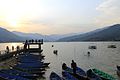
_Sunset_View_2158.JPG) सुर्यास्तको समय फेवाताल को दृश्य, पोखरा | |
| रहेको स्थान | कास्की जिल्ला |
| भौगोलिक निर्देशांक | २८°१२′५१″उ॰ ८३°५६′५०″पू॰ / २८.२१४१७°N ८३.९४७२२°Eनिर्देशाङ्कहरू: २८°१२′५१″उ॰ ८३°५६′५०″पू॰ / २८.२१४१७°N ८३.९४७२२°E |
| तालको प्रकार | सफा पानी |
| अन्तर्वाह | हर्पन तथा फिर्के खोला |
| सिंचित क्षेत्रफल | १२२.५३ वर्ग किलोमिटर |
| सिंचित क्षेत्र | |
| अधिकतम लम्बाई | ४ किलोमिटर |
| अधिकतम चौडाई | २ किलोमिटर |
| सतहको क्षेत्रफल | ५.२३ वर्ग किलोमिटर |
| औसत गहिराई | ८.६ मिटर |
| अधिक गहिराई | २४ मिटर |
| पानीको आयतन | ०.०४६ घन किलोमिटर |
| सतहको उचाई | ७४२ मिटर |
| जम्ने | जम्दैन |
| टापूहरू | तालबाराही |
| बसोबास | पोखरा, सराङकोट, कास्कीकोट, ढिकुरपोखरी |
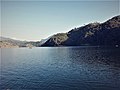
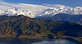
फेवाताल नेपालको (पुर्ववत् पश्चिमाञ्चल विकास क्षेत्रको गण्डकी अञ्चल, हाल गण्डकी प्रदेश) कास्की जिल्लामा अवस्थित अत्यन्तै प्रसिद्ध ताल एवम् नेपालको दोश्रो सबैभन्दा ठुलो ताल हो।[१] पोखरा उपत्यकामा रहेको यो ताल आन्तरिक तथा वाह्य पर्यटकहरूमाझ लोकप्रीय छ। 'फेवा' गाउँको छेउमा रहेकाले यो तालको नाम फेवाताल रहन गएको हो। 'वैदाम' गाउँको छेउमा पर्ने हुँदा वैदाम ताल पनि भनिने गरिन्छ। तालको बीचमा 'बराही मन्दिर' रहेको छ।


फेवाताल समुन्द्रको सतहदेखी ७४२ मिटर (२४३४ फिट) को उचाईंमा स्थित रहेको छ। यस तालले लगभग ५.२३ बर्ग किमी (२ बर्ग माइल) क्षेत्रफल ओगटेको छ। यस तालको औषत गहिराइ ८.६ मिटर (२८ फिट) रहेको छ भने अधिकतम् गहिराइ २४ मिटर (७९ फिट) रहेको छ।[२] यस तालको अधिकतम जल क्षमता लगभग ४,३०,००,००० क्यूबिक मिटर (३५,००० एकड फिट) रहेको छ। यस तालको उत्तर दिशामा अन्नपूर्णा शृङ्खला रहेको छ, जुन २८ कि.मि.को दुरीमा छ। यो ताल माछापुच्छ्रे, अन्नपूर्णा र धवलागीरी तथा अन्य पर्वतको टाकुराको प्रतिबिम्बको लागि पनि प्रसिद्ध छ। अहिले तालमा जलकुम्बी झार र विभिन्न ठाउँबाट बगाएर ल्याएका मुढा, दाउरा, कागज आदि देख्न सकिन्छ।
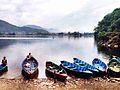
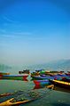
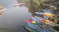
चित्र दिर्घा
[सम्पादन गर्नुहोस्]-
 फेवाताल
 -
 फेवाताल
 -
 सुर्यास्तको समय फेवाताल को दृश्य
 -

-
-

-

-
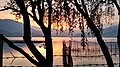 सूर्यास्तको बेलामा फेवाताल
 -
-
 सूर्यास्तको बेलामा फेवाताल
 -

-
-
-
-


सन्दर्भ सामग्रीहरू
[सम्पादन गर्नुहोस्]- ↑ Aryal, Vijay (२८ अक्टोबर – २ नोभेम्बर २००७), "फेवातालको क्षेत्रफल", Proceedings of Taal 2007: The 12th World Lake Conference, Jaipur, India (International Lake Environment Committee): 2292–2299।
- ↑ Rai, Ash Kumar (२०००), "फेवाताल र यसको विविधता", Limnology 1: 81–89, डिओआई:10.1007/s102010070014।[स्थायी मृत कडी]
यो पनि हेर्नुहोस
[सम्पादन गर्नुहोस्]नेपालको जलसम्पदा | ||||||||||||
|---|---|---|---|---|---|---|---|---|---|---|---|---|
| नदीहरू |
| |||||||||||
| तालहरू | ||||||||||||
| हिमनदीहरू |
| |||||||||||
| हिमप्रपात | ||||||||||||
| बाँध | ||||||||||||
| सम्बन्धित विषयहरू | ||||||||||||
बाह्य कडीहरू
[सम्पादन गर्नुहोस्]
Text is available under the CC BY-SA 4.0 license; additional terms may apply.
Images, videos and audio are available under their respective licenses.
