For faster navigation, this Iframe is preloading the Wikiwand page for चित्र:Egypt relief location map.jpg.

चित्र:Egypt relief location map.jpg
मूल फाइल(१,०५५ × ९७३ पिक्सेलहरू, फाइल आकार: ४५९ किलोबाइटहरू, MIME प्रकार: image/jpeg)

सारांश

वर्णन
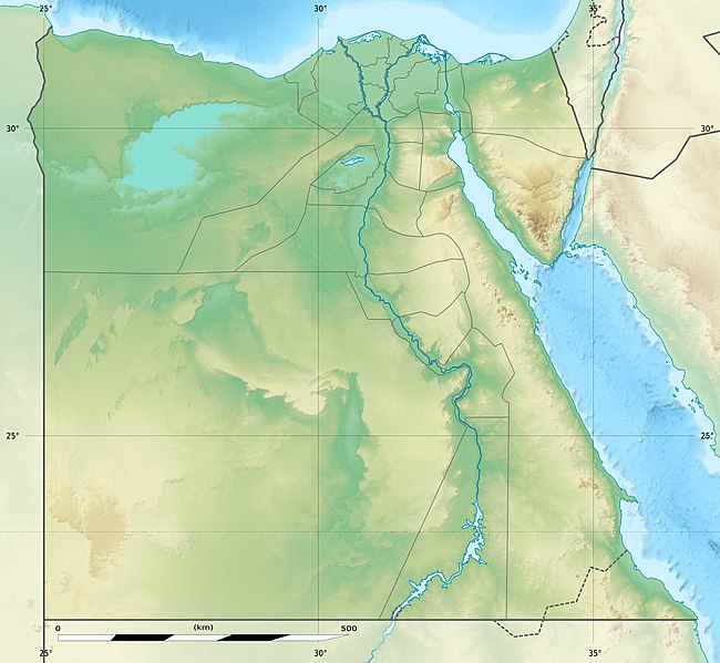
Deutsch: Relief Positionskarte von Ägypten
English: Physical location map of Egypt.
Français : Carte physique vierge destinée à la géolocalisation de l'Égypte telle que depuis le 14 avril 2011 suite à la dissolution des gouvernorats du 6 Octobre et de Helwan.

Topographic scale: 1:4,932,000 (precision: 1,233 m)
Equirectangular projection, WGS84 datum

  • Standard meridian: 030° 45' E
  • Central parallel: 26° 42' N

Geographic limits of the map:

  • Top: 32° 06' N
  • Bottom: 21° 18' N
  • Left: 024° 12' E
  • Right: 037° 18' E
मिति 2010-03, updated 2014-06
स्रोत

Topographic background map: Own work

  • Source of data: SRTM30 Plus
All other data taken from File:Egypt_location_map.svg created by NordNordWest under GFDL/CC-BY-SA 3.0
लेखक Eric Gaba (Sting - fr:Sting) and NordNordWest
अनुमति
(यो फाइल पुनप्रयोग गर्न)
Attribution and Share-Alike required
अरु संस्करणहरू

Derivative works of this file:  Lower Egypt ancient nomes position map.jpg

Camera location२६° ४२′ ००″ N, ३०° ४५′ ००″ E Kartographer map based on OpenStreetMap.View this and other nearby images on: OpenStreetMapinfo
Kartenwerkstatt
This map has been made or improved in the German Kartenwerkstatt (Map Lab). You can propose maps to improve as well.

अनुज्ञा प्राप्त गर्दै

I, the copyright holder of this work, hereby publish it under the following licenses:
GNU head यस दस्तावेजलाई स्वतन्त्र सफ्टवायर फाउन्डेसन द्वारा प्रकाशित जी॰एन॰यू फ्रि डक्यूमेन्टेशन लाइसेन्स को संस्करण 1.2 वा नयाँ (बिना कुनै इन्वेरियेन्ट अनुभाग र पछिल्लो वा पहिलो आवरणका पाठका) को अन्तर्गत कपी, वितरित एवं/अथवा परिवर्तित गर्ने अनुमति प्रदान गरिन्छ । यस लाइसेन्सको एक प्रति जी॰एन॰यू फ्रि डक्यूमेन्टेशन लाइसेन्स नामक अनुभागमा शामिल छ ।
w:en:Creative Commons
एट्रिब्युसन शेयर अलाइक
यो फाइल क्रिएटिभ कमन्स एट्रिब्युसन-सेयर एलाइक ३.० अनपोर्टेड लाइसेन्स अनुसारको अनुमति प्राप्त छ।
तपाईं स्वतन्त्र हुनुहुन्छ :
  • साझेदारी गर्नुहाेस् – रचनालाई कपी, वितरित तथा संचारित गर्नको लागि
  • रिमिक्स गर्नको लागि – काम अनुकूलित गर्नको लागि
निम्नलिखित कारणहरूको अन्तर्गत:
  • एट्रिब्युसन – तपाईंले रचनाको श्रेय अनुमतिपत्रकर्ता अथवा लेखकले बताएको माध्यमले दिनु पर्नेछ (तर यस प्रकार हैन, जसमा लागोस् की उ तपाईंलाई अथवा तपाईंको रचनाको प्रयोगलाई समर्थन गर्छन्)।
  • शेयर अलाइक – यदि तपाई यस रचनामा कुनै परिवर्तन अथवा संसोधन गर्नुहुन्छ या यसमा आधारित केही रचना गर्नुहुन्छ भने तपाई निष्कर्ष स्वरूप बनेको रचनालाई मात्र यहाँ अथवा यसको समान कुनै अनिमति पत्र अन्तर्गत वितरित गर्न सक्नुहुन्छ।
तपाईँ आफ्नो मनपर्ने इजाजतपत्र रोज्न सक्नुहुन्छ ।

Captions

Add a one-line explanation of what this file represents

Items portrayed in this file

जनाउँछ

copyright status अङ्ग्रेजी

copyrighted अङ्ग्रेजी

copyright license अङ्ग्रेजी

coordinates of the point of view अङ्ग्रेजी

26°42'0.000"N, 30°45'0.000"E

media type अङ्ग्रेजी

image/jpeg

फाइल इतिहास

मिति/समय मा क्लिक गरेर त्यससमयमा यो फाइल कस्तो थियो भनेर हेर्न सकिन्छ ।

मिति/समयछोटो चित्रआकारहरूप्रयोगकर्ताटिप्पणी
हालको१९:४६, १८ अगस्ट २०१७छोटो चित्र १९:४६, १८ अगस्ट २०१७ संस्करणको रुपमा१,०५५×९७३ (४५९ किलोबाइटहरू)MélomèneAccording with [https://en.wikipedia.org/wiki/Hala%27ib_Triangle]
०१:३८, १४ जुन २०१४छोटो चित्र ०१:३८, १४ जुन २०१४ संस्करणको रुपमा१,०५५×९७३ (४५० किलोबाइटहरू)StingColor profile
०१:२८, १४ जुन २०१४छोटो चित्र ०१:२८, १४ जुन २०१४ संस्करणको रुपमा१,०५५×९७३ (४२२ किलोबाइटहरू)StingUpdated Governorates borders shape
१९:४४, १८ अप्रिल २०११छोटो चित्र १९:४४, १८ अप्रिल २०११ संस्करणको रुपमा१,०५५×९७५ (४१५ किलोबाइटहरू)StingUpdated after Governorats dissolution
१९:१५, १९ जुलाई २०१०छोटो चित्र १९:१५, १९ जुलाई २०१० संस्करणको रुपमा१,०५५×९७३ (४५१ किलोबाइटहरू)StingColor profile
००:४९, ८ मार्च २०१०छोटो चित्र ००:४९, ८ मार्च २०१० संस्करणको रुपमा१,०५५×९७३ (४५० किलोबाइटहरू)Sting== ((int:filedesc)) == ((Location|26|42|00|N|30|45|00|E|scale:10000000)) <br/> ((Information |Description= ((de|Relief Positionskarte von Ägypten)) ((en|Physical location map of Egypt.)) ((fr|Carte physique vierge de l'[[:f

फाइल प्रयोग

यस फाइलमा निम्न 2 पृष्ठहरू जोडिन्छन्:

विश्वव्यापी फाइल प्रयोग

निम्न अन्य विकिहरूमा यस फाइलको प्रयोग:

यस फाइलको विश्वव्यापी उपयोगको अधिक जानकारी हेर्नुहोस् ।

मेटाडाटा

{{bottomLinkPreText}} {{bottomLinkText}}
चित्र:Egypt relief location map.jpg
Listen to this article

This browser is not supported by Wikiwand :(
Wikiwand requires a browser with modern capabilities in order to provide you with the best reading experience.
Please download and use one of the following browsers:

This article was just edited, click to reload
This article has been deleted on Wikipedia (Why?)

Back to homepage

Please click Add in the dialog above
Please click Allow in the top-left corner,
then click Install Now in the dialog
Please click Open in the download dialog,
then click Install
Please click the "Downloads" icon in the Safari toolbar, open the first download in the list,
then click Install
{{::$root.activation.text}}

Install Wikiwand

Install on Chrome Install on Firefox
Don't forget to rate us

Tell your friends about Wikiwand!

Gmail Facebook Twitter Link

Enjoying Wikiwand?

Tell your friends and spread the love:
Share on Gmail Share on Facebook Share on Twitter Share on Buffer

Our magic isn't perfect

You can help our automatic cover photo selection by reporting an unsuitable photo.

This photo is visually disturbing This photo is not a good choice

Thank you for helping!


Your input will affect cover photo selection, along with input from other users.

X

Get ready for Wikiwand 2.0 🎉! the new version arrives on September 1st! Don't want to wait?