For faster navigation, this Iframe is preloading the Wikiwand page for Sloveniën.

Sloveniën

Republika Slovenija
Vlagge van Sloveniën
Woapn van Sloveniën
Woapn van Sloveniën
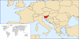
Kaarte van Sloveniën
Informasie
Sproaken Sloveens
Heufdstad Ljubljana
Regeringsvörm Republiek
Geleuf Rooms-katteliek (84%)
Laand en inwonners
Oppervlakte
- Water
20.273 km²
0,6%
Inwonners
- Dichtheid
2.040.788 (2009)
101 inw./km²
Koordinaten 46° 0′ N, 14° 30′ O

Koördinaoten: 46° N, 15° O

Oaverig
Volksleed Zdravljica
Munteenheid euro (EUR)
Tiedzone +1
Nasjonalen feestdag 25 juni (Dag van de Soevereiniteit)
Web | Kode | Tel. .si | SVN | 386

Sloveniën (Sloveens: Slovenija), is n laand in Mildn-Uropa en t is lid van de Uropese Unie. t Laand, ne republiek, greanst in t westn an Italiën, in t noordn an Oostnriek, in t oostn an Hongaarnlaand en in t zuudn an Krowatiën. De heufdstad is Ljubljana. t Laand hef ne öppervlakte van 20.151 veerkaante kilometer en t tealt 2 miljoen inwonners. Dat gef ne bevolkingsdichtheid van 100 inwonners/km².

De officiële taal is Sloveens. t Grootste deel van de Sloveenn is rooms (84%).

Bestuurlike indeling

[bewark | bronkode bewarken]

Statistische regio's

[bewark | bronkode bewarken]
  • Pomurska
  • Podravska
  • Koroška
  • Savinjska
  • Zasavska
  • Spodnjeposavska
  • Jugovzhodna Slovenija
  • Osrednjeslovenska
  • Gorenjska
  • Notranjskokraška
  • Goriška
  • Obalnokraška

Historische regio's

[bewark | bronkode bewarken]
  • 1: Primorska (Küstenland)
  • 2: Kranjska (Krain)
    • 2a: Gorenjska (Oberkrain)
    • 2b: Notranjska (Innerkrain)
    • 2c: Dolenjska (Unterkrain)
  • 3: Koroška (Karinthië)
  • 4: Štajerska (Stiermarken)
  • 5: Prekmurje
  • De elf stadsgemeantn:
    • Celje
    • Koper
    • Kranj
    • Ljubljana (heufdstad)
    • Maribor
    • Murska Sobota
    • Nova Gorica
    • Novo mesto
    • Ptuj
    • Slovenj Gradec
    • Velenje
  • Andere steedn:
    • Ajdovščina
    • Bled
    • Domžale
    • Ilirska Bistrica
    • Izola
    • Jesenice
    • Kamnik
    • Kobarid
    • Kočevje
    • Krško
    • Metlika
    • Piran
    • Postojna
    • Slovenska Bistrica
    • Slovenske Konjice
    • Šentjur pri Celju
    • Škofja Loka
    • Tolmin
    • Trbovlje
    • Vipava
    • Žalec
    • Zagorje ob Savi

Oetgoande verbeendingn

[bewark | bronkode bewarken]


Wikimedia Commons Commons: Sloveniën - plaatjes, filmkes en/of gelüüdsbestanden.
{{bottomLinkPreText}} {{bottomLinkText}}
Sloveniën
Listen to this article

This browser is not supported by Wikiwand :(
Wikiwand requires a browser with modern capabilities in order to provide you with the best reading experience.
Please download and use one of the following browsers:

This article was just edited, click to reload
This article has been deleted on Wikipedia (Why?)

Back to homepage

Please click Add in the dialog above
Please click Allow in the top-left corner,
then click Install Now in the dialog
Please click Open in the download dialog,
then click Install
Please click the "Downloads" icon in the Safari toolbar, open the first download in the list,
then click Install
{{::$root.activation.text}}

Install Wikiwand

Install on Chrome Install on Firefox
Don't forget to rate us

Tell your friends about Wikiwand!

Gmail Facebook Twitter Link

Enjoying Wikiwand?

Tell your friends and spread the love:
Share on Gmail Share on Facebook Share on Twitter Share on Buffer

Our magic isn't perfect

You can help our automatic cover photo selection by reporting an unsuitable photo.

This photo is visually disturbing This photo is not a good choice

Thank you for helping!


Your input will affect cover photo selection, along with input from other users.

X

Get ready for Wikiwand 2.0 🎉! the new version arrives on September 1st! Don't want to wait?