پرونده:Map of the Provinces of Argentina.png
این پیش-پیش سِراق هدائن ِقایده: ۳۶۲ × ۵۹۹ پیکسل. دیگه کیفیتون: ۱۴۵ × ۲۴۰ پیکسل | ۵۶۶ × ۹۳۶ پیکسل.
اصلی پرونده (۵۶۶ × ۹۳۶ پـیـکـسهل, فـایـل گـأتـی: ۳۸ کیلوبایت, MIME مـونـد: image/png)
|
|
این پرونده ویکیتلمبار دله دَره. ونه دلهی بنویشتهئون (مازرونی) ره اینجه سِراق دنه. |
salta
گزارش
| توضیح |
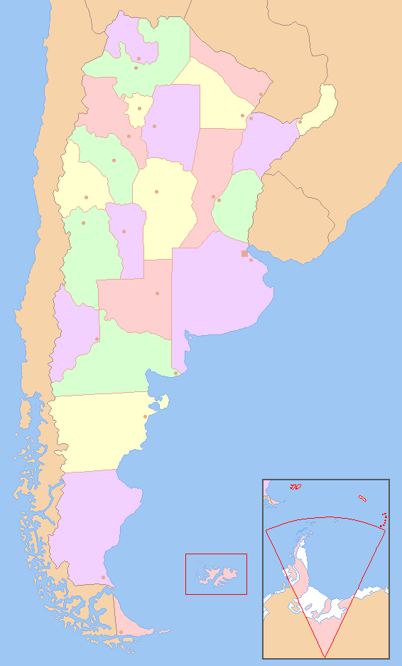
English: Colored map of the Argentine Provinces. The territories marked in red are not under a Argentine control.
Español: Carta coloreada de las provincias de la República Argentina. Los territorios en rojo no se encuentran bajo el control argentino. |
|||
| تاریخ | 14 de diciembre | |||
| منبع | شه کار based on File:Argentina - Político.png | |||
| سازنده | Dexxter | |||
| دیگر نسخهها |
|


اجازهنومه
من، صاحب حقوق قانونی این اثر، به این وسیله این اثر را تحث اجازهنامهٔ ذیل منتشر میکنم:

|
کپی، پخش یا تغییر ِاجازه این سند وسّه تحت شرایط گنویِ آزاد مستندات ِمجوز، نسخهٔ ۱٫۲ یا هر نسخهٔ بعدتری که آزاد نرمافزارون بنیاد باوّه، منتشر بیه؛ بدون بخشهای نامتغیر، متون روی جلد، و متون پشت جلد، هدائه وانه. اتا کپی مجوز جه گنویِ آزاد مستندات ِمجوز ِبخش دله ضمیمه بیه. |
| این پرونده کریتیو کامانز اجازهنومه جه Attribution-Share Alike 3.0 سازگار نییه و منتشر بیه. | ||
| ||
| این برچسب مجوز بهعنوان بخشی از روزآمدسازی مجوز GFDL، به این پرونده افزوده شد. |
فایل تاریخچه
تاریخ/زمونها سَر کلیک هاکنین تا اون گدِر ِنسخه ره هارشین.
| تاریخ/زمون | انگوسگتی | ابعاد | کارور | توضیح | |
|---|---|---|---|---|---|
| إسا | ۱۴ دسامبر ۲۰۰۸، ساعت ۰۶:۵۲ | | ۵۶۶ در ۹۳۶ (۳۸ کیلوبایت) | Dexxter | ((Information |Description=((en|1=Colored map of the Argentine Provinces. The territories marked in red are not under a Argentine control.)) ((es|1=Carta coloreada de las provincias de la República Argentina. Los territorios en rojo no se encuentran bajo |
پروندهی استفاده
این 2 صفحهئون لینک هِدانه این فایل ره:
پروندهیِ گِردِ استفادهئون
این ویکیون هم این پرونده جه استفاده کانّه:
- کاربرد eo.wikipedia.org دله
- کاربرد es.wikipedia.org دله
- کاربرد eu.wikipedia.org دله
- کاربرد fa.wikipedia.org دله
- کاربرد pnb.wikipedia.org دله
- صوبہ سانتا کروز
- صوبہ توکومان
- صوبہ سانتا فے
- صوبہ سان لوئیس
- صوبہ سان جوآن
- صوبہ سالتا
- صوبہ ریو نیگرو
- صوبہ نیوکوئین
- صوبہ میسیؤنس
- صوبہ میندوزا
- صوبہ لا ریؤجا
- صوبہ لا پامپا
- صوبہ جوجوئے
- صوبہ فارموسا
- صوبہ اینترے ریؤس
- صوبہ کوریئنتس
- صوبہ کاردوبا
- صوبہ چوبوت
- صوبہ چاکو
- صوبہ کاتامارکا
- بیونس آئرس خودمختار شہر
- صوبہ بیونس آئرس
- کاردوبا
- پارانا (ارجنٹائن)
- لا پلاتا
- سان میگوئیل دی توکومان
- سان سلوادور دی جوجوئے
- ویدما
- سان جوآن
- سان لوئیس
- سانتا فے
- ریو گالیگوس
- فارموسا (ارجنٹائن)
- لا ریؤجا
- سانتا روزا
- پوساداس
- میندوزا
- نیوکوئن
- ریسیستینا
- راوسون
- سان فرناندو دیل ویلا دی کاتامارکا
- کوریئنتس
سراسری استفاده ره این پرونده جه سٮراق هاده.
Text is available under the CC BY-SA 4.0 license; additional terms may apply.
Images, videos and audio are available under their respective licenses.
Cover photo is available under {{::mainImage.info.license.name || 'Unknown'}} license.
Cover photo is available under {{::mainImage.info.license.name || 'Unknown'}} license.
Credit:
(see original file).
