ဖိုင်:Troas.png
Troas.png (၅၂၀ × ၅၃၉ pixels, ဖိုင်အရွယ်အစား - ၁၁၃ KB, MIME အမျိုးအစား image/png)
| ဤဖိုင်သည် Wikimedia Commons မှဖြစ်ပြီး အခြားပရောဂျက်များတွင် သုံးကောင်းသုံးလိမ့်မည်။ ယင်း၏ ဖိုင်အကြောင်းစာမျက်နှာ တွင် ဖော်ပြထားချက်ကို အောက်တွင် ပြထားသည်။ Commons သည် မူပိုင်ခွင့်လွတ်လပ်သော မီဒီယာဖိုင်များ သိုလှောင်ထားရာ နေရာ ဖြစ်သည်။ သင်လည်း ပါဝင်ကူညီနိုင်ပါသည်။ |
အကျဉ်းချုပ်
| ဖော်ပြချက် |
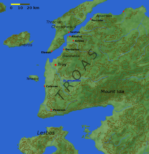
Deutsch: Landkarte der Troas
English: Map of the Troad, including the site of Troy. Note that the modern coastline has been altered to show a bay at the mouth of Scamander where the Greek ships would have been.
Nederlands: ligging en omgeving van Troje |
| ရက်စွဲ | ၄ ဒီဇင်ဘာ ၂၀၀၄ (original upload date) |
| ရင်းမြစ် | Transferred from en.wikipedia to Commons. |
| စာရေးသူ |
Dbachmann at အင်္ဂလိပ် ဝီကီပီးဒီးယား Later versions were uploaded by Joy at en.wikipedia. |
| အခြား ဗားရှင်းများ |
Derivative works of this file: Ancient edremit gulf.jpg
|


|
File:Troas.svg is a vector version of this file. It should be used in place of this PNG file.
File:Troas.png → File:Troas.svg
For more information, see Help:SVG. |
 |
လိုင်စင်သတ်မှတ်ခြင်း

|
ဤစာတမ်းကို GNU Free Documentation License, ဗားရှင်း ၁.၂ သို့မဟုတ် Free Software Foundation မှ ဖြန့်ချီထားသော မည်သည့်ယခင်ဗားရှင်းတစ်ခုခုအောက်တွင် Invariant Sections, Front-Cover Texts နှင့် Back-Cover Texts များမပါဝင်ဘဲ ကူးယူခြင်း၊ ဖြန့်ချီခြင်း နှင့်/သို့မဟုတ် ပြင်ဆင်ပြောင်းလဲနိုင်ရန် ခွင့်ပြုသည်။ လိုင်စင်မူပွားကို GNU Free Documentation License ခေါင်းစဉ်အောက်တွင် ထည့်သွင်းထားသည်။ |
| ဤဖိုင်ကို Creative Commons Attribution-Share Alike 3.0 Unported လိုင်စင်ဖြင့် သတ်မှတ်ထားသည်။ | ||
| ||
| This licensing tag was added to this file as part of the GFDL licensing update. |
|
NOTE: "subject to disclaimers" below may not actually apply, this was tagged with ((GFDL-user-en)), and after May 2007, en:Template:GFDL-self did not require disclaimers. Please check the image description page on the English Wikipedia (or, if it has been deleted, ask an English Wikipedia administrator). See Wikipedia:GFDL standardization for details. | ||
Joy from en.wikipedia.org၊ ဤလုပ်ဆောင်ချက်၏ မူပိုင်ခွင့်ပိုင်ရှင်အနေဖြင့် ဤနေရာမှ အောက်ပါလိုင်စင်အောက်တွင် ထုတ်လွှင့်ပါသည်:
| ||
|
Note: This tag should not be used. For images that were released on the English Wikipedia using either GFDL or GFDL-self with disclaimers, use ((GFDL-user-en-with-disclaimers)). For images without disclaimers please use ((GFDL-user-en-no-disclaimers)) instead. If you are the copyright holder of files that were released on Wikipedia, please consider removing the disclaimers. |
မူရင်းတင်ထားသောမှတ်တမ်း
- 2005-03-06 14:15 Joy 520×539×8 (115389 bytes) reduced palette to 256 colors to halve the file size with negligible visual impact (reducing to 150 colors drops some 15KB more but it's not worth it)
- 2004-12-15 13:50 Dbachmann 520×539×8 (286334 bytes) scale
- 2004-12-04 15:03 Dbachmann 447×475×8 (193411 bytes) update position of Troy
- 2004-12-04 13:34 Dbachmann 450×489×8 (203976 bytes) '
- 2004-12-04 12:43 Dbachmann 470×519×8 (228694 bytes) ((GFDL))
ဖိုင်မှတ်တမ်း
ဖိုင်ကို ယင်းနေ့စွဲ အတိုင်း မြင်နိုင်ရန် နေ့စွဲ/အချိန် တစ်ခုခုပေါ်တွင် ကလစ်နှိပ်ပါ။
| နေ့စွဲ/အချိန် | နမူနာပုံငယ် | မှတ်တမ်း ဒိုင်မန်းရှင်းများ | အသုံးပြုသူ | မှတ်ချက် | |
|---|---|---|---|---|---|
| ကာလပေါ် | ၀၅:၃၇၊ ၁၁ ဇန်နဝါရီ ၂၀၀၆ | | ၅၂၀ × ၅၃၉ (၁၁၃ KB) | Olliminatore | from en: |
ဖိုင်သုံးစွဲမှု
အောက်ပါ စာမျက်နှာ သည် ဤဖိုင်ကို အသုံးပြုထားသည်:
ဂလိုဘယ် ဖိုင်သုံးစွဲမှု
အောက်ပါ အခြားဝီကီများတွင် ဤဖိုင်ကို အသုံးပြုထားသည်-
- af.wikipedia.org တွင် အသုံးပြုမှု
- am.wikipedia.org တွင် အသုံးပြုမှု
- ar.wikipedia.org တွင် အသုံးပြုမှု
- arz.wikipedia.org တွင် အသုံးပြုမှု
- azb.wikipedia.org တွင် အသုံးပြုမှု
- az.wikipedia.org တွင် အသုံးပြုမှု
- ba.wikipedia.org တွင် အသုံးပြုမှု
- be.wikipedia.org တွင် အသုံးပြုမှု
- bg.wikipedia.org တွင် အသုံးပြုမှု
- bn.wikipedia.org တွင် အသုံးပြုမှု
- br.wikipedia.org တွင် အသုံးပြုမှု
- ceb.wikipedia.org တွင် အသုံးပြုမှု
- ce.wikipedia.org တွင် အသုံးပြုမှု
- cs.wikipedia.org တွင် အသုံးပြုမှု
- cy.wikipedia.org တွင် အသုံးပြုမှု
- de.wikipedia.org တွင် အသုံးပြုမှု
- el.wikipedia.org တွင် အသုံးပြုမှု
- en.wikipedia.org တွင် အသုံးပြုမှု
- es.wikipedia.org တွင် အသုံးပြုမှု
- eu.wikipedia.org တွင် အသုံးပြုမှု
- fi.wikipedia.org တွင် အသုံးပြုမှု
- fr.wikipedia.org တွင် အသုံးပြုမှု
- fy.wikipedia.org တွင် အသုံးပြုမှု
- he.wikipedia.org တွင် အသုံးပြုမှု
- hr.wikipedia.org တွင် အသုံးပြုမှု
- hu.wikipedia.org တွင် အသုံးပြုမှု
ဤဖိုင်ကို အခြားနေရာများတွင် အသုံးပြုထားမှုများအား ကြည့်ရှုရန်။
Text is available under the CC BY-SA 4.0 license; additional terms may apply.
Images, videos and audio are available under their respective licenses.
