St Margaret's Road

St Margaret's Road adalah sebuah jalan North Oxford, England.[1]
Lokasi
[sunting | sunting sumber]Jalan berjalan antara Kingston Road di sebelah barat dan Banbury Jalan di timur, menyeberangi Woodstock Road. Di bahagian selatan terdapat Farndon Road di sebelah barat dan Canterbury Road ke timur. Ke utara adalah Polstead Road (barat) dan Rawlinson Road (timur).
Pintu masuk utama St Hugh's College, utara Oxford kolej dan salah satu bekas kolej wanita, adalah di sebelah selatan jalan. Alasan Kolej menghulurkan sepanjang jalan dari Woodstock Jalan untuk Banbury Road.
Di sudut timur laut dengan Kingston Road di hujung barat adalah paroki gereja St Margaret.[2][3]
Green Templeton College mempunyai penginapan di beberapa buah rumah di St Margaret's Road.[4]
Sejarah
[sunting | sunting sumber]Rackham Lane, yang kemudiannya menjadi Jalan St Margaret, telah dibentangkan pada tahun 1879 sebagai sebahagian daripada estet Norham Manor.[perlu rujukan] Menurut Henry Taunt, bahagian jalan antara Banbury Road dan Jalan Woodstock dipanggil Gallows-Baulk Road. Apabila jalan yang bertambah baik, tinggalan beberapa orang yang telah digantung ditemui.
Rumah-rumah di Jalan St Margaret kebanyakannya direka oleh William Wilkinson dan Harry Wilkinson Moore dalam perkongsian.[1] Rumah-rumah ini telah dibina antara 1879 dan 1886.[5] The main buildings of St Hugh's College are by Herbert Tudor Buckland and William Haywood, dating from 1914–16 and built in a neo-Georgian style.
Galeri
[sunting | sunting sumber]-
 Lihat barat di sepanjang St Margaret's Road dari simpang dengan Woodstock Road.
 -
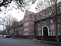 Bangunan-bangunan St Hugh's College di belah selatan St Margaret's Road.
 -
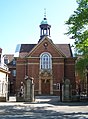 Pintu masuk utama St Hugh's College di St Margaret's Road.


Rujukan
[sunting | sunting sumber]- ^ a b Hinchcliffe, Tanis (1992). North Oxford. New Haven & London: Yale University Press. m/s. 1, 53, 79–81, 85, 121, 236–237. ISBN 0-14-071045-0.
- ^ The Church Building, St Margaret's Church.
- ^ Short History, St Margaret's Church, Oxford.
- ^ St Margaret's Road, Green Templeton College, University of Oxford, UK.
- ^ Sherwood, Jennifer; Pevsner, Nikolaus (1974). The Buildings of England: Oxfordshire. Penguin Books. m/s. 247, 293, 321. ISBN 0-14-071045-0.
Text is available under the CC BY-SA 4.0 license; additional terms may apply.
Images, videos and audio are available under their respective licenses.
