Rhode Island
| Rhode Island | |||||||||||
| |||||||||||
| Bahasa rasmi | De jure: None De facto: English | ||||||||||
| Demonim | Rhode Islander | ||||||||||
| Ibu negeri | Providence | ||||||||||
| Bandar raya terbesar | Providence | ||||||||||
| Keluasan | Kedudukan 50th | ||||||||||
| - Jumlah | 1,545[2] batu persegi (3,140 km²) | ||||||||||
| - Lebar | 37 batu (60 km) | ||||||||||
| - Panjang | 48 batu (77 km) | ||||||||||
| - % air | 32.4 | ||||||||||
| - Latitud | 41° 09' N to 42° 01' N | ||||||||||
| - Longitud | 71° 07' W to 71° 53' W | ||||||||||
| Penduduk | Kedudukan 43rd | ||||||||||
| - Jumlah | 1,053,209 (2009 est.)[3] | ||||||||||
| - Kepadatan | 1,012.3/batu persegi 390.78/km² (2nd) | ||||||||||
| Ketinggian | |||||||||||
| - Titik tertinggi | Jerimoth Hill[4] 812 ft (247 m) | ||||||||||
| - Purata | 200 ft (60 m) | ||||||||||
| - Titik terendah | Atlantic Ocean[4] 0 ft (0 m) | ||||||||||
| Kemasukan ke dalam Kesatuan |
May 29, 1790 (13th) | ||||||||||
| Gabenor | Daniel McKee (D) | ||||||||||
| Leftenan Gabenor | Sabina Matos (D) | ||||||||||
| Senator A.S. | Jack Reed (D) Sheldon Whitehouse (D) | ||||||||||
| Delegasi Dewan A.S. | 1: David Cicilline (D) 2: James Langevin (D) (Senarai) | ||||||||||
| Zon waktu | Eastern: UTC-5/-4 | ||||||||||
| Singkatan | RI US-RI | ||||||||||
| Tapak web | www.ri.gov | ||||||||||
| Nota kaki: * Total area in acres is approximately 776,957 ekar (3,144 km2) | |||||||||||
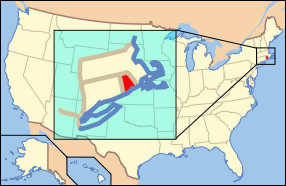
Rhode Island merupakan sebuah negeri di kawasan New England, Amerika Syarikat. Rhode Island merupakan negeri yang terkecil mengikut keluasan di Amerika. Rhode Island bersempadan dengan Connecticut di bahagian barat, Massachusetts di utara dan timur dan mempunyai sempadan pengairan dengan Long Island, New York di barat daya. Rhode Island merupakan negeri pertama antara tiga belas koloni yang mengisytiharkan kemerdekaan daripada British tetapi merupakan negeri terakhir untuk menandatangani Perlembagaan Amerika Syarikat
Rujukan
[sunting | sunting sumber]- ^ RI.gov. "Rhode Island Government : Government". RI.gov. Dicapai pada July 31, 2010.
- ^ http://sos.ri.gov/library/history/facts/
- ^ "Annual Estimates of the Resident Population for the United States, Regions, States, and Puerto Rico: April 1, 2000 to July 1, 2009". United States Census Bureau. Dicapai pada December 23, 2009.
- ^ a b "Elevations and Distances in the United States". U.S Geological Survey. April 29, 2005. Dicapai pada November 7, 2006.
Jika anda melihat rencana yang menggunakan templat ((tunas)) ini, gantikanlah ia dengan templat tunas yang lebih spesifik.
| Negeri | Alabama · Alaska · Arizona · Arkansas · California · Carolina Selatan · Carolina Utara · Colorado · Connecticut · Dakota Selatan · Dakota Utara · Ohio · Delaware · Florida · Georgia · Hawaii · Idaho · Illinois · Indiana · Iowa · Kansas · Kentucky · Louisiana · Maine · Maryland · Massachusetts · Michigan · Minnesota · Mississippi · Missouri · Montana · Nebraska · Nevada · New Hampshire · New Jersey · New Mexico · New York · Oklahoma · Oregon · Pennsylvania · Rhode Island · Tennessee · Texas · Utah · Vermont · Virginia · Virginia Barat · Washington · Wisconsin · Wyoming |
|---|---|
| Daerah persekutuan | Washington, D.C. (Daerah Columbia) |
| Kawasan pulau | |
| Pulau terpencil | |
Text is available under the CC BY-SA 4.0 license; additional terms may apply.
Images, videos and audio are available under their respective licenses.


