For faster navigation, this Iframe is preloading the Wikiwand page for Fail:LocationPolarRegions.png.

Fail:LocationPolarRegions.png
Fail asli(2,759 × 1,404 piksel, saiz fail: 92 KB, jenis MIME: image/png)

Fail ini dari Wikimedia Commons dan mungkin digunakan oleh projek lain. Penerangan pada laman penerangan failnya di sana ditunjukkan di bawah.

This locator map image could be re-created using vector graphics as an SVG file. This has several advantages; see Commons:Media for cleanup for more information. If an SVG form of this image is available, please upload it and afterwards replace this template with ((vector version available|new image name)).
It is recommended to name the SVG file “LocationPolarRegions.svg”—then the template Vector version available (or Vva) does not need the new image name parameter.

Ringkasan

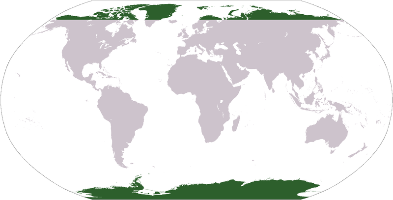
Map indicating the world's polar regions (i.e. Antarctica and area within Arctic Circle), based on Image:LocationAntarctica.png.

Perlesenan

Public domain
This image is in the public domain because it contains materials that originally came from the United States Central Intelligence Agency's World Factbook.

Bahasa Indonesia  čeština  Deutsch  eesti  English  español  Esperanto  français  galego  hrvatski  italiano  Nederlands  norsk nynorsk  polski  português  sicilianu  slovenščina  suomi  Türkçe  Zazaki  беларуская (тарашкевіца)  македонски  русский  српски / srpski  українська  ქართული  বাংলা  தமிழ்  മലയാളം  한국어  日本語  中文  中文(简体)  中文(繁體)  العربية  +/−

Captions

Add a one-line explanation of what this file represents

Items portrayed in this file

menggambarkan

Sejarah fail

Klik pada tarikh/waktu untuk melihat rupa fail tersebut pada waktu itu.

Tarikh/WaktuGambar kenitUkuranPenggunaKomen
semasa22:19, 28 Januari 2016Gambar kenit bagi versi pada 22:19, 28 Januari 20162,759 × 1,404 (92 KB)FogheIsle ? (green --> gray)
04:31, 31 Mac 2006Gambar kenit bagi versi pada 04:31, 31 Mac 20062,759 × 1,404 (51 KB)E Pluribus Anthony~commonswikiMap indicating the world's polar regions (i.e. Antarctica and area within Arctic Circle), derived on Image:LocationAntarctica.png
03:42, 31 Mac 2006Gambar kenit bagi versi pada 03:42, 31 Mac 20062,759 × 1,404 (55 KB)David Kernow~commonswikiMap indicating the world's polar regions (i.e. Antarctica and area within Arctic Circle), derived on Image:LocationAntarctica.png.

Penggunaan fail

Penggunaan fail sejagat

Metadata

{{bottomLinkPreText}} {{bottomLinkText}}
Fail:LocationPolarRegions.png
Listen to this article

This browser is not supported by Wikiwand :(
Wikiwand requires a browser with modern capabilities in order to provide you with the best reading experience.
Please download and use one of the following browsers:

This article was just edited, click to reload
This article has been deleted on Wikipedia (Why?)

Back to homepage

Please click Add in the dialog above
Please click Allow in the top-left corner,
then click Install Now in the dialog
Please click Open in the download dialog,
then click Install
Please click the "Downloads" icon in the Safari toolbar, open the first download in the list,
then click Install
{{::$root.activation.text}}

Install Wikiwand

Install on Chrome Install on Firefox
Don't forget to rate us

Tell your friends about Wikiwand!

Gmail Facebook Twitter Link

Enjoying Wikiwand?

Tell your friends and spread the love:
Share on Gmail Share on Facebook Share on Twitter Share on Buffer

Our magic isn't perfect

You can help our automatic cover photo selection by reporting an unsuitable photo.

This photo is visually disturbing This photo is not a good choice

Thank you for helping!


Your input will affect cover photo selection, along with input from other users.

X

Get ready for Wikiwand 2.0 🎉! the new version arrives on September 1st! Don't want to wait?