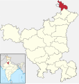
चित्र:India - Haryana - Panchkula.svg

मूळ संचिका (SVG संचिका, साधारणपणे ६७६ × ७१९ pixels, संचिकेचा आकार: १.६५ मे.बा.)
संचिकेचा इतिहास
संचिकेची त्यावेळची आवृत्ती बघण्यासाठी त्या दिनांक/वेळेवर टिचकी द्या.
| दिनांक/वेळ | छोटे चित्र | आकार | सदस्य | प्रतिक्रीया | |
|---|---|---|---|---|---|
| सद्य | १३:३५, ८ मार्च २०२२ |  | ६७६ × ७१९ (१.६५ मे.बा.) | Furfur | corrected district borders |
| १०:५३, १३ ऑगस्ट २०२१ |  | ८४५ × ८९९ (६०६ कि.बा.) | C1MM | c bounds | |
| १०:२५, २६ जुलै २०१८ |  | ६२६ × ७५० (४२३ कि.बा.) | Milenioscuro | corrected | |
| १८:४८, ५ जुलै २०१८ |  | ५७९ × ६११ (३६९ कि.बा.) | Ankit2 | Updated map with 22 districts. | |
| ०६:२७, ६ नोव्हेंबर २०१६ |  | ६२६ × ७५० (२९१ कि.बा.) | Milenioscuro | User created page with UploadWizard |
दुवे
खालील पाने या संचिकेला जोडली आहेत:
जागतिक संचिका उपयोग
संचिकाचे इतर विकिपीडियावरील वापरः
- arz.wikipedia.org वरील उपयोग
- awa.wikipedia.org वरील उपयोग
- bh.wikipedia.org वरील उपयोग
- bn.wikipedia.org वरील उपयोग
- de.wikipedia.org वरील उपयोग
- en.wikipedia.org वरील उपयोग
- es.wikipedia.org वरील उपयोग
- eu.wikipedia.org वरील उपयोग
- fa.wikipedia.org वरील उपयोग
- fi.wikipedia.org वरील उपयोग
- fr.wikipedia.org वरील उपयोग
- gu.wikipedia.org वरील उपयोग
- hi.wikipedia.org वरील उपयोग
- incubator.wikimedia.org वरील उपयोग
- ml.wikipedia.org वरील उपयोग
- nl.wikipedia.org वरील उपयोग
- no.wikipedia.org वरील उपयोग
- pa.wikipedia.org वरील उपयोग
- pnb.wikipedia.org वरील उपयोग
- ru.wikipedia.org वरील उपयोग
- sat.wikipedia.org वरील उपयोग
- sa.wikipedia.org वरील उपयोग
- simple.wikipedia.org वरील उपयोग
- ta.wikipedia.org वरील उपयोग
- te.wikipedia.org वरील उपयोग
- ur.wikipedia.org वरील उपयोग
- vi.wikipedia.org वरील उपयोग
- www.wikidata.org वरील उपयोग
- xmf.wikipedia.org वरील उपयोग
- zh-min-nan.wikipedia.org वरील उपयोग
मेटाडाटा
Text is available under the CC BY-SA 4.0 license; additional terms may apply.
Images, videos and audio are available under their respective licenses.
