चित्र:Europe subregion map UN geoscheme.svg

Size of this PNG preview of this SVG file: ६८० × ५२० पिक्सेल. इतर resolutions: ३१४ × २४० पिक्सेल | ६२८ × ४८० पिक्सेल | १,००४ × ७६८ पिक्सेल | १,२८० × ९७९ पिक्सेल | २,५६० × १,९५८ पिक्सेल.
मूळ संचिका (SVG संचिका, साधारणपणे ६८० × ५२० pixels, संचिकेचा आकार: ५७२ कि.बा.)
सारांश
| वर्णन |
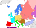
Deutsch: Subregionen Europas (nach UN Geoschema)
Nordeuropa
Westeuropa
Osteuropa
Südeuropa English: Subregions of Europe (UN geoscheme)
Northern Europe
Western Europe
Eastern Europe
Southern Europe
Countries of West Asia with partial territory in Southern Europe: Turkey
Countries of West Asia with partial territory in Eastern Europe: Georgia and Azerbaijan
Countries of Central Asia with partial territory in Eastern Europe: Kazakhstan
Русский: Макрорегионы Европы (классификация ООН)
Северная Европа
Западная Европа
Восточная Европа
Южная Европа
Страны макрорегиона Западная Азия с частичной территорией в Южной Европе: Турция
Страны макрорегиона Западная Азия с частичной территорией в Восточной Европе: Азербайджан и Грузия
Страны макрорегиона Центральная Азия с частичной территорией в Восточной Европе: Казахстан
Українська: Підрегіони Європи (класифікація Організації Об’єднаних Націй)
Північна Європа
Західна Європа
Східна Європа
Південна Європа Країни Західної Азії з частиною території в Південній Європі: Туреччина
Країни Західної Азії з частиною території в Східній Європі: Грузія та Азербайджан
Країни Центральної Азії з частиною території в Східній Європі: Казахстан
|
| दिनांक |
|
| स्रोत |
स्वतःचे काम |
| लेखक |
Kolja21 |
|Source=स्वतःचे काम |Author=Kolja21 |Date=2009-05-23 |Permission= |other_versions=Derivative works of this file:
-
 Subregions of Europe
(World Factbook) -
 Subregions of Europe
(UN geoschme) -
 Geografische und politische Grenzen Europas (2007) - DE
 -
 Political geography of Europe (2007) - EN
 -
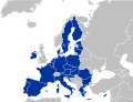 European Union
 -
 EU as a single entity
 -
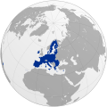 EU on a globe
 -
 EC-EU enlargement (animated)
 -
 Eastern Partnership
 -
 EU, EFTA and Eastern Partnership
 -
 EU membership possible


_de.png)
.png)


))
परवाना:
I, the copyright holder of this work, hereby publish it under the following license:
ही संचिका खालील परवान्याअंतर्गत आहे - क्रीएटिव्ह कॉमन्स Attribution 3.0 Unported.
- तुम्ही मुक्त आहात.
- सामायिक करा – नक्कल, वितरण आणि पारेषित करण्यास
- पुर्नमिश्रीत करण्यास – काम गरजेनुसार अनुकुलीत करण्यास
- खालील अटींच्या अधिन राहून:
- रोपण – आपण योग्य क्रेडिट देणे आवश्यक आहे, परवान्यास दुवा प्रदान करणे आवश्यक आहे, आणि बदल केले गेले आहेत हे दर्शविणे आवश्यक आहे. आपण हे कोणत्याही वाजवी मार्गाने करू शकता, परंतु परवानाधारक आपल्यास किंवा आपल्या वापरास मान्यता देतो अशा कोणत्याही मार्गाने नाही.
संचिकेचा इतिहास
संचिकेची त्यावेळची आवृत्ती बघण्यासाठी त्या दिनांक/वेळेवर टिचकी द्या.
| दिनांक/वेळ | छोटे चित्र | आकार | सदस्य | प्रतिक्रीया | |
|---|---|---|---|---|---|
| सद्य | २०:५७, १७ सप्टेंबर २०२४ | | ६८० × ५२० (५७२ कि.बा.) | Iktsokh | Clearing the map at the borders |
| १९:२०, ९ नोव्हेंबर २०२१ |  | ६८० × ५२० (२२८ कि.बा.) | TU-nor | Reverted to version as of 12:17, 22 February 2021 (UTC) No reason to color countries that are outside Europe in the Geosceme unless they are geographically transcontinental | |
| ०५:४२, ६ ऑगस्ट २०२१ |  | ६८० × ५२० (२६२ कि.बा.) | Vesperius | Cleanup at the edges. | |
| ०५:२३, ६ ऑगस्ट २०२१ |  | ६८० × ५२० (२३८ कि.बा.) | Vesperius | Cyprus and Armenia included. | |
| १७:४७, २२ फेब्रुवारी २०२१ |  | ६८० × ५२० (२२८ कि.बा.) | TU-nor | Andorra is Southern Europe in UN geoscheme | |
| १६:४७, २३ सप्टेंबर २०१५ |  | ६८० × ५२० (५७२ कि.बा.) | Alex Great | Reverted to version as of 09:22, 1 June 2014 | |
| १५:१८, १० जुलै २०१५ |  | ७४४ × १,०५२ (४३० कि.बा.) | Andrej500 | Crimea | |
| १४:५२, १ जून २०१४ |  | ६८० × ५२० (५७२ कि.बा.) | Insider | Russian Sochi Sector in Asia | |
| ००:२०, २८ मे २००९ |  | ६८० × ५२० (५७१ कि.बा.) | Kolja21 | ((Information |Description=((en|1=Subregions of Europe (UN geoschme))) ((de|1=Subregionen Europas (nach UN Geoschema))) |Source=Eigenes Werk (own work) |Author=Kolja21 |Date=2009-05-23 |Permission= |other_ |
दुवे
खालील पाने या संचिकेला जोडली आहेत:
जागतिक संचिका उपयोग
संचिकाचे इतर विकिपीडियावरील वापरः
- af.wikipedia.org वरील उपयोग
- am.wikipedia.org वरील उपयोग
- ar.wikipedia.org वरील उपयोग
- av.wikipedia.org वरील उपयोग
- awa.wikipedia.org वरील उपयोग
- azb.wikipedia.org वरील उपयोग
- ba.wikipedia.org वरील उपयोग
- be.wikipedia.org वरील उपयोग
- bn.wikipedia.org वरील उपयोग
- br.wikipedia.org वरील उपयोग
- ce.wikipedia.org वरील उपयोग
- cs.wikipedia.org वरील उपयोग
- cv.wikipedia.org वरील उपयोग
- cy.wikipedia.org वरील उपयोग
- de.wikipedia.org वरील उपयोग
- diq.wikipedia.org वरील उपयोग
- el.wikipedia.org वरील उपयोग
- en.wikipedia.org वरील उपयोग
या संचिकेचे अधिक वैश्विक उपयोग पहा
मेटाडाटा
Text is available under the CC BY-SA 4.0 license; additional terms may apply.
Images, videos and audio are available under their respective licenses.
Cover photo is available under {{::mainImage.info.license.name || 'Unknown'}} license.
Cover photo is available under {{::mainImage.info.license.name || 'Unknown'}} license.
Credit:
(see original file).
