For faster navigation, this Iframe is preloading the Wikiwand page for चित्र:India West Bengal location map.svg.

चित्र:India West Bengal location map.svg
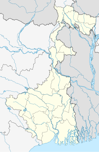
मूळ संचिका(SVG संचिका, साधारणपणे ९७४ × १,४८६ pixels, संचिकेचा आकार: ६३३ कि.बा.)

ही संचिका Wikimedia Commons येथील असून ती इतर प्रकल्पात वापरलेली असू शकते. तिचे तेथील संचिका वर्णन पान खाली दाखवले आहे.

सारांश

वर्णन
Deutsch: Positionskarte von Westbengalen, Indien

Quadratische Plattkarte, N-S-Streckung 110 %. Geographische Begrenzung der Karte:

  • N: 27.4° N
  • S: 21.3° N
  • W: 85.6° O
  • O: 90.0° O
English: Location map of West Bengal, India

Equirectangular projection, N/S stretching 110 %. Geographic limits of the map:

  • N: 27.4° N
  • S: 21.3° N
  • W: 85.6° E
  • E: 90.0° E
दिनांक
स्रोत

स्वतःचे काम, using

  • United States National Imagery and Mapping Agency data
  • World Data Base II data
लेखक NordNordWest
परवानगी
(या संचिकेचा पुनर्वापर करीत आहे)

I have published this file as author NordNordWest under the "CC-BY-SA-3.0-DE" in Wikipedia. This means that free, commercial usage outside of Wikipedia is permitted under the following licence terms:

Please send me a specimen copy or the URL of the website where the file is used.

Please write an email to nnwest[at]web.de if you

  • need my postal address for sending a specimen copy
  • have further questions about the terms of the licence

PS: In case of refusal of the above terms the author reserves the right to take legal action.

w:en:Creative Commons
रोपण जसेहोते-वाटातसेच (शेअर अलाईक)
ही संचिका खालील परवान्याअंतर्गत आहे - क्रीएटिव्ह कॉमन्स Attribution-Share Alike 3.0 जर्मनी.
तुम्ही मुक्त आहात.
  • सामायिक करा – नक्कल, वितरण आणि पारेषित करण्यास
  • पुर्नमिश्रीत करण्यास – काम गरजेनुसार अनुकुलीत करण्यास
खालील अटींच्या अधिन राहून:
  • रोपण – आपण योग्य क्रेडिट देणे आवश्यक आहे, परवान्यास दुवा प्रदान करणे आवश्यक आहे, आणि बदल केले गेले आहेत हे दर्शविणे आवश्यक आहे. आपण हे कोणत्याही वाजवी मार्गाने करू शकता, परंतु परवानाधारक आपल्यास किंवा आपल्या वापरास मान्यता देतो अशा कोणत्याही मार्गाने नाही.
  • जसेहोते-वाटातसेच (शेअर अलाईक) – जर तुम्ही या कामात काही बदल केलात, काटछाट केलीत, किंवा भर घातली, तर असे करून बनलेले नवीन काम तुम्ही केवळ या किंवा यासारख्याच परवान्याअंतर्गत प्रसारित करू शकतात.
Kartenwerkstatt
This map has been made or improved in the German Kartenwerkstatt (Map Lab). You can propose maps to improve as well.

Captions

Add a one-line explanation of what this file represents
West Bengal, a state of India

Items portrayed in this file

depicts इंग्रजी

copyright status इंग्रजी

copyrighted इंग्रजी

१ एप्रिल 2010

source of file इंग्रजी

original creation by uploader इंग्रजी

संचिकेचा इतिहास

संचिकेची त्यावेळची आवृत्ती बघण्यासाठी त्या दिनांक/वेळेवर टिचकी द्या.

दिनांक/वेळछोटे चित्रआकारसदस्यप्रतिक्रीया
सद्य०९:१७, १३ मे २०२२०९:१७, १३ मे २०२२ आवृत्तीसाठी छोटे चित्र९७४ × १,४८६ (६३३ कि.बा.)C1MMCorrected Bihar/Jharkhand border
१०:०२, ५ एप्रिल २०२११०:०२, ५ एप्रिल २०२१ आवृत्तीसाठी छोटे चित्र१,०३९ × १,५८५ (७२६ कि.बा.)C1MMCorrected rivers and coastline
१३:२१, ११ मार्च २०२११३:२१, ११ मार्च २०२१ आवृत्तीसाठी छोटे चित्र१,०३९ × १,५८५ (३६० कि.बा.)Sbb1413Updated to include newer districts.
०१:२२, २ एप्रिल २०१००१:२२, २ एप्रिल २०१० आवृत्तीसाठी छोटे चित्र१,०३९ × १,५८५ (३३२ कि.बा.)NordNordWest==((int:filedesc))== ((Information |Description= ((de|Positionskarte von Westbengalen, Indien)) Quadratische Plattkarte, N-S-Streckung 110 %. Geographische Begrenzung der Karte: * N: 27.4° N * S: 21.3° N * W: 85.6° O

दुवे

या चित्राशी जोडलेली पृष्ठे नाहीत.

जागतिक संचिका उपयोग

मेटाडाटा

{{bottomLinkPreText}} {{bottomLinkText}}
चित्र:India West Bengal location map.svg
Listen to this article

This browser is not supported by Wikiwand :(
Wikiwand requires a browser with modern capabilities in order to provide you with the best reading experience.
Please download and use one of the following browsers:

This article was just edited, click to reload
This article has been deleted on Wikipedia (Why?)

Back to homepage

Please click Add in the dialog above
Please click Allow in the top-left corner,
then click Install Now in the dialog
Please click Open in the download dialog,
then click Install
Please click the "Downloads" icon in the Safari toolbar, open the first download in the list,
then click Install
{{::$root.activation.text}}

Install Wikiwand

Install on Chrome Install on Firefox
Don't forget to rate us

Tell your friends about Wikiwand!

Gmail Facebook Twitter Link

Enjoying Wikiwand?

Tell your friends and spread the love:
Share on Gmail Share on Facebook Share on Twitter Share on Buffer

Our magic isn't perfect

You can help our automatic cover photo selection by reporting an unsuitable photo.

This photo is visually disturbing This photo is not a good choice

Thank you for helping!


Your input will affect cover photo selection, along with input from other users.

X

Get ready for Wikiwand 2.0 🎉! the new version arrives on September 1st! Don't want to wait?