മു കോ അങ് തൊങ് ദേശീയോദ്യാനം
| മു കോ അങ് തൊങ് ദേശീയോദ്യാനം | |
|---|---|
ഐ.യു.സി.എൻ. ഗണം II (ദേശീയോദ്യാനം) | |
 Ang Thong National Park from Ko Wua Talap | |
 Location in Thailand | |
| Location | Surat Thani Province, Thailand |
| Nearest city | Surat Thani |
| Coordinates | 9°37′22″N 99°40′30″E / 9.62278°N 99.67500°E |
| Area | 102 km2 (39 sq mi) |
| Established | 1980 |
| Governing body | National Park, Wildlife and Plant Conservation Department, Ministry of Natural Resources and Environment |
| Designated | 14 August 2002 |
| Reference no. | 1184[1] |
മു കോ അങ് തൊങ് ഗൾഫ് ഓഫ് തായ്ലാൻഡിലെ സൂററ്റ് തനി പ്രവിശ്യയിൽ കാണപ്പെടുന്ന ഒരു മറൈൻ ദേശീയോദ്യാനമാണ്. [2] മൊത്തം 102 കിലോമീറ്റർ പ്രദേശത്ത് 42 ദ്വീപുകളിലായി ഈ ദേശീയോദ്യാനം വ്യാപിച്ചുകിടക്കുന്നു, ഇതിൽ 50 km 2 കരയും ബാക്കി ജലവും ആണ്. 1980 നവംബർ 12 നാണ് ഈ ദേശീയോദ്യാനം സ്ഥാപിക്കപ്പെട്ടത്.[3] വടക്കൻ അറ്റം കോ ഫാലായ് മറൈൻ പാർക്കിന്റെ ഭാഗമാണ്. ഒരു റേഞ്ചർ സ്റ്റേഷൻ, ബംഗ്ലാവ്, ഒരു ഷോപ്പ്, കോ വുവ താലാപ്പിലെ അവോ ഫൈ ബീച്ചിൽ ഒരു റെസ്റ്റോറന്റ് എന്നിവയും കാണപ്പെടുന്നു.
"ആംഗ് താങ്" (തായ്: อ่างทอง) എന്ന പേര് "സ്വർണ്ണത്തിന്റെ പാത്രം"( 'bowl of gold').എന്നാണ്. "മു കോ" (หมู่ เกาะ) എന്നത് 'ദ്വീപുകളുടെ സമൂഹം' ('group of islands'.) എന്നാണ്.
2002 മുതൽ പാർക്ക് റാംസർ സൈറ്റ് നമ്പർ 1184 ആയി രജിസ്റ്റർ ചെയ്തിട്ടുണ്ട്. [3]
ദ്വീപുകൾ
[തിരുത്തുക]| Nr | Island | Capital | Other Cities | Area (km²) | Population |
|---|---|---|---|---|---|
| 1 | Ko Chueak | Ko Chueak | 1.62 | 0 | |
| 2 | Ko Nok Taphao | Ko Nok Taphao | Ao Kruat, Ao Pla, Ao Uttra, | 3.32 | 200 |
| 3 | Ko Phaluai | Ban Ao Sam | Ban Ao Song, Ban Ao Nueng, Ao nathap, Ao Luek | 19.1 | 500 |
| 4 | Ko Raet | Ko Raet | 0.07 | 50 | |
| 5 | Ko Samsao | Ko Samsao | 0.85 | 0 | |
| 6 | Ko Wua Chio | Ko Wua Chio | 0.26 | 2 | |
| 7 | Ko Wua Talap | Ang Thong Station | Ao Phi | 6.06 | 10 |
| 8 | More Islands | 10 | 0 | ||
| Total: | Mu Ko Ang Thong | Ban Ao Sam | Ko Nok Taphao | 40 | 692 |
ചിത്രശാല
[തിരുത്തുക]-
 Ang Thong National Park from Ko Wua Talab
 -
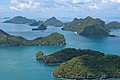 Ang Thong National Park from Ko Wua Talab
 -
 Beach, Ko Mae Ko
 -
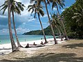
 Beach, Ko Wua Talab
 -
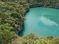 Laguna, Ko Mae Ko
 -


അവലംബം
[തിരുത്തുക]- ↑ "Mu Koh Ang Thong Marine National Park". Ramsar Sites Information Service. Retrieved 25 April 2018.
- ↑ "MU KO ANG THONG NATIONAL PARK". Tourism Authority of Thailand (TAT). Archived from the original on 2019-06-30. Retrieved 2 January 2018.
- ↑ 3.0 3.1 "Mu Ko Ang Thong National Park". Department of National Parks (DNP). Archived from the original on 11 November 2006. Retrieved 2 January 2018.
ബാഹ്യ ലിങ്കുകൾ
[തിരുത്തുക] Ang Thong National Park എന്ന വിഷയവുമായി ബന്ധമുള്ള കൂടുതൽ പ്രമാണങ്ങൾ (വിക്കിമീഡിയ കോമൺസിൽ)
Text is available under the CC BY-SA 4.0 license; additional terms may apply.
Images, videos and audio are available under their respective licenses.
Cover photo is available under {{::mainImage.info.license.name || 'Unknown'}} license.
Cover photo is available under {{::mainImage.info.license.name || 'Unknown'}} license.
Credit:
(see original file).
