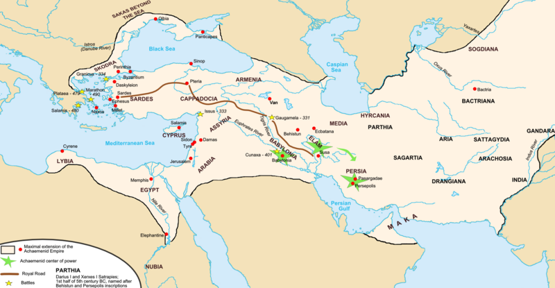
പ്രമാണം:Map achaemenid empire en.png

പൂർണ്ണ വലിപ്പം (1,676 × 869 പിക്സൽ, പ്രമാണത്തിന്റെ വലിപ്പം: 376 കെ.ബി., മൈം തരം: image/png)
പ്രമാണ നാൾവഴി
ഏതെങ്കിലും തീയതി/സമയ കണ്ണിയിൽ ഞെക്കിയാൽ പ്രസ്തുതസമയത്ത് ഈ പ്രമാണം എങ്ങനെയായിരുന്നു എന്നു കാണാം.
| തീയതി/സമയം | ലഘുചിത്രം | അളവുകൾ | ഉപയോക്താവ് | അഭിപ്രായം | |
|---|---|---|---|---|---|
| നിലവിലുള്ളത് | 04:35, 19 നവംബർ 2017 |  | 1,676 × 869 (376 കെ.ബി.) | R9tgokunks | Reverted to version as of 00:35, 14 October 2015 (UTC) |
| 08:36, 24 ഒക്ടോബർ 2017 |  | 1,676 × 869 (450 കെ.ബി.) | Mehrdad 12 | Reverted to version as of 21:38, 10 August 2015 (UTC) | |
| 00:35, 14 ഒക്ടോബർ 2015 |  | 1,676 × 869 (376 കെ.ബി.) | LouisAragon | For the last time; they did NOT conquer territoiry past the Indus River border as of on this map. | |
| 00:02, 12 ഒക്ടോബർ 2015 |  | 1,676 × 864 (484 കെ.ബി.) | History of Persia | Macedonia | |
| 23:58, 11 ഒക്ടോബർ 2015 |  | 1,676 × 869 (446 കെ.ബി.) | History of Persia | Yeah their included but the borders are innacurrate. Arabia extended deeper and the indus river itself was not the border itself. | |
| 02:33, 11 ഒക്ടോബർ 2015 |  | 1,676 × 869 (376 കെ.ബി.) | LouisAragon | The Indus and Northern Arabia are already included. Bring your concerns (with sources) to the Wikipedia talk page. | |
| 04:45, 14 ഓഗസ്റ്റ് 2015 |  | 1,676 × 869 (446 കെ.ബി.) | History of Persia | better | |
| 21:38, 10 ഓഗസ്റ്റ് 2015 |  | 1,676 × 869 (450 കെ.ബി.) | History of Persia | darius conquered the indus and arabia | |
| 21:38, 10 ഓഗസ്റ്റ് 2015 |  | 1,676 × 869 (450 കെ.ബി.) | History of Persia | darius conquered the indus and arabia | |
| 21:37, 10 ഓഗസ്റ്റ് 2015 |  | 1,676 × 869 (450 കെ.ബി.) | History of Persia | darius conquered the indus and arabia |
പ്രമാണത്തിന്റെ ഉപയോഗം
താഴെ കാണുന്ന 4 താളുകളിൽ ഈ ചിത്രം ഉപയോഗിക്കുന്നു:
പ്രമാണത്തിന്റെ ആഗോള ഉപയോഗം
താഴെ കൊടുത്തിരിക്കുന്ന മറ്റ് വിക്കികൾ ഈ പ്രമാണം ഉപയോഗിക്കുന്നു:
- als.wikipedia.org സംരംഭത്തിലെ ഉപയോഗം
- ar.wikipedia.org സംരംഭത്തിലെ ഉപയോഗം
- arz.wikipedia.org സംരംഭത്തിലെ ഉപയോഗം
- ast.wikipedia.org സംരംഭത്തിലെ ഉപയോഗം
- av.wikipedia.org സംരംഭത്തിലെ ഉപയോഗം
- azb.wikipedia.org സംരംഭത്തിലെ ഉപയോഗം
- az.wikipedia.org സംരംഭത്തിലെ ഉപയോഗം
- ba.wikipedia.org സംരംഭത്തിലെ ഉപയോഗം
- be.wikipedia.org സംരംഭത്തിലെ ഉപയോഗം
- bg.wikipedia.org സംരംഭത്തിലെ ഉപയോഗം
- bs.wikipedia.org സംരംഭത്തിലെ ഉപയോഗം
- bxr.wikipedia.org സംരംഭത്തിലെ ഉപയോഗം
- cs.wikipedia.org സംരംഭത്തിലെ ഉപയോഗം
- de.wikipedia.org സംരംഭത്തിലെ ഉപയോഗം
- diq.wikipedia.org സംരംഭത്തിലെ ഉപയോഗം
- el.wikipedia.org സംരംഭത്തിലെ ഉപയോഗം
- en.wikipedia.org സംരംഭത്തിലെ ഉപയോഗം
- Empire
- Talk:Iran/Archive 10
- Timeline of Jerusalem
- List of conflicts in Asia
- User talk:SG/Archive1
- Template talk:History of Afghanistan
- File talk:Map achaemenid empire en.png
- User:Ottava Rima/Persian Empire
- User:John K/Persian Empire
- Talk:Achaemenid Empire/Archive 1
- List of ancient great powers
- Wikipedia:Graphics Lab/Map workshop/Archive/Mar 2020
- User:Falcaorib/Ancient Empires (550-300 BC)
- en.wikibooks.org സംരംഭത്തിലെ ഉപയോഗം
- en.wiktionary.org സംരംഭത്തിലെ ഉപയോഗം
- eo.wikipedia.org സംരംഭത്തിലെ ഉപയോഗം
- es.wikipedia.org സംരംഭത്തിലെ ഉപയോഗം
- eu.wikipedia.org സംരംഭത്തിലെ ഉപയോഗം
ഈ പ്രമാണത്തിന്റെ കൂടുതൽ ആഗോള ഉപയോഗം കാണുക.
Text is available under the CC BY-SA 4.0 license; additional terms may apply.
Images, videos and audio are available under their respective licenses.


