ആൽബർട്ട് തടാകം
| ആൽബർട്ട് തടാകം | |
|---|---|
_(NASA).jpg) 2002 NASA MODIS satellite picture. The dotted grey line is the border between Congo (DRC) (left) and Uganda (right). | |
 ആൽബർട്ട് തടാകം  ആൽബർട്ട് തടാകം  ആൽബർട്ട് തടാകം | |
| നിർദ്ദേശാങ്കങ്ങൾ | 1°41′N 30°55′E / 1.683°N 30.917°E |
| പ്രാഥമിക അന്തർപ്രവാഹം | വിക്ടോറിയ നൈൽ സെംലിക്കി നദി |
| Primary outflows | ആൽബർട്ട് നൈൽ |
| Basin countries | DR കോംഗോ, ഉഗാണ്ട |
| പരമാവധി നീളം | 160 kilometres (99 mi) |
| പരമാവധി വീതി | 30 kilometres (19 mi) |
| ഉപരിതല വിസ്തീർണ്ണം | 5,300 square kilometres (2,000 sq mi) |
| ശരാശരി ആഴം | 25 metres (82 ft) |
| പരമാവധി ആഴം | 51 metres (167 ft) |
| Water volume | 132 cubic kilometres (32 cu mi)[1] |
| ഉപരിതല ഉയരം | 619 m (2,031 ft) |
| അധിവാസ സ്ഥലങ്ങൾ | Ntoroko, Kaiso, Butiaba, Wanseko, Panymur, Mahagi Port and Kasenyi Port |
| അവലംബം | [1] |
ആൽബർട്ട് തടാകം, ഉഗാണ്ടയിലും ഡെമോക്രാറ്റിക് റിപ്പബ്ലിക് ഓഫ് കോംഗോയിലും സ്ഥിതി ചെയ്യുന്ന ഒരു തടാകമാണ്. യഥാർത്ഥത്തിൽ എംവിറ്റാൻസിഗ് തടാകം എന്നും താൽക്കാലികമായി മൊബുട്ടു സെസെ സെക്കോ തടാകം എന്നും ഇത് അറിയപ്പെടുന്നു. ആഫ്രിക്കയിലെ ഏഴാമത്തെ വലിയ തടാകവും ഉഗാണ്ടയിലെ മഹാ തടാകങ്ങളിൽ രണ്ടാമത്തെ വലിയ തടാകവുമാണിത്.
ഭൂമിശാസ്ത്രം
[തിരുത്തുക]ആഫ്രിക്കൻ ഭൂഖണ്ഡത്തിന്റെ മധ്യഭാഗത്തായി ഉഗാണ്ടയുടെയും ഡെമോക്രാറ്റിക് റിപ്പബ്ലിക് ഓഫ് കോംഗോയുടെയും അതിർത്തിയിലാണ് ആൽബർട്ട് തടാകം സ്ഥിതി ചെയ്യുന്നത്. ഈസ്റ്റ് ആഫ്രിക്കൻ റിഫ്റ്റിൻറെ പടിഞ്ഞാറൻ ശാഖയായ ആൽബർട്ടൈൻ റിഫ്റ്റിലെ തടാകങ്ങളുടെ ശൃംഖലയുടെ വടക്കേയറ്റത്താണ് ഇതിൻറെ സ്ഥാനം. ഏകദേശം 160 കിലോമീറ്റർ (99 മൈൽ) നീളവും 30 കിലോമീറ്റർ (19 മൈൽ) വീതിയും 51 മീറ്റർ (167 അടി) പരമാവധി ആഴവുമുള്ള ഇതിന് സമുദ്രനിരപ്പിൽ നിന്ന് 619 മീറ്റർ (2,031 അടി) ഉയരമുണ്ട്.
ചിത്രശാല
[തിരുത്തുക]-
 സർ സാമുവൽ തടാകം പര്യവേക്ഷണം ചെയ്യുന്നു
 -
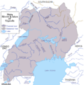 ഉഗാണ്ടയിലെ നദികളും തടാകങ്ങളും
 -
 ഫെറി
ഫെറി -
 ചാനൽ
ചാനൽ -
 തടാകക്കരയിലെ ജിറാഫ്


.jpg)
.jpg)
.jpg)
അവലംബം
[തിരുത്തുക]- ↑ 1.0 1.1 "The Nile". Archived from the original on October 6, 2007.
Text is available under the CC BY-SA 4.0 license; additional terms may apply.
Images, videos and audio are available under their respective licenses.
Cover photo is available under {{::mainImage.info.license.name || 'Unknown'}} license.
Cover photo is available under {{::mainImage.info.license.name || 'Unknown'}} license.
Credit:
(see original file).
