For faster navigation, this Iframe is preloading the Wikiwand page for Податотека:Map - NL - Municipality code 1783 (2009).svg.

Податотека:Map - NL - Municipality code 1783 (2009).svg
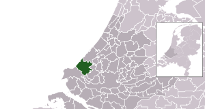
Изворна податотека(SVG податотека, номинално 300 × 160 пиксели, големина: 530 КБ)

Врска до Ризницата Ова е податотека од Ризницата на Викимедија и може да се користи на други проекти. Подолу е наведена содржината на нејзината описна страница.
Заедничката ризница е складиште на слободно-лиценцирани слики и снимки. И Вие можете да помогнете.
Опис
  • Location maps for the 441 municipalities in the Netherlands. Boundaries 1/1/2009
  • Automatically generated with script
  • File name contains "Municipality code" (CBS-code) as specified in: [1]
  • Created in svg using coordinate data derived from ESRI data published by Centraal Bureau voor de Statistiek, Voorburg/Heerlen. ([2])
  • Color coding and original design (slightly adpated by me) by user Mtcv (2006/2007) ([3])


© Праводржецот на оваа податотека, Centraal Bureau voor de Statistiek, дозволува секому да ја користи за било која цел, под услов да биде соодветно наведен. Дозволено е нејзино распространување, правење на изведени дела, комерцијална употреба и сите други цели.

VRT Wikimedia

Дозволата за користење на ова дело е потврдена и архивирана во Викимедииниот систем VRT.
Таа е достапна како билет #2007041210008226 за корисници со VRTS сметка. За да ја потврдите дозволата, контактирајте некој со сметка на VRTS или оставете порака на огласната табла на VRT.

Врска за потврдата: https://ticket.wikimedia.org/otrs/index.pl?Action=AgentTicketZoom&TicketNumber=2007041210008226
Find other files from the same ticket: SDC query (SPARQL)

This image is (in part or entirely) based on geographical data from Statistics Netherlands (Centraal Bureau voor de Statistiek). Digital geometry files in ESRI format can be downloaded from their website [4].

In particular, boundary data of statistical districts is based on either the Wijk- en buurtkaart 2005, or the Wijk- en buurtkaart 2003 ("CBS/TOPgrenzen"). Data on localities (bevolkingskernen) are from the publication Bevolkingskernen in Nederland 2001.

Conditions of use (in Dutch):

  • Bij visualisering van gegevens met behulp van het digitale bestand Wijk- en buurtkaart 2005 dient te worden vermeld:
Bron: © 2006, Centraal Bureau voor de Statistiek / Topografische Dienst Kadaster
  • Bij visualisering van gegevens met behulp van het digitale bestand CBS/TOPgrenzen dient te worden vermeld:
Grenzen ondergrond: © 2003, Centraal Bureau voor de Statistiek/Topografische Dienst Kadaster
  • Bij visualisering van gegevens met behulp van het digitale bestand "Bevolkingskernen 2001" dient te worden vermeld:
Bron: © 2005, Centraal Bureau voor de Statistiek

Unless otherwise specified, data on waterways and lakes are from the public domain Digital Chart of the World.

Датум
Извор own work , using CBS data
Автор Michiel1972 (talk) 00:18, 25 January 2009 (UTC)
Дозвола
(Повторно користење на податотекава)
Attribution ShareAlike 3.0
w:mk:Криејтив комонс
наведи извор сподели под исти услови
Можете:
  • да споделите – да го умножувате, распространувате и емитувате делото
  • да преработувате – да преработувате
Под следните услови:
  • наведи извор – Ќе мора да дадете прикладен припис, да ставите врска до лиценцата и да укажете дали има направено промени. Ова може да биде направено на било кој разумен начин, но без да оддава впечаток дека лиценцодавецот стои зад Вас и Вашата употреба.
  • сподели под исти услови – Ако го измените или преобразите делото, или пак ако основате друго дело на него, добиеното дело (придонесот) морате да го распространувате (објавувате) само под истата или складна лиценца на изворната.

Описи

Опишете во еден ред што претставува податотекава

Предмети прикажани на податотекава

прикажува

јануари 2009

Историја на податотеката

Стиснете на датум/време за да ја видите податотеката како изгледала тогаш.

Датум/времеМинијатураДимензииКорисникКоментар
тековна02:18, 25 јануари 2009Минијатура на верзијата од 02:18, 25 јануари 2009300 × 160 (530 КБ)Michiel1972((Information |Description=*Location maps for the 441 municipalities in the Netherlands. Boundaries 1/1/2009 *Automatically generated with script *File name contains "Municipality code" (CBS-code) as specified in: [http://www.cbs.nl/nl-NL/menu/methoden/c

Употреба на податотеката

Податотекава се користи во следнава страница:

Глобална употреба на податотеката

Оваа податотека ја користат и следниве викија:

Метаподатоци

{{bottomLinkPreText}} {{bottomLinkText}}
Податотека:Map - NL - Municipality code 1783 (2009).svg
Listen to this article

This browser is not supported by Wikiwand :(
Wikiwand requires a browser with modern capabilities in order to provide you with the best reading experience.
Please download and use one of the following browsers:

This article was just edited, click to reload
This article has been deleted on Wikipedia (Why?)

Back to homepage

Please click Add in the dialog above
Please click Allow in the top-left corner,
then click Install Now in the dialog
Please click Open in the download dialog,
then click Install
Please click the "Downloads" icon in the Safari toolbar, open the first download in the list,
then click Install
{{::$root.activation.text}}

Install Wikiwand

Install on Chrome Install on Firefox
Don't forget to rate us

Tell your friends about Wikiwand!

Gmail Facebook Twitter Link

Enjoying Wikiwand?

Tell your friends and spread the love:
Share on Gmail Share on Facebook Share on Twitter Share on Buffer

Our magic isn't perfect

You can help our automatic cover photo selection by reporting an unsuitable photo.

This photo is visually disturbing This photo is not a good choice

Thank you for helping!


Your input will affect cover photo selection, along with input from other users.

X

Get ready for Wikiwand 2.0 🎉! the new version arrives on September 1st! Don't want to wait?