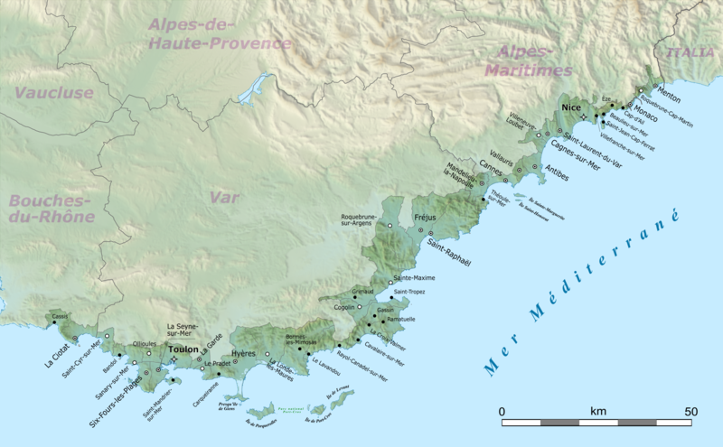
Attēls:Côte d’Azur map.png

Sākotnējais fails (6 148 × 3 801 pikseļi, faila izmērs: 11,09 MB, MIME tips: image/png)
Faila hronoloģija
Uzklikšķini uz datums/laiks kolonnā esošās saites, lai apskatītos, kā šis fails izskatījās tad.
| Datums/Laiks | Attēls | Izmēri | Dalībnieks | Komentārs | |
|---|---|---|---|---|---|
| tagadējais | 2022. gada 7. maijs, plkst. 12.42 |  | 6 148 × 3 801 (11,09 MB) | Pechristener | revised according to disc |
| 2021. gada 14. jūnijs, plkst. 01.41 |  | 6 148 × 3 801 (11,1 MB) | Pechristener | verbesserte Version | |
| 2021. gada 18. marts, plkst. 00.50 |  | 3 689 × 2 281 (5,08 MB) | Pechristener | ((Location|43.449856|6.5415625)) ((Information |Description=((en|Map of French Riviera, France.)) ((fr|Carte de la Côte d'Azur, France.))<br/> Geographic limits of the map:<br/> *Left: 5.359887<br/> *Right: 7.723238<br/> *Top: 43.979415<br/> *Bottom: 42.920297 |Source= * [http://www.openstreetmap.org Openstreetmap] data * relief: STRM data |Date=2021-03-10 |Author= * OpenStreetMap data: openStreetMap contributors * SRT... |
Faila lietojums
Šo failu izmanto šajā 1 lapā:
Globālais faila lietojums
Šīs Vikipēdijas izmanto šo failu:
- Izmantojums af.wikipedia.org
- Izmantojums ca.wikipedia.org
- Izmantojums ceb.wikipedia.org
- Izmantojums cs.wikipedia.org
- Izmantojums da.wikipedia.org
- Izmantojums de.wikipedia.org
- Monaco
- Nizza
- Cannes
- Hyères
- Toulon
- Côte d’Azur
- Bandol
- Sanary-sur-Mer
- Saint-Raphaël
- Saint-Tropez
- Menton
- Fréjus
- Antibes
- Saint-Jean-Cap-Ferrat
- La Croix-Valmer
- Èze
- Cassis
- Gassin
- La Ciotat
- Roquebrune-Cap-Martin
- Villeneuve-Loubet
- Grimaud
- Cagnes-sur-Mer
- Saint-Cyr-sur-Mer
- Le Lavandou
- Bormes-les-Mimosas
- Carqueiranne
- Ramatuelle
- Cogolin
- Villefranche-sur-Mer
- La Seyne-sur-Mer
- Six-Fours-les-Plages
- La Londe-les-Maures
- Sainte-Maxime
- Cavalaire-sur-Mer
- La Garde (Var)
- Le Pradet
- Ollioules
- Saint-Mandrier-sur-Mer
- Roquebrune-sur-Argens
- Saint-Laurent-du-Var
- Beaulieu-sur-Mer
- Cap-d’Ail
- Vallauris
- Mandelieu-la-Napoule
Skatīt šī faila pilno globālo izmantojumu.
Metadati
Text is available under the CC BY-SA 4.0 license; additional terms may apply.
Images, videos and audio are available under their respective licenses.


