Nicolas Sanson
| Nicolas Sanson | |
|---|---|

| |
| Gimė | 1600 m. gruodžio 20 d. Abvilis |
| Mirė | 1667 m. liepos 7 d. (66 metai) |
| Veikla | kartografas, geografas |
Nikola Sansonas (pranc. Nicolas Sanson; 1600 m. gruodžio 20 d. Abvilyje – 1667 m. liepos 7 d.) – Prancūzijos kartografas, dviejų karalių (Liudviko XIII ir Liudviko XIV) geografas, laikomas prancūzų kartografijos tėvu.[1]
Biografija
[redaguoti | redaguoti vikitekstą]Gimė 1600 m. Pikardijos mieste Abvilyje, turėjo škotiškų šaknų. Išsilavinimą įgijo Amjene pas jėzuitus. 1627 m. susilaukė kardinolo Rišeljė dėmesio, vėliau tapo karališkuoju geografu. Nors mirė 1667 m., tačiau N. Sansono vardu žemėlapiai leisti 1654–1676 m. Jo sūnus Guillaume Sanson taip pat leido žemėlapius, bendradarbiavo su Hubert Jaillot. 1692 m. N. Sansono žemėlapius išleido Hubert Jaillot savo rinkinyje „Atlas nouveau“.
Žemėlapiai
[redaguoti | redaguoti vikitekstą]N. Sansono žemėlapiai ne tik pasižymėjo tikslumu, bet juose atvaizduota LDK teritorija jau buvo suskirstyta į apskritis (pavietus). Be to, 1681 m. atlasas skirtas istoriniams žemėlapiams, siekiantiems senuosius amžius.
- XVII a. žemėlapiai
-

-
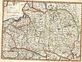
 Kuršas ir Žemaitija, 1659 m.
 -

-

-
-
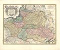
 Lenkijos žemėlapis, 1683 m.
 -

-
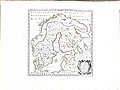
 Skandinavijos žemėlapis, ~1700 m. išleistas P. Schenko
 - Istoriniai žemėlapiai, išleisti 1681 m.
-

-

-
 Europa
 -
 Europa
 -
 Skandinavija
 -
 Skandinavija

.jpg)
.jpg)
.jpg)


.jpg)

.jpg)

.jpg)

Šaltiniai
[redaguoti | redaguoti vikitekstą]- ↑ Guiana and Caribana. Loc.gov (tikrinta 2021-12-26).
Text is available under the CC BY-SA 4.0 license; additional terms may apply.
Images, videos and audio are available under their respective licenses.
