Ferara
|
Chest artícol a l'è scricc in Lumbàrt, ortograféa orientàl unificàda. |
| Ferrara Comun | |||||
|---|---|---|---|---|---|
| |||||
 | |||||
| Dats aministrativ | |||||
| Nom ofiçal | Ferrara | ||||
| Stat | Itàlia | ||||
| Rejon | Emìlia-Romàgna | ||||
| Provinça | Provincia de Ferrara | ||||
| Lengue ofiçai | lèngua italiana | ||||
| Politega | |||||
| Sindeg | |||||
| Orgen lejislativ | Consili comunal | ||||
| Territore | |||||
| Coordinade | 44°50′07.07″N 11°37′11.51″E / 44.835297°N 11.619865°E | ||||
| OSM | 43512 | ||||
| Voltituden | 9 m s.l.m | ||||
| Superfix | 405,16 km² | ||||
| Abitants | 129 340 ab. (1º genar 2023) | ||||
| Densitaa | 319.23 ab./km² | ||||
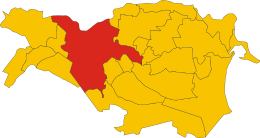
| Confin | Baricella, Bondeno, Copparo, Ficarolo, Masi Torello, Ostellato, Riva del Po, Tresignana, Voghiera, Argenta, Canaro, Occhiobello, Poggio Renatico, Vigarano Mainarda, Portomaggiore, Gaiba e Stienta | ||||
| Fus orari | UTC+01:00 e UTC+02:00 | ||||
| Varie | |||||
| Prefiss | 0532 | ||||
| Codex postal | 44121–44124 | ||||
| Sigla autom. | FE | ||||
| Codex ISTAT | 038008 | ||||
| Codex catastal | D548 | ||||
| Sant protetor | San Giorgg | ||||
| Cl. climatega | |||||
| Cl. sismega | |||||
| Localizazion | |||||
 | |||||
| Sit istituzional | |||||
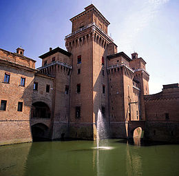
Ferara (endèla parlàda locàl: Frara; en fransés: Ferrare en italià Ferrara) l'è 'n cümü italià, de la regiù de l'Emìlia Romàgna, en Pruvìncia de Ferràra. El g'ha presapóch 130 461 abitàncc e 'l g'ha 'na superfìce de 404 km², per 'na densità de 323 ab./km². El cunfìna coi cümü de Argenta, Baricella (BO), Bondeno, Canaro (RO), Copparo, Ficarolo (RO), Formignana, Gaiba (RO), Masi Torello, Occhiobello (RO), Ostellato, Poggio Renatico, Ro, Stienta (RO), Tresigallo, Vigarano Mainarda, Voghiera.
Colocàda ai màrzegn del Po de Volano, en canàl che se destàca del córs principàl del Po, (che 'nvéce 'l pàsa 5 chilòmetri e mès piö a nòrt), la cità la rèsta apéna a 9 méter söl leèl del mar e la g'ha 'na strütüra urbanìstica che la risàl al sècol XIV, quan che l'ìa goernàda de la famìa dei Este.
Ferrara l'è giü dei quàter capoluòghi de pruvìncia italià (ensèma a Bèrghem, Lucca e Grosseto) che g'ha 'l cèntro stòrich completamènte cunturnàt de müre che i è restàde tàle e quàle 'ndèi sècoi. El piàno urbanìstich realizàt de Biagio Rossetti a pàrter del 1492 el l'ha trasfurmàda endèla prìma cità modèrna d'Europa, e de chèsto primàt derìa el sò recunusimènt endèl 1995 come Patremóne Mondiàl de l'Umanità del sò cèntro stòrich, istindìt endèl 1999 pò al Delta del Po.
Oter progecc
[Modifega | modifica 'l sorgent] Wikiquote el gh'ha dent citazzion de o su Ferara
 Wikinotizie el gh'ha dent notizzie in su Ferara
 Wikimedia Commons el gh'ha dent imagin o alter archivi su Ferara
 Wikivoyage el gh'ha dent Informazzion turisteghe su Ferara
Us curelade
[Modifega | modifica 'l sorgent]
Text is available under the CC BY-SA 4.0 license; additional terms may apply.
Images, videos and audio are available under their respective licenses.


