Ceba
Res apud Vicidata repertae:

Civitas: Italia
Locus: 44°23′0″N 8°2′0″E
Numerus incolarum: 5 695
Zona horaria: UTC+1, UTC+2
Situs interretialis
Nomen officiale: Ceva
Ceba: situs
Locus: 44°23′0″N 8°2′0″E
Numerus incolarum: 5 695
Zona horaria: UTC+1, UTC+2
Situs interretialis
Nomen officiale: Ceva
Gestio
Procuratio superior: Provincia Cuneensis
Geographia
Superficies: 42 chiliometrum quadratum, 43.17 chiliometrum quadratum
Territoria finitima: Battifolum, Castellinum ad Tanarum, Lesegnum, Mons Basilius, Nucetum, Palodium, Perlum, Ruasium Cebanorum, Salae Langarum, Salae Sancti Ioannis, Scagnellum, Petrarium
Territoria finitima: Battifolum, Castellinum ad Tanarum, Lesegnum, Mons Basilius, Nucetum, Palodium, Perlum, Ruasium Cebanorum, Salae Langarum, Salae Sancti Ioannis, Scagnellum, Petrarium
Coniunctiones urbium
Urbes gemellae: Le Val
Tabula aut despectus
.svg)

Ceba[1][2] (-ae, f.) (Italiane: Ceva) est Urbs Italiae et municipium, circiter 5 900 incolarum, in Regione Pedemontio et in Provincia Cuneensi sita. Urbani Cebates vel Cebani appellantur.

Insignia
[recensere | fontem recensere]-

-
 Urbs nomismate argenteo ob virtutem civilem decorata

Geographia
[recensere | fontem recensere]Fractiones, vici et loci in municipio
[recensere | fontem recensere]Fractiones
[recensere | fontem recensere]- Bertini,
- Infermiera,
- Mons Postremus, Malpotremo,
- Mollere,
- Poggi San Siro,
- Poggi Santo Spirito,
- Pratolungo.
Municipia
[recensere | fontem recensere]Battifollo, Castellino Tanaro, Lesegno, Mombasiglio, Nucetto, Paroldo, Perlo, Priero, Roascio, Sale delle Langhe, Sale San Giovanni, Scagnello.
Nexus interni
- Pedemontium (regio),
- Provincia Cuneensis,
- Langae (gen. Langarum),
- Cuneum (urbs),
- Urbes Italiae.
Nexus externi
[recensere | fontem recensere]| Vicimedia Communia plura habent quae ad Cebam spectant (Ceva, Ceva (Italy)). |
Pinacotheca
[recensere | fontem recensere]-
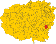
 Collocatio finium municipii in Provincia Cuneensi.

Notae
[recensere | fontem recensere]- ↑ G. Casalis, Dizionario geografico storico-statistico-commerciale degli stati di S. M. il Re di Sardegna (Taurinis: Maspero, 1833-1856)
- ↑ A. Chiusole, Il mondo antico, moderno, e novissimo, ovvero Breve trattato (Venetiarum: G. B. Recurti, 1749)
 |
Text is available under the CC BY-SA 4.0 license; additional terms may apply.
Images, videos and audio are available under their respective licenses.
Cover photo is available under {{::mainImage.info.license.name || 'Unknown'}} license.
Cover photo is available under {{::mainImage.info.license.name || 'Unknown'}} license.
Credit:
(see original file).
