Campaniaticum
Locus: 42°53′4″N 11°16′17″E
Numerus incolarum: 2 345
Zona horaria: UTC+1, UTC+2
Situs interretialis
Nomen officiale: Campagnatico
Gestio
Geographia
Regiones urbanae: Arcille, Marrucheti, Montorsaio
Territoria finitima: Arcidossum, Cinisianum, Civitella - Paganicum, Grossetum, Rocca Albinia, Rocha ad Stratam, Scansanum
Coniunctiones urbium
Tabula aut despectus
Campaniaticum[1][2] (-i, n.) (alia nomina: Campagnaticum[3][4]) (Italiane: Campagnatico) est oppidum Italiae et municipium, circiter 2 420 incolarum, in Regione Tuscia et in Provincia Grossetana situm. Incolae Campaniaticenses appellantur.
Insigne
[recensere | fontem recensere]Clari cives
[recensere | fontem recensere]Hic vixerunt
[recensere | fontem recensere]Ecclesia Catholica Romana
[recensere | fontem recensere]Fractiones, vici et loci in municipio
[recensere | fontem recensere]Fractiones
[recensere | fontem recensere]Arcille, Marrucheti, Montorsaio, Sant'Antonio
Municipia finitima
[recensere | fontem recensere]Nexus interni
- Tuscia (regio),
- Provincia Grossetana,
- Grossetum (urbs),
- Municipium Italiae.
Nexus externi
[recensere | fontem recensere]Vicimedia Communia plura habent quae ad Campaniaticum spectant. |
Pinacotheca
[recensere | fontem recensere]-
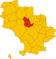
Collocatio finium municipii in Provincia Grossetana.
-
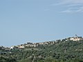
Despectus in Campaniaticum.
Notae
[recensere | fontem recensere]- ↑ E. Repetti, Dizionario geografico, fisico e storico della Toscana (Florentiae, 1830)
- ↑ Breve istoria del Dominio temporale Della sede Apostolicai nelle Siciliae... 1788
- ↑ Italia Illustrata - Di Biondo Flavio
- ↑ Nomi d'Italia - AAVV, De Agostini
Text is available under the CC BY-SA 4.0 license; additional terms may apply.
Images, videos and audio are available under their respective licenses.