For faster navigation, this Iframe is preloading the Wikiwand page for 야소톤주.

야소톤주

야소톤주
ยโสธร
깃발 문장
국가 태국 태국
면적 4,161.7 km2
인구 561,430명
(2000년 기준)
주도 야소톤
시간대 UTC+7
ISO 3166-2 TH-35
홈페이지 http://www.yasothon.go.th/

야소톤주(태국어: ยโสธร)는 태국 북동부의 주(창왓)의 하나이다. 이웃한 주는 북쪽부터 시계 방향으로 묵다한 주, 암낫차른 주, 우본랏차타니 주, 시사껫 주, 로이엣 주이다.

지리

[편집]

주의 북부는 평야와 낮은 언덕인 반면에 남부는 치 강의 저지로 몇 개의 연못과 늪이 있다.

역사

[편집]

주는 1972년 3월 1일에 우본랏차타니 주로부터 분리되어 설치되었다.

행정 구역

[편집]

주에는 9개의 암프(군)와 더 세부 행정구역인 78개의 땀본 그리고 835개의 무반 (행정 구역)이 있다.
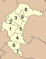
  1. 므앙야소톤군
  2. 사이문군
  3. 꿋춤군
  4. 캄크안깨오군
  5. 빠띠오군
  6. 마하차나차이군
  7. 코왕군
  8. 릉녹타군
  9. 타이차른군

외부 링크

[편집]
{{bottomLinkPreText}} {{bottomLinkText}}
야소톤주
Listen to this article

This browser is not supported by Wikiwand :(
Wikiwand requires a browser with modern capabilities in order to provide you with the best reading experience.
Please download and use one of the following browsers:

This article was just edited, click to reload
This article has been deleted on Wikipedia (Why?)

Back to homepage

Please click Add in the dialog above
Please click Allow in the top-left corner,
then click Install Now in the dialog
Please click Open in the download dialog,
then click Install
Please click the "Downloads" icon in the Safari toolbar, open the first download in the list,
then click Install
{{::$root.activation.text}}

Install Wikiwand

Install on Chrome Install on Firefox
Don't forget to rate us

Tell your friends about Wikiwand!

Gmail Facebook Twitter Link

Enjoying Wikiwand?

Tell your friends and spread the love:
Share on Gmail Share on Facebook Share on Twitter Share on Buffer

Our magic isn't perfect

You can help our automatic cover photo selection by reporting an unsuitable photo.

This photo is visually disturbing This photo is not a good choice

Thank you for helping!


Your input will affect cover photo selection, along with input from other users.

X

Get ready for Wikiwand 2.0 🎉! the new version arrives on September 1st! Don't want to wait?