For faster navigation, this Iframe is preloading the Wikiwand page for 사용자:배우는사람/문서:인도의 지형.

사용자:배우는사람/문서:인도의 지형

지형도

[편집]
인도의 지형

산맥

[편집]
인도의 산맥

[편집]
인도의 강
Map of the Ganges (orange), Brahmaputra (violet), and Meghna (green) drainage basins.
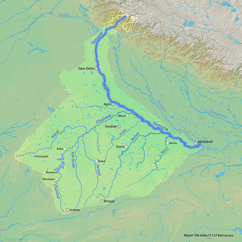
Yamuna River drainage basin map.
Map of the main rivers of the Indus Basin.

강과 호수

[편집]
인도의 강과 호수
인도의 강과 호수

행정 구역

[편집]
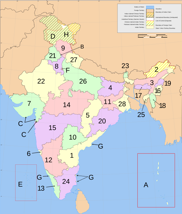
Map of India showing its subdivision into states and territories
The 28 states and 7 union territories of India

Administrative divisions India consists of 28 states and seven Union Territories. All states, and the two union territories of Puducherry and the National Capital Territory of Delhi, have elected legislatures and governments patterned on the Westminster model. The other five union territories are directly ruled by the Centre through appointed administrators. In 1956, under the States Reorganisation Act, states were formed on a linguistic basis.[1] Since then, this structure has remained largely unchanged. Each state or union territory is further divided into administrative districts.[2] The districts in turn are further divided into tehsils and eventually into villages.
States:
  1. Andhra Pradesh
  2. Arunachal Pradesh
  3. Assam
  4. Bihar
  5. Chhattisgarh
  6. Goa
  7. Gujarat
  1. Haryana
  2. Himachal Pradesh
  3. Jammu and Kashmir
  4. Jharkhand
  5. Karnataka
  6. Kerala
  7. Madhya Pradesh
  1. Maharashtra
  2. Manipur
  3. Meghalaya
  4. Mizoram
  5. Nagaland
  6. Orissa
  7. Punjab
  1. Rajasthan
  2. Sikkim
  3. Tamil Nadu
  4. Tripura
  5. Uttar Pradesh
  6. Uttarakhand
  7. West Bengal
Union Territories:
  1. Andaman and Nicobar Islands
  2. Chandigarh
  3. Dadra and Nagar Haveli
  4. Daman and Diu
  5. Lakshadweep
  6. National Capital Territory of Delhi
  7. Puducherry

주석

[편집]
  1. “States Reorganisation Act, 1956”. 《Constitution of India》. Commonwealth Legal Information Institute. 2007년 10월 31일에 확인함. ; See also: Political integration of India.
  2. “Districts of India”. 《Government of India》. National Informatics Centre (NIC). 2007년 11월 25일에 확인함. 
{{bottomLinkPreText}} {{bottomLinkText}}
사용자:배우는사람/문서:인도의 지형
Listen to this article

This browser is not supported by Wikiwand :(
Wikiwand requires a browser with modern capabilities in order to provide you with the best reading experience.
Please download and use one of the following browsers:

This article was just edited, click to reload
This article has been deleted on Wikipedia (Why?)

Back to homepage

Please click Add in the dialog above
Please click Allow in the top-left corner,
then click Install Now in the dialog
Please click Open in the download dialog,
then click Install
Please click the "Downloads" icon in the Safari toolbar, open the first download in the list,
then click Install
{{::$root.activation.text}}

Install Wikiwand

Install on Chrome Install on Firefox
Don't forget to rate us

Tell your friends about Wikiwand!

Gmail Facebook Twitter Link

Enjoying Wikiwand?

Tell your friends and spread the love:
Share on Gmail Share on Facebook Share on Twitter Share on Buffer

Our magic isn't perfect

You can help our automatic cover photo selection by reporting an unsuitable photo.

This photo is visually disturbing This photo is not a good choice

Thank you for helping!


Your input will affect cover photo selection, along with input from other users.

X

Get ready for Wikiwand 2.0 🎉! the new version arrives on September 1st! Don't want to wait?