For faster navigation, this Iframe is preloading the Wikiwand page for ಚಿತ್ರ:Relief map of Guatemala.jpg.

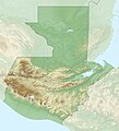
ಚಿತ್ರ:Relief map of Guatemala.jpg

ಮೂಲ ಕಡತ(೧,೧೬೦ × ೧,೨೭೬ ಚಿತ್ರಬಿಂದು, ಫೈಲಿನ ಗಾತ್ರ: ೪೯೭ KB, MIME ಪ್ರಕಾರ: image/jpeg)

ಈ ಫೈಲು ವಿಕಿಮೀಡಿಯ ಕಾಮನ್ಸ್ನಲ್ಲಿ ಇರುವುದು. ಅಲ್ಲಿನ ವಿವರಣೆ ಪುಟವನ್ನೇ ಕೆಳಗೆ ತೋರಿಸಲಾಗಿದೆ. ಕಾಮನ್ಸ್ ಕೃತಿಸ್ವಾಮ್ಯತೆಯಿಂದ ಮುಕ್ತ ಫೈಲುಗಳ ಒಂದು ಆಗರ. ಅಲ್ಲಿ ನೀವೂ ಸಹಕರಿಸಬಹುದು.

ಸಾರಾಂಶ

ವಿವರ
Русский: Физическая карта Гватемалы
  • Проекция — равноугольная цилиндрическая
  • Координаты краёв карты:
| top    = 18.0436
| bottom = 13.5235
| left   = -92.3592
| right  = -88.0458
Español: Mapa físico de Guatemala
ದಿನಾಂಕ
ಆಕರ
ಕರ್ತೃ
ಇತರೆ ಆವೃತ್ತಿಗಳು Derivative works of this file:  Franja transversal guate relief.jpg

ಪರವಾನಗಿ

w:en:Creative Commons
ವೈಶಿಷ್ಟ್ಯ ಇರುವುದರಂತೆಯೇ ಹಂಚು
This file is licensed under the Creative Commons Attribution-Share Alike 2.0 Generic license.
ನೀವು ಮುಕ್ತ:
  • ಹಂಚಿಕೆಗೆ – ಕೆಲಸವನ್ನು ನಕಲು ಮಾಡಲು, ವಿತರಣೆ ಮತ್ತು ಸಾಗಿಸಲು
  • ರೀಮಿಕ್ಸ್ ಮಾಡಲು – ಕೆಲಸವನ್ನು ಬಳಸಿಕೊಳ್ಳಲು
ಈ ಕೆಳಗಿನ ಷರತ್ತುಗಳಲ್ಲಿ:
  • ವೈಶಿಷ್ಟ್ಯ – ನೀವು ಸೂಕ್ತವಾದ ಕ್ರೆಡಿಟ್ ನೀಡಬೇಕು, ಪರವಾನಗಿಗೆ ಲಿಂಕ್ ಅನ್ನು ಒದಗಿಸಬೇಕು ಮತ್ತು ಯಾವುದೇ ಬದಲಾವಣೆಗಳನ್ನು ಮಾಡಿದ್ದರೆ ಸೂಚಿಸಬೇಕು. ನೀವು ಯಾವುದೇ ಸಮಂಜಸವಾದ ರೀತಿಯಲ್ಲಿ ಮಾಡಬಹುದು, ಆದರೆ ಪರವಾನಗಿದಾರರು ನಿಮ್ಮನ್ನು ಅಥವಾ ನಿಮ್ಮ ಯಾವುದೇ ಬಳಕೆಯನ್ನು ಅನುಮೋದಿಸಿದಂತೆ ರೀತಿಯಲ್ಲಿ ಉಪಯೋಗಿಸಬಾರದು.
  • ಇರುವುದರಂತೆಯೇ ಹಂಚು – ನೀವು ರೀಮಿಕ್ಸ್ ಮಾಡಿದರೆ, ರೂಪಾಂತರಗೊಳಿಸಿದರೆ ಅಥವಾ ವಸ್ತುವಿನ ಮೇಲೆ ನಿರ್ಮಿಸಿದರೆ, ನಿಮ್ಮ ಕೊಡುಗೆಗಳನ್ನು ನೀವು ಮೂಲದಂತೆ ಅದೇ ಅಥವಾ ಹೊಂದಾಣಿಕೆಯ ಪರವಾನಗಿ ಅಡಿಯಲ್ಲಿ ವಿತರಿಸಬೇಕು.

Captions

Add a one-line explanation of what this file represents

Items portrayed in this file

depicts ಇಂಗ್ಲಿಷ್

Santa Ana Mixtán ಇಂಗ್ಲಿಷ್

copyright status ಇಂಗ್ಲಿಷ್

copyrighted ಇಂಗ್ಲಿಷ್

೧೮ ನವೆಂಬರ್ 2010

media type ಇಂಗ್ಲಿಷ್

image/jpeg

ಕಡತದ ಇತಿಹಾಸ

ದಿನ/ಕಾಲ ಒತ್ತಿದರೆ ಆ ಸಮಯದಲ್ಲಿ ಈ ಕಡತದ ವಸ್ತುಸ್ಥಿತಿ ತೋರುತ್ತದೆ.

ದಿನ/ಕಾಲಕಿರುನೋಟಆಯಾಮಗಳುಬಳಕೆದಾರಟಿಪ್ಪಣಿ
ಪ್ರಸಕ್ತ೦೪:೧೫, ೨೯ ಮೇ ೨೦೧೫೦೪:೧೫, ೨೯ ಮೇ ೨೦೧೫ ವರೆಗಿನ ಆವೃತ್ತಿಯ ಕಿರುನೋಟ೧,೧೬೦ × ೧,೨೭೬ (೪೯೭ KB)Ikonacta new try with correct relief
೧೨:೩೯, ೨೧ ಮೇ ೨೦೧೫೧೨:೩೯, ೨೧ ಮೇ ೨೦೧೫ ವರೆಗಿನ ಆವೃತ್ತಿಯ ಕಿರುನೋಟ೧,೧೬೦ × ೧,೨೭೬ (೪೪೫ KB)IkonactThe version from 21 November 2010 is with wrong relief
೦೦:೩೫, ೨೨ ನವೆಂಬರ್ ೨೦೧೦೦೦:೩೫, ೨೨ ನವೆಂಬರ್ ೨೦೧೦ ವರೆಗಿನ ಆವೃತ್ತಿಯ ಕಿರುನೋಟ೧,೧೬೦ × ೧,೨೭೫ (೪೫೪ KB)Виктор Вм
೦೦:೪೩, ೧೯ ನವೆಂಬರ್ ೨೦೧೦೦೦:೪೩, ೧೯ ನವೆಂಬರ್ ೨೦೧೦ ವರೆಗಿನ ಆವೃತ್ತಿಯ ಕಿರುನೋಟ೧,೧೬೦ × ೧,೨೭೬ (೪೪೫ KB)Виктор В== ((int:filedesc)) == ((Information |Description=((ru|1=Физическая карта Гватемалы * Проекция — равноугольная цилиндрическая * Координаты краёв карты: <pre> | top = 18.04

ಕಡತ ಬಳಕೆ

ಈ ಕೆಳಗಿನ ಪುಟವು ಈ ಚಿತ್ರಕ್ಕೆ ಸಂಪರ್ಕ ಹೊಂದಿದೆ:

ಜಾಗತಿಕ ಕಡತ ಉಪಯೋಗ

ಈ ಕಡತವನ್ನು ಕೆಳಗಿನ ಬೇರೆ ವಿಕಿಗಳೂ ಉಪಯೋಗಿಸುತ್ತಿವೆ:

ಈ ಫೈಲ್‌ನ ಹೆಚ್ಚು ಜಾಗತಿಕ ಬಳಕೆಯನ್ನು ವೀಕ್ಷಿಸಿ.

"https://kn.wikipedia.org/wiki/ಚಿತ್ರ:Relief_map_of_Guatemala.jpg" ಇಂದ ಪಡೆಯಲ್ಪಟ್ಟಿದೆ
{{bottomLinkPreText}} {{bottomLinkText}}
ಚಿತ್ರ:Relief map of Guatemala.jpg
Listen to this article

This browser is not supported by Wikiwand :(
Wikiwand requires a browser with modern capabilities in order to provide you with the best reading experience.
Please download and use one of the following browsers:

This article was just edited, click to reload
This article has been deleted on Wikipedia (Why?)

Back to homepage

Please click Add in the dialog above
Please click Allow in the top-left corner,
then click Install Now in the dialog
Please click Open in the download dialog,
then click Install
Please click the "Downloads" icon in the Safari toolbar, open the first download in the list,
then click Install
{{::$root.activation.text}}

Install Wikiwand

Install on Chrome Install on Firefox
Don't forget to rate us

Tell your friends about Wikiwand!

Gmail Facebook Twitter Link

Enjoying Wikiwand?

Tell your friends and spread the love:
Share on Gmail Share on Facebook Share on Twitter Share on Buffer

Our magic isn't perfect

You can help our automatic cover photo selection by reporting an unsuitable photo.

This photo is visually disturbing This photo is not a good choice

Thank you for helping!


Your input will affect cover photo selection, along with input from other users.

X

Get ready for Wikiwand 2.0 🎉! the new version arrives on September 1st! Don't want to wait?