For faster navigation, this Iframe is preloading the Wikiwand page for ფაილი:Mexico map, MX-MIC.svg.

ფაილი:Mexico map, MX-MIC.svg
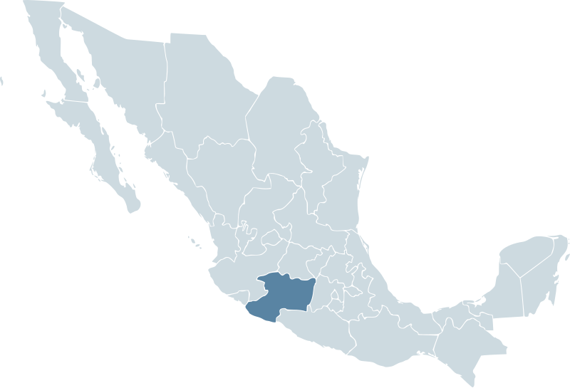
თავდაპირველი ფაილი(ფაილი SVG, ნომინალურად 1 000 × 680 პიქსელი, ფაილის ზომა: 123 კბ)

ეს ფაილი მდებარეობს Wikimedia Commons სერვერზე.
იხილეთ მისი აღწერის გვერდი სრული ინფორმაციისთვის.
გადასვლა ფაილის გვერდზე
აღწერა Locator map for the state of Michoacán within Mexico.
თარიღი 04-07-2007
წყარო Mexico template.svg by Mario Fuente Cid and Lokal_Profil
ავტორი Lokal_Profil
უფლება
(ფაილის მეორეული გამოყენება)

Original image licensed under

Public domain ეს ნამუშევარი მისი ავტორის Ek Balam მიერ გადაცემულია საზოგადოებრივ დომენში. ეს მოქმედებს მთელი მსოფლიოს მასშტაბით.

ზოგიერთ ქვეყანაში ეს შეიძლება იურიდიულად შეუძლებელი იყოს, ასეთ შემთხვევაში:
Ek Balam უფლება მისცა ნებისმიერს, რათა გამოიყენონ ეს ნამუშევარი ნებისმიერი მიზნით, ყოველგვარი წინაპირობის გარეშე, თუ რაიმე პირობა კანონის მიერ არ არის მოთხოვნილი.

my edits licensed under
Public domain
This work is based on a work in the public domain. It has been digitally enhanced and/or modified. This derivative work has been (or is hereby) released into the public domain by its author, Lokal_Profil. This applies worldwide.

In some countries this may not be legally possible; if so:

Lokal_Profil grants anyone the right to use this work for any purpose, without any conditions, unless such conditions are required by law.

Captions

Add a one-line explanation of what this file represents

ფაილის ისტორია

დააწკაპუნეთ თარიღზე/დროზე ფაილის დასათვალიერებლად, როგორც ის მაშინ გამოიყურებოდა.

თარიღი/დრომინიატიურაზომებიმომხმარებელიშენიშვნა
მიმდინარე00:05, 18 ნოემბერი 2009მინიატურა 00:05, 18 ნოემბერი 2009 ვერსიისთვის1 000×680 (123 კბ)Addicted04Reverted to version as of 01:42, 19 November 2007
01:34, 1 ოქტომბერი 2009მინიატურა 01:34, 1 ოქტომბერი 2009 ვერსიისთვის1 000×680 (267 კბ)Addicted04States borders
01:42, 19 ნოემბერი 2007მინიატურა 01:42, 19 ნოემბერი 2007 ვერსიისთვის1 000×680 (123 კბ)El bart089Based on the image made by Lokal Profil
17:27, 4 ივლისი 2007მინიატურა 17:27, 4 ივლისი 2007 ვერსიისთვის1 000×680 (117 კბ)Lokal Profil((Information |Description=Locator map for the state of Category:Michoacán within Mexico. |Source=Image:Mexico template.svg by Mario Fuente Cid <small>and Lokal_Profil</small> |Date=04-07-2007 |Author=

ბმულები

ამ ფაილზე ბმული მოცემულია შემდეგ გვერდებზე:

ფაილის გლობალური გამოყენება

ეს ფაილი გამოიყენება შემდეგ ვიკებში:

მოძიებულია „https://ka.wikipedia.org/wiki/ფაილი:Mexico_map,_MX-MIC.svg“-დან
{{bottomLinkPreText}} {{bottomLinkText}}
ფაილი:Mexico map, MX-MIC.svg
Listen to this article

This browser is not supported by Wikiwand :(
Wikiwand requires a browser with modern capabilities in order to provide you with the best reading experience.
Please download and use one of the following browsers:

This article was just edited, click to reload
This article has been deleted on Wikipedia (Why?)

Back to homepage

Please click Add in the dialog above
Please click Allow in the top-left corner,
then click Install Now in the dialog
Please click Open in the download dialog,
then click Install
Please click the "Downloads" icon in the Safari toolbar, open the first download in the list,
then click Install
{{::$root.activation.text}}

Install Wikiwand

Install on Chrome Install on Firefox
Don't forget to rate us

Tell your friends about Wikiwand!

Gmail Facebook Twitter Link

Enjoying Wikiwand?

Tell your friends and spread the love:
Share on Gmail Share on Facebook Share on Twitter Share on Buffer

Our magic isn't perfect

You can help our automatic cover photo selection by reporting an unsuitable photo.

This photo is visually disturbing This photo is not a good choice

Thank you for helping!


Your input will affect cover photo selection, along with input from other users.

X

Get ready for Wikiwand 2.0 🎉! the new version arrives on September 1st! Don't want to wait?