ფაილი:Karta PG Trobriand isl.PNG
უფრო მაღალი გარჩევადობა არ არის შესაძლებელი.
Karta_PG_Trobriand_isl.PNG ((300 × 200 პიქსელი, ფაილის ზომა: 4 კბ, MIME ტიპი: image/png))
| ეს ფაილი მდებარეობს Wikimedia Commons სერვერზე. იხილეთ მისი აღწერის გვერდი სრული ინფორმაციისთვის. |
 |
გადასვლა ფაილის გვერდზე |
რეზიუმე
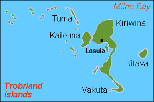
| აღწერა |
English: Map (rough) of Trobriand islands, Papua New Guinea, own work composed from various mapreferences |
| თარიღი | |
| წყარო | პირადი ნამუშევარი |
| ავტორი | Hobe / Holger Behr |
ლიცენზია
| მე, ამ ნამუშევრის საავტორო უფლების მფლობელი, გადავცემ მას საზოგადოებრივ დომენში. ეს უფლება ვრცელდება მთელი მსოფლიოს მასშტაბით. ზოგიერთ ქვეყანაში ეს შეიძლება იურიდიულად შეუძლებელი იყოს, ასეთ შემთხვევაში: მე ვაძლევ უფლებას ნებისმიერს, რათა გამოიყენონ ეს ნამუშევარი ნებისმიერი მიზნით, ყოველგვარი წინაპირობის გარეშე, გარდა კანონით გათვალისწინებული შემთხვევებისა. |
ფაილის ისტორია
დააწკაპუნეთ თარიღზე/დროზე ფაილის დასათვალიერებლად, როგორც ის მაშინ გამოიყურებოდა.
| თარიღი/დრო | მინიატიურა | ზომები | მომხმარებელი | შენიშვნა | |
|---|---|---|---|---|---|
| მიმდინარე | 15:52, 12 მაისი 2007 | | 300×200 (4 კბ) | Hobe | ((Information |Description=map Trobriand islands, Papua New Guinea |Source=own work, composed from various mapreferences |Date=2007-04-25 |Author=Holger Behr |Permission= |other_versions= )) |
ბმულები
ამ ფაილზე ბმული მოცემულია შემდეგ გვერდებზე:
ფაილის გლობალური გამოყენება
ეს ფაილი გამოიყენება შემდეგ ვიკებში:
- გამოყენება als.wikipedia.org-ში
- გამოყენება de.wikipedia.org-ში
- გამოყენება en.wikipedia.org-ში
- გამოყენება eo.wikipedia.org-ში
- გამოყენება es.wikipedia.org-ში
- გამოყენება fa.wikipedia.org-ში
- გამოყენება frr.wikipedia.org-ში
- გამოყენება gl.wikipedia.org-ში
- გამოყენება it.wikipedia.org-ში
- გამოყენება ja.wikipedia.org-ში
- გამოყენება nl.wikipedia.org-ში
- გამოყენება pnb.wikipedia.org-ში
- გამოყენება sv.wikipedia.org-ში
- გამოყენება zh.wikipedia.org-ში
Text is available under the CC BY-SA 4.0 license; additional terms may apply.
Images, videos and audio are available under their respective licenses.
Cover photo is available under {{::mainImage.info.license.name || 'Unknown'}} license.
Cover photo is available under {{::mainImage.info.license.name || 'Unknown'}} license.
Credit:
(see original file).
