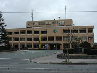
ოირასე
| დასახლება | |||||
|---|---|---|---|---|---|
|
ოირასე იაპონ. おいらせ町 | |||||
 | |||||
| ქვეყანა |
| ||||
| პრეფექტურა | აომორი | ||||
| კოორდინატები | 40°36′00″ ჩ. გ. 141°24′00″ ა. გ. / 40.60000° ჩ. გ. 141.40000° ა. გ. | ||||
| დაარსდა | 1 მარტი, 2006 | ||||
| ფართობი | 71,88 კმ² | ||||
| მოსახლეობა | 24 407 (1 მარტი, 2021)[1] | ||||
| სასაათო სარტყელი | UTC+09:00 | ||||
| საფოსტო ინდექსი | 039-2192 | ||||
| ოფიციალური საიტი | town.oirase.aomori.jp | ||||
| კუნძული | ჰონსიუ | ||||
| რეგიონი | ტოჰოკუ | ||||
ოირასე (იაპონ. おいらせ町 ოირასე-ტიო:?) — დასახლება იაპონიაში, რომელიც მდებარეობს აომორი პრეფექტურაში, კამიკიტა მაზრში. დასახლებისის ფართობი შეადგენს 71,88 კმ²,[2] მოსახლეობა — 24 291 ადამიანს (2010 წლის 1 ივნისის მონაცემებით)[3], მოსახლეობის სიმჭიდროვე — 337,94 ადამიანი/კმ².
გეოგრაფიული მდებარეობა
[რედაქტირება | წყაროს რედაქტირება]დასახლება განთავსებულია კუნძულზე ჰონსიუ. დასახლებული პუნქტი მდებარეობს აომორი პრეფექტურაში, ტოჰოკუს რეგიონში. მას ესაზღვრება ქალაქები მისავა, ჰატინოჰე, დასახლებები როკუნოჰე, გონოჰე[4].
მოსახლეობა
[რედაქტირება | წყაროს რედაქტირება]დასახლების მოსახლეობა შეადგენს 24 291 ადამიანი (2010 წლის 1 ივნისის მონაცემებით), ხოლო სიმჭიდროვე — 337,94 ადამიანი/კმ². მოსახლეობის რაოდენობის ცვლილება 1980 წლიდან 2005 წლამდე[5]:
|
| მოსახლეობის განაწილების გისტოგრამა 2005 წლისთვის[6] | |
|---|---|

| |
| დაყოფა ასაკის მიხედვით | დაყოფა ასაკისა და სქესის მიხედვით |
■ ოირასე
■ საშუალოდ იაპონიაში |
■ კაცები
■ ქალები |
სქოლიო
[რედაქტირება | წყაროს რედაქტირება]- ↑ 統計一覧|青森県庁ウェブサイト Aomori Prefectural Government
- ↑ ფართობი არის მოყვანილი ვებ-გვერდ Geospatial Information Authority of Japan(იაპონური) ინფორმაციით 2009 წლის 1 აპრილისთვის. გარდა ამისა, გათვალისწინებულია 2010 წლის 1 აპრილს შეტანილი ცვლილებები.
- ↑ 統計情報のご案内. აომორის პრეფექტურის ადმინისტრაცია (1 ივნისი, 2010). ციტირების თარიღი: 2010-07-15.
- ↑ 国土数値情報 行政区域データの詳細. Counsellor, National and Regional Planning Bureau. ციტირების თარიღი: 2010-07-23.
- ↑ მოსახლეობის რაოდენობა მოიცემა იაპონიის მოსახლეობის 1980, 1985, 1990, 1995, 2000 и 2005 წლების აღწერის მიხედვით.
- ↑ 平成17年国勢調査. 総務省統計局 (2005). ციტირების თარიღი: 2010-08-04.
რესურსები ინტერნეტში
[რედაქტირება | წყაროს რედაქტირება] შეგიძლიათ იხილოთ მედიაფაილები თემაზე „ოირასე“ ვიკისაწყობში.
- ოფიციალური საიტი(იაპონური)
- 青森県. Geospatial Information Authority of Japan. ციტირების თარიღი: 2010-07-23.
- 青森県内市町村. Local Authorities Systems Development Center. ციტირების თარიღი: 2010-07-23.
| ||||||||||||||
Text is available under the CC BY-SA 4.0 license; additional terms may apply.
Images, videos and audio are available under their respective licenses.


