Barkas:Danubemap.png
Ora ana résolusi kang luwih dhuwur.
Danubemap.png (747 × 480 piksel, ukuran barkas: 601 KB, jinis MIME: image/png)
Ringkesan
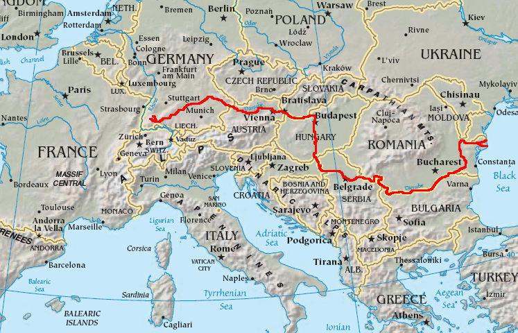
English: Map showing the flow of the Danube River. Uses the map of Europe from the CIA World Factbook.
Lisènsi
Berkas ini berada pada domain publik karena berisi material yang berasal dari The World Factbook yang dipublikasikan oleh CIA
|
 |
Sajarahing berkas
Klik ing tanggal/wektuné saprelu ndeleng rupané barkasé nalika tanggal iku.
| Tanggal/Wektu | Gambar cilik | Alang ujur | Naraguna | Tanggepan | |
|---|---|---|---|---|---|
| saiki | 12 Fèbruari 2007 05.34 | | 747 × 480 (601 KB) | Geologik | Map showing the flow of the Danube River. Uses the map of Europe from the CIA World Factbook. |
Panggunaning berkas
8 kaca ing ngisor iki nganggo barkas iki:
Panggunané barkas sajagat
Wiki liya ngisor iki nganggo barkas iki:
- Kanggo ing ang.wikipedia.org
- Kanggo ing ast.wikipedia.org
- Kanggo ing av.wikipedia.org
- Kanggo ing azb.wikipedia.org
- Kanggo ing ban.wikipedia.org
- Kanggo ing be-tarask.wikipedia.org
- Kanggo ing bg.wikipedia.org
Deleng naraguna liyané sadonya saka kaca iki.
Métadhatah
Text is available under the CC BY-SA 4.0 license; additional terms may apply.
Images, videos and audio are available under their respective licenses.
Cover photo is available under {{::mainImage.info.license.name || 'Unknown'}} license.
Cover photo is available under {{::mainImage.info.license.name || 'Unknown'}} license.
Credit:
(see original file).
