For faster navigation, this Iframe is preloading the Wikiwand page for 鬼首カルデラ.

鬼首カルデラ

鬼首カルデラの地形図

鬼首カルデラ(おにこうべカルデラ)は、宮城県大崎市栗原市秋田県湯沢市山形県最上町にまたがる直径およそ13kmカルデラである。カルデラ壁の標高はおよそ1000~1200m。荒雄岳(カルデラ内の基盤岩が隆起した山)は984.2m(最高地点はツクシ森の989m)で中央火口丘は高日向山溶岩ドーム

特徴

[編集]
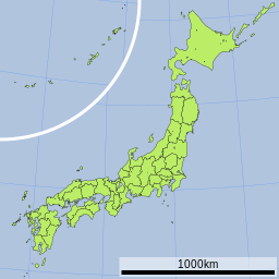
鬼首カルデラの位置(日本内)
鬼首カルデラ
鬼首の雌釜および雄釜間歇温泉

地質はデイサイト安山岩からなる。火山活動の時期は30万年~20万年前。

地理

[編集]

吹上沢および片山地獄を中心に地熱活動が認められる。片山地獄には地熱を利用した鬼首地熱発電所がある。周辺には温泉も多く、鬼首温泉、宮沢温泉、吹上温泉、轟温泉、神滝温泉などが有名。なお、鬼首の雌釜(めがま)および雄釜(おがま)間歇温泉は国の特別天然記念物に指定されているが、現在は涸れてしまっている。

カルデラには荒雄川(江合川)が流れている。カルデラの外輪山には禿岳などがある。

関連項目

[編集]


外部リンク

[編集]
{{bottomLinkPreText}} {{bottomLinkText}}
鬼首カルデラ
Listen to this article

This browser is not supported by Wikiwand :(
Wikiwand requires a browser with modern capabilities in order to provide you with the best reading experience.
Please download and use one of the following browsers:

This article was just edited, click to reload
This article has been deleted on Wikipedia (Why?)

Back to homepage

Please click Add in the dialog above
Please click Allow in the top-left corner,
then click Install Now in the dialog
Please click Open in the download dialog,
then click Install
Please click the "Downloads" icon in the Safari toolbar, open the first download in the list,
then click Install
{{::$root.activation.text}}

Install Wikiwand

Install on Chrome Install on Firefox
Don't forget to rate us

Tell your friends about Wikiwand!

Gmail Facebook Twitter Link

Enjoying Wikiwand?

Tell your friends and spread the love:
Share on Gmail Share on Facebook Share on Twitter Share on Buffer

Our magic isn't perfect

You can help our automatic cover photo selection by reporting an unsuitable photo.

This photo is visually disturbing This photo is not a good choice

Thank you for helping!


Your input will affect cover photo selection, along with input from other users.

X

Get ready for Wikiwand 2.0 🎉! the new version arrives on September 1st! Don't want to wait?