鬼ヶ岩ノ頭
| 鬼ヶ岩ノ頭 | |
|---|---|
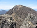
 蛭ヶ岳付近から見た鬼ヶ岩ノ頭(2007年4月撮影) | |
| 標高 | 1,608 m |
| 所在地 |
神奈川県相模原市・足柄上郡山北町 |
| 位置 | 北緯35度28分56秒 東経139度08分47秒 / 北緯35.48222度 東経139.14639度座標: 北緯35度28分56秒 東経139度08分47秒 / 北緯35.48222度 東経139.14639度 |
| 山系 | 丹沢山地 |
| 種類 | 山塊 |
 | |


鬼ヶ岩ノ頭(おにがいわの あたま/かしら)は、丹沢山地の丹沢主脈にある標高1,608mの山である。神奈川県相模原市と足柄上郡山北町との境界線上に位置し、丹沢大山国定公園に属す。
その名の通り山頂付近には鬼の角のような岩「鬼ヶ岩」がそびえ立っており、天気が良ければ鬼ヶ岩の間から雄大な蛭ヶ岳の山体を望むことができる。
丹沢山地で蛭ヶ岳(1,673m)、不動ノ峰(1,614m)に次ぎ、第三の標高を誇る。
周辺の山
[編集]周辺の山小屋
[編集]関連画像
[編集]-
 鬼ヶ岩付近は岩場となっている
 -
 鬼ヶ岩越しに見た蛭ヶ岳
 -
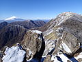


鬼ヶ岩からの眺望
[編集]
関連項目
[編集]外部リンク
[編集]
Text is available under the CC BY-SA 4.0 license; additional terms may apply.
Images, videos and audio are available under their respective licenses.
Cover photo is available under {{::mainImage.info.license.name || 'Unknown'}} license.
Cover photo is available under {{::mainImage.info.license.name || 'Unknown'}} license.
Credit:
(see original file).
