西陵古墳
| 西陵古墳 | |
|---|---|
 墳丘全景(右手前に前方部、左奥に後円部) | |
| 所属 | 淡輪古墳群 |
| 所在地 | 大阪府泉南郡岬町淡輪 |
| 位置 | 北緯34度19分37.31秒 東経135度10分8.44秒 / 北緯34.3270306度 東経135.1690111度座標: 北緯34度19分37.31秒 東経135度10分8.44秒 / 北緯34.3270306度 東経135.1690111度 |
| 形状 | 前方後円墳 |
| 規模 |
墳丘長210m 高さ約15m(後円部) |
| 埋葬施設 |
(推定)竪穴式石室 (内部に長持形石棺) |
| 出土品 | 円筒埴輪・器材埴輪など |
| 築造時期 | 5世紀前半頃 |
| 被葬者 | (推定)紀小弓 |
| 史跡 | 国の史跡「西陵古墳 第一、第二古墳」 |
| 特記事項 | 全国第28位の規模[1] |
| 地図 |
 西陵古墳 |
西陵古墳(さいりょうこふん)は、大阪府泉南郡岬町淡輪(たんのわ)にある古墳。形状は前方後円墳。淡輪古墳群を構成する古墳の1つ。国の史跡に指定されている。
名称は「西二山在古墳(にしにさんざいこふん)」とも。淡輪古墳群では最大、全国では第28位の規模の古墳で[1]、5世紀前半頃の築造とされる。
概要
[編集]大阪府の最南端、大阪湾に面した台地上に位置する巨大前方後円墳である。800メートルほど東にある淡輪ニサンザイ古墳(宮内庁治定五十瓊敷入彦命墓、墳丘長170メートル)、および淡輪ニサンザイ・西陵の中間にあった西小山古墳(円墳、非現存)などとともに淡輪古墳群を形成する。別称の「二山在(にさんざい)」は「ミササギ(陵)」の転訛。
丘陵末端を利用して築造された前方後円墳で、前方部を北東方に向ける[2]。墳丘は3段築成で、墳丘長は約210メートルを測る[2]。外部施設として、墳丘西側のくびれ部には方形の造出が設けられたほか、墳丘外表は葺石で覆われ、加えて円筒埴輪・朝顔形埴輪や、蓋形・盾形・短甲形・家形埴輪といった器材埴輪が並べられていた。墳丘周囲には幅15-35メートルの周濠が巡らされているが、周濠の元々の形は明らかでない[2]。また周濠外側には陪塚3基の存在が知られる(うち1基は消滅)[3]。
埋葬施設は明らかでないが、竪穴式石室に凝灰岩製の長持形石棺を納めていたと推測される[3]。かつては後円部墳頂において、長側辺に縄掛突起2個を有する石棺蓋石が露出していたが、国の史跡指定に伴って埋め戻されている[3]。
この西陵古墳の築造年代は、出土埴輪から5世紀前半の西暦420年-440年頃と推定されている[2]。5世紀中頃に限って築造された淡輪古墳群の大型古墳3基(西陵古墳・西小山古墳・淡輪ニサンザイ古墳)のうちでは、西小山古墳・淡輪ニサンザイ古墳に先行する。これら岬町の大型古墳群では円筒埴輪に独特の技法(淡輪技法)が見られるが、同様の技法は和歌山平野の木ノ本古墳群(和歌山市木ノ本)にも見られることから、古墳群は紀伊勢力(紀氏)との強い関わりの中で成立したと考えられている[4]。
古墳域ならびに陪塚2基は、1922年(大正11年)に国の史跡に指定されている[5]。
-
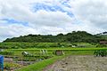 墳丘全景
墳丘全景
北西方より。左に前方部、右に後円部。 -
 後円部墳頂
後円部墳頂 -
 後円部から前方部を望む


墳丘
[編集]
国土交通省 国土地理院 地図・空中写真閲覧サービスの空中写真を基に作成
ステレオ写真はこちら
墳丘の規模は次の通り[3]。
- 墳丘長:約210メートル
- 後円部 - 3段築成。
- 直径:約115メートル
- 高さ:約18メートル
- 前方部 - 3段築成。
- 幅:約100メートル
- 高さ:約14メートル
- 造出
- 西側くびれ部:23メートル×13メートル
被葬者
[編集]被葬者は明らかでない。岬町の大型前方後円墳2基はいずれも当地の経済力のみで築造されたと考えにくいことから、これらの築造において紀伊勢力(紀氏)の関与が想定される[6]。
一説では、被葬者は『日本書紀』雄略天皇9年3月条・5月条に見える5世紀後半の将軍の紀小弓(きのおゆみ、紀小弓宿禰)に比定される。『日本書紀』によると、紀小弓は新羅征討の将軍に任じられて戦ったが、病気により新羅で亡くなった。そこで天皇は土師連小鳥に命じて、「田身輪邑(たむわのむら)」に紀小弓の墓を造らせたという。西陵古墳がこの紀小弓の墓に比定されるのは、その「田身輪」が「淡輪」に比定されることによる[7]。
そのほか、『和泉志』では紀船守の墓とする説を挙げ、『泉州志』では西陵古墳・宇度墓古墳のどちらか一方を紀小弓の墓としてもう一方を紀船守の墓とする説を挙げる[8]。ただし、この紀船守は8世紀の人物(731年-792年)になる。また『南游紀行』では五十瓊敷入彦命とする説を挙げている。
陪塚
[編集]西陵古墳の北方には第一古墳(北緯34度19分43.99秒 東経135度10分7.34秒 / 北緯34.3288861度 東経135.1687056度)、第二古墳(北緯34度19分45.31秒 東経135度10分6.97秒 / 北緯34.3292528度 東経135.1686028度)の円墳2基があり、いずれも西陵古墳の陪塚とされる[3]。これらは西陵古墳とともに国の史跡に指定されている。
なお、かつては陪塚と見られる古墳がもう1基存在したが、線路の敷設時に破壊された。その際に提瓶2個、高坏1個、壺2個、平瓶1個、刀身断片、鉄鏃2本が出土したという。
-
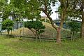 第一古墳
第一古墳 -
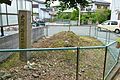 第二古墳
第二古墳


文化財
[編集]国の史跡
[編集]- 西陵古墳 第一、第二古墳 - 大正11年3月8日指定[5]。
脚注
[編集]- ^ a b 古墳大きさランキング(日本全国版)(堺市ホームページ、2018年5月13日更新版)。
- ^ a b c d 岬町の歴史 & 1995年, pp. 45–47.
- ^ a b c d e 西陵古墳(平凡社) & 1986年.
- ^ 岬町の歴史 & 1995年, pp. 51–52.
- ^ a b 西陵古墳 第一、第二古墳 - 国指定文化財等データベース(文化庁)
- ^ 岬町の歴史 & 1995年, pp. 67–68.
- ^ 史跡説明板。
- ^ 岬町の歴史 & 1995年, pp. 69–70.
参考文献
[編集]- 史跡説明板(岬町教育委員会設置)
- 『大阪府史蹟名勝天然紀念物調査報告 第三輯』 大阪府、1932年。
- 「淡輪古墳群」『角川日本地名大辞典 27 大阪府』角川書店、1983年。ISBN 978-4040012704。
- 『日本歴史地名大系 28-2 大阪府の地名』平凡社、1986年。ISBN 978-4582490282。
- 「泉南郡」、「西陵古墳」。
- 『岬町の歴史』岬町、1995年。
関連項目
[編集]外部リンク
[編集]- 西陵古墳 第一、第二古墳 - 国指定文化財等データベース(文化庁)
- 遺跡・旧跡 > 西陵古墳 - 岬町ホームページ
Text is available under the CC BY-SA 4.0 license; additional terms may apply.
Images, videos and audio are available under their respective licenses.
