For faster navigation, this Iframe is preloading the Wikiwand page for 狭間峠.

狭間峠

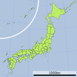
狭間峠の位置(日本内)
狭間峠
狭間峠
京都府道366号標識

狭間峠(はざまとうげ)は、京都府京都市右京区に在る

概要

[編集]

標高310mの京都府道366号上に位置する峠である。現在京都市右京区京北下弓削町と同区京北塔町を隔てている。名前の由来は盆地であるこの地域の、峠と反対側の尾根から山際を眺めた際、この峠の尾根がV字に凹んでおり、これを狭間と呼んだとの伝承が残っている。周囲の他の峠よりも100mほど標高が低く、越えやすい峠として現在でもなおその名が残っている。峠を示すものは残っていないが、周山地区を見渡すことができる峠である。

道路状況

[編集]

車両での通行が可能な峠である。勾配やカーブこそ急だが、標高が低く山道の区間が短いため、比較的緩やかな峠である。京都府道366号上に位置しており、この路線は国道162号国道477号を結ぶ役割を担っているが、この両国道はすぐ近くで接続しており迂回の必要がない限り利用の少ない路線である。これに伴ってこの峠自体も交通量が少なく、静かな雰囲気を保っている。

隣接する峠

[編集]

関連項目

[編集]
{{bottomLinkPreText}} {{bottomLinkText}}
狭間峠
Listen to this article

This browser is not supported by Wikiwand :(
Wikiwand requires a browser with modern capabilities in order to provide you with the best reading experience.
Please download and use one of the following browsers:

This article was just edited, click to reload
This article has been deleted on Wikipedia (Why?)

Back to homepage

Please click Add in the dialog above
Please click Allow in the top-left corner,
then click Install Now in the dialog
Please click Open in the download dialog,
then click Install
Please click the "Downloads" icon in the Safari toolbar, open the first download in the list,
then click Install
{{::$root.activation.text}}

Install Wikiwand

Install on Chrome Install on Firefox
Don't forget to rate us

Tell your friends about Wikiwand!

Gmail Facebook Twitter Link

Enjoying Wikiwand?

Tell your friends and spread the love:
Share on Gmail Share on Facebook Share on Twitter Share on Buffer

Our magic isn't perfect

You can help our automatic cover photo selection by reporting an unsuitable photo.

This photo is visually disturbing This photo is not a good choice

Thank you for helping!


Your input will affect cover photo selection, along with input from other users.

X

Get ready for Wikiwand 2.0 🎉! the new version arrives on September 1st! Don't want to wait?