明月町
明月町 | |
|---|---|
 名古屋柳城短期大学 | |
 明月町 明月町の位置  明月町 明月町 (名古屋市) | |
| 北緯35度8分49.53秒 東経136度55分49.47秒 / 北緯35.1470917度 東経136.9304083度 | |
| 国 |
|
| 都道府県 |
|
| 市町村 |
|
| 区 | 昭和区 |
| 町名制定[1] | 1933年(昭和8年)9月20日 |
| 面積 | |
| • 合計 | 0.07528577 km2 |
| 人口 | |
| • 合計 | 746人 |
| • 密度 | 9,900人/km2 |
| 等時帯 | UTC+9 (日本標準時) |
| 郵便番号 |
466-0034[WEB 3] |
| 市外局番 | 052 (名古屋MA)[WEB 4] |
| ナンバープレート | 名古屋 |
明月町(めいげつちょう)は、愛知県名古屋市昭和区の地名。現行行政地名は明月町1丁目から明月町3丁目[WEB 1]。住居表示未実施地域[WEB 5]。
地理
[編集]名古屋市昭和区中央西部に位置する[2]。
歴史
[編集]沿革
[編集]- 1933年(昭和8年)9月20日 - 中区御器所町および同区広路町の各一部により、同区明月町として成立[1]。
- 1937年(昭和12年)10月1日 - 昭和区成立により、同区明月町となる[1]。
- 1950年(昭和25年)7月15日 - 一部が昭和区石仏町に編入される[3]。
世帯数と人口
[編集]2019年(平成31年)1月1日現在の世帯数と人口は以下の通りである[WEB 2]。
| 町丁 | 世帯数 | 人口 |
|---|---|---|
| 明月町 | 354世帯 | 746人 |
人口の変遷
[編集]国勢調査による人口の推移
| 1995年(平成7年) | 788人 | [WEB 6] | |
| 2000年(平成12年) | 774人 | [WEB 7] | |
| 2005年(平成17年) | 788人 | [WEB 8] | |
| 2010年(平成22年) | 784人 | [WEB 9] | |
| 2015年(平成27年) | 757人 | [WEB 10] |
学区
[編集]市立小・中学校に通う場合、学校等は以下の通りとなる[WEB 11]。また、公立高等学校に通う場合の学区は以下の通りとなる[WEB 12]。
| 丁目 | 番・番地等 | 小学校 | 中学校 | 高等学校 |
|---|---|---|---|---|
| 明月町1丁目 | 全域 | 名古屋市立御器所小学校 | 名古屋市立桜山中学校 | 尾張学区 |
| 明月町2丁目 | 全域 | |||
| 明月町3丁目 | 全域 | 名古屋市立松栄小学校 |
施設
[編集]
-
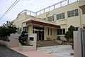 名古屋市立御器所小学校
 -
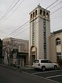 名古屋聖マタイ教会


その他
[編集]日本郵便
[編集]脚注
[編集]WEB
[編集]- ^ a b “愛知県名古屋市昭和区の町丁・字一覧”. 人口統計ラボ. 2017年5月21日閲覧。
- ^ a b “町・丁目(大字)別、年齢(10歳階級)別公簿人口(全市・区別)”. 名古屋市 (2019年1月23日). 2019年1月23日閲覧。
- ^ a b “郵便番号”. 日本郵便. 2019年1月6日閲覧。
- ^ “市外局番の一覧”. 総務省. 2019年1月6日閲覧。
- ^ 名古屋市役所市民経済局地域振興部住民課町名表示係 (2015年10月21日). “昭和区の町名”. 名古屋市. 2017年5月21日閲覧。
- ^ 総務省統計局 (2014年3月28日). “平成7年国勢調査の調査結果(e-Stat) - 男女別人口及び世帯数 -町丁・字等” (CSV). 2019年4月27日閲覧。
- ^ 総務省統計局 (2014年5月30日). “平成12年国勢調査の調査結果(e-Stat) - 男女別人口及び世帯数 -町丁・字等” (CSV). 2019年4月27日閲覧。
- ^ 総務省統計局 (2014年6月27日). “平成17年国勢調査の調査結果(e-Stat) - 男女別人口及び世帯数 -町丁・字等” (CSV). 2019年4月27日閲覧。
- ^ 総務省統計局 (2012年1月20日). “平成22年国勢調査の調査結果(e-Stat) - 男女別人口及び世帯数 -町丁・字等” (CSV). 2019年4月27日閲覧。
- ^ 総務省統計局 (2017年1月27日). “平成27年国勢調査の調査結果(e-Stat) - 男女別人口及び世帯数 -町丁・字等” (CSV). 2019年4月27日閲覧。
- ^ “市立小・中学校の通学区域一覧”. 名古屋市 (2018年11月10日). 2019年1月14日閲覧。
- ^ “平成29年度以降の愛知県公立高等学校(全日制課程)入学者選抜における通学区域並びに群及びグループ分け案について”. 愛知県教育委員会 (2015年2月16日). 2019年1月14日閲覧。
- ^ 郵便番号簿 平成29年度版 - 日本郵便. 2019年01月06日閲覧 (PDF)
書籍
[編集]- ^ a b c 名古屋市計画局 1992, p. 797.
- ^ 「角川日本地名大辞典」編纂委員会 1989, p. 1460.
- ^ 名古屋市計画局 1992, p. 796.
- ^ a b c 「角川日本地名大辞典」編纂委員会 1989, p. 1461.
参考文献
[編集]- 「角川日本地名大辞典」編纂委員会 編『角川日本地名大辞典 23 愛知県』角川書店、1989年3月8日。ISBN 4-04-001230-5。
- 名古屋市計画局『なごやの町名』名古屋市計画局、1992年3月31日。
関連項目
[編集]外部リンク
[編集] ウィキメディア・コモンズには、明月町に関するカテゴリがあります。
| あ行 | |
|---|---|
| か行 | |
| さ行 | |
| た行 | |
| な行 | |
| は行 | |
| ま行 | |
| や行 | |
| ら・わ行 | |
| 註 |
|
| 旧町名 | |
|
| |
Text is available under the CC BY-SA 4.0 license; additional terms may apply.
Images, videos and audio are available under their respective licenses.
Cover photo is available under {{::mainImage.info.license.name || 'Unknown'}} license.
Cover photo is available under {{::mainImage.info.license.name || 'Unknown'}} license.
Credit:
(see original file).
