For faster navigation, this Iframe is preloading the Wikiwand page for 播磨灘.

播磨灘

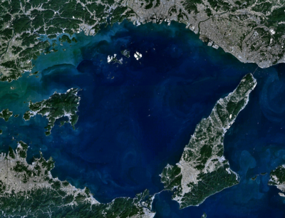
播磨灘(はりまなだ)は、瀬戸内海東部の海域兵庫県南西部(旧播磨国)の南側に位置し、東は淡路島、西は小豆島、南は四国で区切られて西北部に家島諸島がある。

地理

[編集]

面積約2500 km2。深さ40 m前後であるが、海峡部では100 mを越えるところもある。大阪湾の西の延長で近畿地方から中国地方・四国地方・九州地方方面への重要な航路が横断する。

播磨灘北東部には明石海峡の西側から南西方向に伸びる「鹿ノ瀬」と呼ばれる浅瀬(水深5〜30m)があり、東西約20㎞、南北約5㎞の範囲で広がっている[1]

岩礁が多く、などの好漁場。イカナゴもよく獲れ、イカナゴの釘煮(佃煮)は播州の特産品であったが、海砂の採取によってイカナゴの生息地が打撃を受けたことから減産している[2]

ランドサット7号 (Landsat 7) が撮影した播磨灘。
※表示環境によっては文字がずれることがあります。

播磨灘に流れ込む主な川

[編集]

播磨灘にある港町

[編集]

工業港湾

[編集]

播磨灘に面する島

[編集]

播磨灘に面する自治体

[編集]

脚注

[編集]

関連項目

[編集]
{{bottomLinkPreText}} {{bottomLinkText}}
播磨灘
Listen to this article

This browser is not supported by Wikiwand :(
Wikiwand requires a browser with modern capabilities in order to provide you with the best reading experience.
Please download and use one of the following browsers:

This article was just edited, click to reload
This article has been deleted on Wikipedia (Why?)

Back to homepage

Please click Add in the dialog above
Please click Allow in the top-left corner,
then click Install Now in the dialog
Please click Open in the download dialog,
then click Install
Please click the "Downloads" icon in the Safari toolbar, open the first download in the list,
then click Install
{{::$root.activation.text}}

Install Wikiwand

Install on Chrome Install on Firefox
Don't forget to rate us

Tell your friends about Wikiwand!

Gmail Facebook Twitter Link

Enjoying Wikiwand?

Tell your friends and spread the love:
Share on Gmail Share on Facebook Share on Twitter Share on Buffer

Our magic isn't perfect

You can help our automatic cover photo selection by reporting an unsuitable photo.

This photo is visually disturbing This photo is not a good choice

Thank you for helping!


Your input will affect cover photo selection, along with input from other users.

X

Get ready for Wikiwand 2.0 🎉! the new version arrives on September 1st! Don't want to wait?