For faster navigation, this Iframe is preloading the Wikiwand page for 抜海岬.

抜海岬

座標: 北緯45度18分41秒 東経141度36分53秒 / 北緯45.311480度 東経141.614805度 / 45.311480; 141.614805

抜海港内のゴマフアザラシ
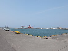
抜海漁港の様子(2015年4月)

抜海岬(ばっかいみさき)は、北海道稚内市抜海村にある、日本海(利尻水道)に面した。長さ約600m。

概要

[編集]

稚内市域の南西部に位置し、はるかに利尻島が望まれる。また、付近の丘からは海岸砂丘の列を眺めることができる。冬季には地吹雪が激しい。

岬の南側に抜海漁港があり、岬の大半は同港の岸壁となっている。冬季に稚内港流氷で使用不能となった際、ここから利尻島礼文島へ定期船が発着することもある。冬季には港近くの岩礁で、流氷に乗ってやって来たゴマフアザラシを見ることができる。

地名の由来

[編集]

周辺

[編集]
  • 抜海原生花園
  • 抜海駅
  • 抜海郵便局
  • 稚内市立抜海小中学校(2007年3月廃校)

アクセス

[編集]

外部リンク

[編集]
{{bottomLinkPreText}} {{bottomLinkText}}
抜海岬
Listen to this article

This browser is not supported by Wikiwand :(
Wikiwand requires a browser with modern capabilities in order to provide you with the best reading experience.
Please download and use one of the following browsers:

This article was just edited, click to reload
This article has been deleted on Wikipedia (Why?)

Back to homepage

Please click Add in the dialog above
Please click Allow in the top-left corner,
then click Install Now in the dialog
Please click Open in the download dialog,
then click Install
Please click the "Downloads" icon in the Safari toolbar, open the first download in the list,
then click Install
{{::$root.activation.text}}

Install Wikiwand

Install on Chrome Install on Firefox
Don't forget to rate us

Tell your friends about Wikiwand!

Gmail Facebook Twitter Link

Enjoying Wikiwand?

Tell your friends and spread the love:
Share on Gmail Share on Facebook Share on Twitter Share on Buffer

Our magic isn't perfect

You can help our automatic cover photo selection by reporting an unsuitable photo.

This photo is visually disturbing This photo is not a good choice

Thank you for helping!


Your input will affect cover photo selection, along with input from other users.

X

Get ready for Wikiwand 2.0 🎉! the new version arrives on September 1st! Don't want to wait?