庵原川
| 庵原川 | |
|---|---|
 | |
| 水系 | 二級水系 庵原川 |
| 種別 | 二級河川 |
| 延長 | 6.7 km |
| 流域面積 | 21.9 km² |
| 水源 | 庵原山地 |
| 河口・合流先 | 清水港 |
| 流域 | 静岡県静岡市 |
 | |
概要
庵原川は静岡市清水区伊佐布の高山(標高836m)に源を発し、支川の山切川を合わせ、清水港の袖師埠頭わきで太平洋に注ぐ二級河川[1]。流域面積は約21.9km²、流路延長6.7kmである[1]。
上流域には庵原山地があり大起伏山地または小起伏山地に分類され、下流域には清水平野が広がっており扇状地性低地に分類される[1]。
災害
流域
源流付近には今から約800年前、真言宗の修行の場として開かれたと言われる伊佐布(いさぶ)北滝がある。 下流の新明川合流点付近には、昭和49年に地元住民によって植えられた70本の桜が並んでいる。[2]
-
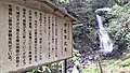 伊佐布北滝とその案内板(2022年8月撮影)
 -
 庵原川起点(静岡市清水区伊佐布 2022年8月撮影)
 -
 山切川起点(静岡市清水区吉原 2022年8月撮影)
 -
 山切川中流(静岡市清水区杉山 2022年8月撮影)
 -
 庵原川(左)と山切川(右)の合流点(静岡市清水区尾羽 2020年8月撮影)
 -
 庵原川と神明川の合流点(静岡市清水区袖師町 2022年4月撮影)
 -
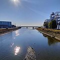 静岡市清水区横砂南 一葉橋より庵原川河口を望む(2022年10月撮影)


出典
- ^ a b c d e f g “庵原川水系河川整備基本方針”. 静岡県. 2022年11月14日閲覧。
- ^ “しずおか河川ナビゲーション 庵原川水系”. 静岡県. 2023年1月14日閲覧閲覧。
Text is available under the CC BY-SA 4.0 license; additional terms may apply.
Images, videos and audio are available under their respective licenses.
Cover photo is available under {{::mainImage.info.license.name || 'Unknown'}} license.
Cover photo is available under {{::mainImage.info.license.name || 'Unknown'}} license.
Credit:
(see original file).
