宮戸島
| 宮戸島 | |
|---|---|
 松島丘陵東端周辺の空撮。写真中央にある宮戸島は、写真左から延びる七ヶ浜と共に松島湾の湾口を形成する。 | |
| 所在地 | 日本 |
| 所在海域 | 太平洋、仙台湾、松島湾 |
| 座標 | 北緯38度20分7.1秒 東経141度9分14秒 / 北緯38.335306度 東経141.15389度 |
| 面積 | 7.39 km² |
| 海岸線長 | 約15 km |
| 最高標高 | 105.6 m |
| 最高峰 | 大高森 |
 宮戸島 宮戸島 (宮城県)  宮戸島 宮戸島 (日本) | |

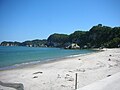
宮戸島(みやとじま)は、宮城県東松島市にある島である。仙台湾の支湾である松島湾と石巻湾とを分ける位置にある。島の周囲約12キロメートル、面積約8平方キロメートル[1][2]。島としては、松島湾で最大である。人口は約1,200人。日本三景松島の観光においては「奥松島」と言われる地区で、松島四大観の一つ「壮観」と称される眺望を得られる大高森や、波風によって浸食された荒々しい海食崖の嵯峨渓がある。砂の堆積により野蒜海岸と繋がり陸繋島となっていた時期があったが、昭和中期に潜ヶ浦(かつぎがうら)水道の開削が行われ、再び野蒜海岸とは分離された。潜ヶ浦水道には松ヶ島橋が架かり、島と本土を結んでいる。
地理
[編集]現在の宮戸島は野蒜海岸[座標 1]の南端にあり、野蒜海岸を陸繋砂州とする陸繋島に近い地形だが、野蒜海岸とは潜ヶ浦水道[座標 2][3]によって分断されている。これらを結んでいるのが松ヶ島橋[座標 3]であり、ここを宮城県道27号奥松島松島公園線が通っている。宮戸島の西側にある浦戸諸島の寒風沢島[座標 4]とは、幅80メートルの鰐ヶ渕水道[座標 5]を挟んで向かい合っている。
島の気候は温暖で、ツバキなどの暖地性の植物と寒地性の植物が共存する珍しい場所でもある。島のほとんどは山地で、平地は少なく、海岸線が入り組んでいる。
大高森
[編集]島の最高峰は標高106メートルの大高森[4][座標 6]である。この山頂からは仙台湾およびその内湾である松島湾と石巻湾、牡鹿半島、蔵王連峰、栗駒山を望むことができ、松島四大観の一つに数えられ「壮観」と呼ばれる。
嵯峨渓
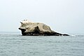
[編集]島の東南端にある萱野崎に向かう岬は「嵯峨渓」と呼ばれている[座標 7]。「めがね島」や「かえる島」など多数の名岩や奇岩が連なり、岩手県の猊鼻渓、大分県の耶馬渓と並ぶ「日本三大渓」の1つである。遊歩百選に選ばれている。
-
 室浜より嵯峨渓を望む
 -
 めがね島
めがね島 -
 かえる島
かえる島


潜ヶ浦における砂の堆積と水道の開削
[編集]江戸時代では、鳴瀬川河口付近より南側にある不老山[座標 8]、鷺ノ巣岩[座標 9]、鰯山[座標 10]、宮戸島などは全て島であり、多島海の風景だった[5][6][7][8][9][10]。しかし、この海域の北東にある石巻湾の海岸付近では、波の影響で旧北上川等から供給される砂が海岸沿いを東から西へ移動する傾向があり、さらに鳴瀬川の流出土砂も加わって、特に鳴瀬川河口から宮戸島までの間に砂が堆積した[6]。これにより、不老山、鷺ノ巣岩、鰯山などは陸封され、それらより海側には野蒜海岸(洲崎浜)という広大な砂嘴の砂浜が形成された[6]。
宮戸島は明治時代までは島であり、対岸との海域は潜ヶ浦と呼ばれていた。しかし、潜ヶ浦において土砂の堆積が進むと、野蒜海岸が宮戸島へ徐々に延びて両者が繋がった。1934年(昭和9年)には野蒜から宮戸島まで道路が開通した[1]。それまでは野蒜と宮戸島の間の人の往来手段は主に渡し舟によるものだった[2]。
戦後、宮戸島と野蒜海岸との間に潜ヶ浦水道を開削するよう第12回国会衆議院運輸委員会に請願書が提出され、1951年(昭和26年)11月27日に審議された[11]。1963年度(昭和38年度)から1965年度(昭和40年度)の3年にわたって、潜ヶ浦水道の開削やそれを渡る松ヶ島橋(45メートル)の架橋などが事業費約1億6千万円をかけて行われ、島と陸繋砂州の野蒜海岸は分離された[12]。また、二本松鼻[座標 11]と呼ばれる細長い岬が、潜ヶ浦水道の開削により宮戸島から切り離された[5]。
歴史
[編集]最終氷期には松島湾は全て陸地であり宮戸島も地続きだったが、現在から8900年前には縄文海進により大仏山[座標 12]側の松島丘陵との間に海が侵入して松島湾が形成され始めた[5]。さらに8700年前には、宮戸島と浦戸諸島などが1つの島として当時の松島湾内に浮かぶ形となった[5]。当初、丸山[座標 13]は宮戸島と浦戸諸島などが一体となった島の一部であったが、6800年前には分離して大仏山側と陸続きとなった[5]。
宮戸島には縄文時代から人が住んだ痕跡が残る。里浜貝塚は日本全国でみても大きな貝塚で、1918年(大正7年)に縄文時代の人骨が14体発見され、当時、黎明期にあった日本の古人骨研究を活気付けた[13]。この時、またその後の調査でさらに多くの人骨を含むおびただしい遺物が発掘され、特に出土した縄文後期土器に基づく「宮戸島編年」はその後も縄文土器編年の指標の一つとなっている。東北歴史資料館の発掘調査を経て、1995年(平成7年)に国の史跡に指定された。
第二次世界大戦中には特攻兵器「震洋」の基地が建設され、現在でも格納壕が残っている[14]。
行政区画に関しては、1889年(明治22年)の町村制施行時は桃生郡宮戸村に属していたが、1955年(昭和30年)の市町村合併により桃生郡鳴瀬町となり、2005年(平成17年)より東松島市の市域となっている。
生活
[編集]- 学校 - 島内に東松島市立宮戸小学校が存在したが、2016年(平成28年)4月1日に島外の宮野森小学校へ統合された。
- 郵便局 - 宮戸郵便局がある。
- 医療 - 島内に医院がある。
- 通信- 電話は本土と同様に利用可能。宮城県で放送されている全てのテレビ・ラジオ放送局の電波が問題なく受信できる。
- 民宿 - かつては100軒近くの民宿があったが、現在は10軒を下回っている。
交通
[編集]宮城県道27号奥松島松島公園線(奥松島パークライン)によって、本州との陸上交通が確立されている。宮城県道27号は宮戸島内では、月浜地区を経由して室浜地区に至っている[15]。
現在、島には公共交通機関はなく、陸路ではJR仙石線・野蒜駅からのタクシー、海路では松島港から観光船、あるいはプレジャーボートでアプローチする形になる。かつては仙北鉄道がバスを運行していたが、その後宮城交通となり、1997年(平成9年)9月30日をもって廃止された。
松ヶ島橋の北詰(野蒜海岸側)の潜ヶ浦水道沿いに、嵯峨渓遊覧船の案内所、桟橋、客用の無料駐車場がある。
脚注
[編集]座標
[編集]- ^ 北緯38度22分11.1秒 東経141度9分54.4秒 / 北緯38.369750度 東経141.165111度
- ^ 西端~東端
- ^ 北緯38度21分14.2秒 東経141度9分24.7秒 / 北緯38.353944度 東経141.156861度
- ^ 北緯38度20分12.1秒 東経141度7分32.5秒 / 北緯38.336694度 東経141.125694度
- ^ 北緯38度20分18.3秒 東経141度7分51.3秒 / 北緯38.338417度 東経141.130917度
- ^ 北緯38度20分26.2512秒 東経141度09分08.8728秒
- ^ 北緯38度19分22.8秒 東経141度10分47.6秒 / 北緯38.323000度 東経141.179889度
- ^ 北緯38度22分26.9秒 東経141度10分7秒 / 北緯38.374139度 東経141.16861度
- ^ 北緯38度22分22.2秒 東経141度9分59.7秒
- ^ 北緯38度22分12.1秒 東経141度9分36.6秒
- ^ 北緯38度21分19秒 東経141度9分49.7秒 / 北緯38.35528度 東経141.163806度
- ^ 北緯38度22分31.3秒 東経141度8分38.3秒 / 北緯38.375361度 東経141.143972度
- ^ 北緯38度21分42.5秒 東経141度8分7.2秒 / 北緯38.361806度 東経141.135333度
出典
[編集]- ^ a b 『角川日本地名大辞典4 宮城県』512頁。
- ^ a b 『宮城県の地名』604-605頁。
- ^ 潜ヶ浦地区位置図 (PDF) (宮城県石巻港湾事務所「潜ヶ浦地区海域環境対策コラボ事業懇談会資料」 2008年2月15日)
- ^ 宮城県の主な山岳標高(国土交通省国土地理院)
- ^ a b c d e 野蒜海岸付近の砂移動と地形変化 (PDF) (宮城県石巻港湾事務所「潜ヶ浦地区海域環境対策コラボ事業懇談会」 2008年10月17日)
- ^ a b c 潜ヶ浦コラボ通信 (PDF) (宮城県石巻港湾事務所「潜ヶ浦地区海域環境対策コラボ事業懇談会」作業部会 2008年12月1日)
- ^ 仙台領分図(宮城県図書館「古絵地図」。年代:1670年(寛文10年)- 1678年(延宝6年))
- ^ 仙台領国絵図(宮城県図書館「古絵地図」。年代:1701年(元禄14年))
- ^ 御領分絵図(宮城県図書館「古絵地図」。年代不明)
- ^ 御領分絵図(宮城県図書館「古絵地図」。年代:1865年(慶応元年))
- ^ 第012回国会 第14号 昭和26年11月27日(衆議院会議録情報)
- ^ 潜ヶ浦水道について「潜ヶ浦浚渫掘削事業と松島湾浅海漁場開発事業計画」 (PDF) (宮城県 1968年10月)
- ^ 『宮城県史』復刻版第1巻(古代・中世)、23-24頁。
- ^ 戦争の記憶 東松島に特攻兵器「震洋」の基地跡 格納壕10個 - 河北新報
- ^ “地理院地図|国土地理院”. maps.gsi.go.jp. 2020年2月22日閲覧。
参考文献
[編集]- 角川日本地名大辞典編纂委員会 『角川日本地名大辞典4 宮城県』 角川書店、1979年。
- 平凡社地方資料センター 『宮城県の地名』(日本歴史地名大系第4巻) 平凡社、1987年。
関連項目
[編集]外部リンク
[編集]- 奥松島縄文村歴史資料館
- 仙台湾貝塚の基礎的研究―後藤勝彦の考古学―
- 東松島タウンガイド「観光みどころ情報」(東松島市商工会)
- 奥松島の旅(奥松島公社)
Text is available under the CC BY-SA 4.0 license; additional terms may apply.
Images, videos and audio are available under their respective licenses.
