全ての座標を示した地図 -
OSM
全座標を出力 -
KML
.mw-parser-output .hlist ul,.mw-parser-output .hlist ol{padding-left:0}.mw-parser-output .hlist li,.mw-parser-output .hlist dd,.mw-parser-output .hlist dt{margin-right:0;display:inline-block;white-space:nowrap}.mw-parser-output .hlist dt:after,.mw-parser-output .hlist dd:after,.mw-parser-output .hlist li:after{white-space:normal}.mw-parser-output .hlist li:after,.mw-parser-output .hlist dd:after{content:" ·\a0 ";font-weight:bold}.mw-parser-output .hlist dt:after{content:": "}.mw-parser-output .hlist-pipe dd:after,.mw-parser-output .hlist-pipe li:after{content:" |\a0 ";font-weight:normal}.mw-parser-output .hlist-hyphen dd:after,.mw-parser-output .hlist-hyphen li:after{content:" -\a0 ";font-weight:normal}.mw-parser-output .hlist-comma dd:after,.mw-parser-output .hlist-comma li:after{content:"、";font-weight:normal}.mw-parser-output .hlist-slash dd:after,.mw-parser-output .hlist-slash li:after{content:" /\a0 ";font-weight:normal}.mw-parser-output .hlist dd:last-child:after,.mw-parser-output .hlist dt:last-child:after,.mw-parser-output .hlist li:last-child:after{content:none}.mw-parser-output .hlist dd dd:first-child:before,.mw-parser-output .hlist dd dt:first-child:before,.mw-parser-output .hlist dd li:first-child:before,.mw-parser-output .hlist dt dd:first-child:before,.mw-parser-output .hlist dt dt:first-child:before,.mw-parser-output .hlist dt li:first-child:before,.mw-parser-output .hlist li dd:first-child:before,.mw-parser-output .hlist li dt:first-child:before,.mw-parser-output .hlist li li:first-child:before{content:" (";font-weight:normal}.mw-parser-output .hlist dd dd:last-child:after,.mw-parser-output .hlist dd dt:last-child:after,.mw-parser-output .hlist dd li:last-child:after,.mw-parser-output .hlist dt dd:last-child:after,.mw-parser-output .hlist dt dt:last-child:after,.mw-parser-output .hlist dt li:last-child:after,.mw-parser-output .hlist li dd:last-child:after,.mw-parser-output .hlist li dt:last-child:after,.mw-parser-output .hlist li li:last-child:after{content:")\a0 ";font-weight:normal}.mw-parser-output .hlist ol{counter-reset:listitem}.mw-parser-output .hlist ol>li{counter-increment:listitem}.mw-parser-output .hlist ol>li:before{content:" "counter(listitem)" ";white-space:nowrap}.mw-parser-output .hlist dd ol>li:first-child:before,.mw-parser-output .hlist dt ol>li:first-child:before,.mw-parser-output .hlist li ol>li:first-child:before{content:" ("counter(listitem)" "}.mw-parser-output .navbar{display:inline;font-size:75%;font-weight:normal}.mw-parser-output .navbar-collapse{float:left;text-align:left}.mw-parser-output .navbar-boxtext{word-spacing:0}.mw-parser-output .navbar ul{display:inline-block;white-space:nowrap;line-height:inherit}.mw-parser-output .navbar-brackets::before{margin-right:-0.125em;content:"[ "}.mw-parser-output .navbar-brackets::after{margin-left:-0.125em;content:" ]"}.mw-parser-output .navbar li{word-spacing:-0.125em}.mw-parser-output .navbar-mini abbr{font-variant:small-caps;border-bottom:none;text-decoration:none;cursor:inherit}.mw-parser-output .navbar-ct-full{font-size:114%;margin:0 7em}.mw-parser-output .navbar-ct-mini{font-size:114%;margin:0 4em}.mw-parser-output .infobox .navbar{font-size:88%}.mw-parser-output .navbox .navbar{display:block;font-size:88%}.mw-parser-output .navbox-title .navbar{float:left;text-align:left;margin-right:0.5em}
表示
太白山 (たいはくさん)は、宮城県 仙台市 太白区 茂庭にある山である。山頂部にある三等三角点 「生出森」の標高 は320.61メートル (2014年4月1日)[1] 仙台富士 [3] 名取富士 [4] [5]
太白山はかつては「独活(うど)ヶ森」「おどが森」「生出 森」と呼ばれていた[6] 金星 )が落ちて出来た山」という伝承に由来する[6]
この言い伝えについて言及した古い文献として、江戸時代 に仙台藩 の儒学者 佐久間洞巖 が著した地誌『奥羽観蹟聞老志』がある。この地誌は、この山に巨人や仙人がいたとする伝説も紹介している。また、太白山の名は、中国の王朝唐 の都長安 の西に位置する道教 の聖地「太白峰」になぞらえたものでもあるという。ただ、江戸時代の絵図ではこの山は「ウトガ森」と表されていた。太白山という呼び名が定着するのは明治時代以降だろうと考えられている[3]
太白山は仙台市周辺の平野部の広い範囲から眺められる[7] 縄文時代 から人々の親しみと信仰の対象となってきたと考えられており、平安時代 初期の大同 2年(807年 )には山頂に貴船神社 (北緯38度14分5.8秒 東経140度48分7.6秒 / 北緯38.234944度 東経140.802111度 / 38.234944; 140.802111 (貴船神社 ) 奥州合戦 最中の文治 5年(1189年 )には源頼朝 が鶴岡八幡宮 勧請した生出森八幡神社(岳宮 里宮 [6] [7] 千石船 がこの山を航海における目印の一つとして見ていたと伝わる。また、閖上 周辺の漁業では太白山を基準の一つとして漁場の確認を行っていたという[3]
太白山の入口は茂庭台入口と人来田団地入口の二箇所がある。また、太白団地からは自然観察の森経由で登山口に行くことができる。すべて車での乗り入れが可能であり、生出森八幡神社の鳥居前には駐車場もある。山頂への道は、鳥居をくぐり、生出森八幡神社を経由して、山の東側から岩場の急傾斜を登る。山頂から北東方向に伸びる尾根に出ると傾斜が緩み、すぐに山頂に至る。なお、鳥居前の駐車場から少し西側に寄ったところに、もう一つの登山道の入り口がある。こちらは獣道に近い状態で、山頂直下から西南方向に伸びる尾根を登っている。歩く人は少ないが、ワイルドな趣があり、カモシカ を見かけることもある。山頂直下はかなりの急傾斜になり、手がかり足がかりを求めて登ることになる。山頂の貴船神社の祠のすぐ横に出る。
宮城県道31号仙台村田線 茂庭台北入口交差点手前やまびこ幼稚園前
中腹にある生出森八幡神社
山頂直下の鎖場
山頂の貴船神社
山頂から見た茂庭台
見晴らし道から見た太白山
東側の山麓には仙台市管理の「太白山自然観察の森」(北緯38度14分20.9秒 東経140度48分51.5秒 / 北緯38.239139度 東経140.814306度 / 38.239139; 140.814306 (太白山自然観察の森 )
太白山麓(仙台市道茂庭佐保山線)は国道286号 線の裏道として高校生などの地元住民に利用されている。砂利道ではあるものの車一台分の通行スペースはあり、茂庭台 と太白団地を結んでいる。ただし、きちんと整備されている道路ではないため冬場は積雪により通行不能となることもしばしばある。
仙台市史編さん委員会 『仙台市史』特別編9(地域史) 仙台市、2014年。
角川日本地名大辞典編纂委員会 『角川日本地名大辞典4 宮城県』 角川書店、1979年。
平凡社地方資料センター 『宮城県の地名』(日本歴史地名大系第4巻) 平凡社、1987年。 


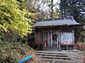 中腹にある生出森八幡神社
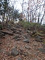 山頂直下の鎖場
 山頂の貴船神社
 山頂から見た茂庭台
 見晴らし道から見た太白山


