三ヶ根山
| 三ヶ根山 | |
|---|---|
 | |
| 標高 | 321 m |
| 所在地 |
愛知県額田郡幸田町・ 西尾市・蒲郡市 |
| 位置 | 北緯34度48分57.90秒 東経137度09分42.33秒 / 北緯34.8160833度 東経137.1617583度座標: 北緯34度48分57.90秒 東経137度09分42.33秒 / 北緯34.8160833度 東経137.1617583度 |
| 山系 | 幡豆山塊[1] |
 | |

概要
標高321m。幡豆山塊の最高峰[1]。山頂まで三ヶ根山スカイラインが通っている。山頂には回転展望台があったが現在では撤去されている。
ギャラリー
-
 三ヶ根山から三河湾を望む
 -
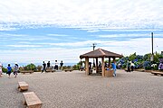 展望台
展望台 -

-


周辺
脚注
参考文献
- 徳久球雄(編集) 編『コンサイス日本山名辞典』(修訂版)三省堂、1992年10月。ISBN 4-385-15403-1。
関連項目
外部リンク
Text is available under the CC BY-SA 4.0 license; additional terms may apply.
Images, videos and audio are available under their respective licenses.
Cover photo is available under {{::mainImage.info.license.name || 'Unknown'}} license.
Cover photo is available under {{::mainImage.info.license.name || 'Unknown'}} license.
Credit:
(see original file).
