モロンダバ
モロンダバ Morondava | |
|---|---|
|
都市 | |
 | |
| 座標:南緯20度17分5秒 東経44度19分3秒 / 南緯20.28472度 東経44.31750度 | |
| 国 |
|
| 州 | トゥリアラ州 |
| 標高 coastal | 8 m |
| 人口 (2018年)[1] | |
| • 合計 | 53,510人 |
| 等時帯 | UTC+3 (東アフリカ時間) |
| 気候 | ステップ気候 |
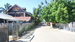
モロンダバあるいはムルンダヴァ[2](Morondava)は、マダガスカル中南西部、モザンビーク海峡に臨む都市である。人口5万3510人(2018年)。マダガスカル西部海岸、トリアリー北方およそ340kmに位置する。トゥリアラ州に属し、メナベ地域圏の州都。製材や稲作が盛んであり、農産物の積出港がある。
マダガスカル航空がモロンダバへと定期便を就航させている。街の道路の舗装率は30%未満で路面状況も悪いため、特に雨季には道路交通が非常に困難になる。人や物資の輸送には海岸沿いに丸木舟が現在でも多く使用されており、特にムルンベとの間でよく使用される。
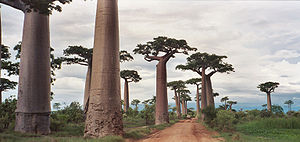
モロンダバの近くには、バオバブの並木道として知られるバオバブ群生地があり、モロンダバ観光の目玉となっている。かつてこの地には熱帯雨林が広がっていたが、人口増加に伴い多くが切り倒された。その際信仰の対象となっていたバオバブは切り倒されずに残ったため、このような光景が生まれた。
モロンダバから北に150kmのところには世界遺産であるツィンギ・デ・ベマラ厳正自然保護区が広がっており、また南には世界最小のピグミーネズミキツネザルをはじめ、8種のキツネザルの生息地であるキリンディーミテア国立公園があり、モロンダバはいわば観光の中継点となっている。ただし路面状況はおおむね悪く、到達には時間がかかる。
気候
[編集]| Morondavaの気候 | |||||||||||||
|---|---|---|---|---|---|---|---|---|---|---|---|---|---|
| 月 | 1月 | 2月 | 3月 | 4月 | 5月 | 6月 | 7月 | 8月 | 9月 | 10月 | 11月 | 12月 | 年 |
| 平均最高気温 °C (°F) | 31.9 (89.4) |
31.8 (89.2) |
32.2 (90) |
31.8 (89.2) |
30.4 (86.7) |
29.0 (84.2) |
28.7 (83.7) |
29.1 (84.4) |
29.7 (85.5) |
30.7 (87.3) |
31.6 (88.9) |
31.9 (89.4) |
30.7 (87.3) |
| 日平均気温 °C (°F) | 27.4 (81.3) |
27.2 (81) |
27.1 (80.8) |
25.8 (78.4) |
23.2 (73.8) |
21.2 (70.2) |
21.0 (69.8) |
21.9 (71.4) |
23.5 (74.3) |
25.3 (77.5) |
26.6 (79.9) |
27.3 (81.1) |
24.8 (76.6) |
| 平均最低気温 °C (°F) | 23.4 (74.1) |
23.2 (73.8) |
22.6 (72.7) |
20.5 (68.9) |
17.0 (62.6) |
14.5 (58.1) |
14.3 (57.7) |
15.3 (59.5) |
17.6 (63.7) |
20.1 (68.2) |
21.6 (70.9) |
22.9 (73.2) |
19.4 (66.9) |
| 雨量 mm (inch) | 241.6 (9.512) |
200.0 (7.874) |
89.5 (3.524) |
14.8 (0.583) |
11.4 (0.449) |
2.4 (0.094) |
2.3 (0.091) |
2.2 (0.087) |
3.6 (0.142) |
11.9 (0.469) |
20.6 (0.811) |
163.3 (6.429) |
763.6 (30.063) |
| 平均降水日数 (≥1.0 mm) | 11 | 10 | 6 | 1 | 1 | 1 | 1 | 1 | 1 | 1 | 2 | 8 | 44 |
| 平均月間日照時間 | 269.3 | 241.6 | 287.8 | 290.0 | 302.5 | 289.4 | 297.6 | 310.0 | 298.1 | 322.1 | 313.2 | 283.4 | 3,505 |
| 出典:NOAA[3] | |||||||||||||
脚注
[編集]- ^ “City Population”. 18 Apr 2023閲覧。
- ^ 湯浅, 浩史『世界の不思議な植物: 厳しい環境で生きる』誠文堂新光社、2008年、25-7頁。ISBN 978-4-416-20801-4。
- ^ “Morondava Climate Normals 1961–1990”. National Oceanic and Atmospheric Administration. October 19, 2015閲覧。
外部リンク
[編集]| 全般 | |
|---|---|
| 国立図書館 | |
| その他 | |
Text is available under the CC BY-SA 4.0 license; additional terms may apply.
Images, videos and audio are available under their respective licenses.


