For faster navigation, this Iframe is preloading the Wikiwand page for ムトワラ州.

ムトワラ州

ムトワラ州

Mkoa wa Mtwara
Mtwara Region
タンザニアの旗 タンザニア
州都 ムトワラ
面積
 • 合計 16,710 km2
人口
(2012年)
 • 合計 1,270,854人
 • 密度 76人/km2
等時帯 UTC+3 (EAT)
ISO 3166コード TZ-17

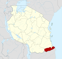
ムトワラ州(ムトワラしゅう、Mkoa wa Mtwara)は、タンザニア南東部のである。人口1,128,523人(2002年)、州都はモザンビーク国境に近い海辺の都市ムトワラである。

隣接州

[編集]

北部にリンディ州、西部にルヴマ州、南部にロヴマ川を挟んでモザンビークカボ・デルガード州ニアサ州と接している。東部はインド洋が広がる。北方のリンディ州も元々はムトワラ州の区域であったが、分かれたためにこの州はかなり小さくなってしまった。

下位行政区画

[編集]

脚注

[編集]

関連項目

[編集]


{{bottomLinkPreText}} {{bottomLinkText}}
ムトワラ州
Listen to this article

This browser is not supported by Wikiwand :(
Wikiwand requires a browser with modern capabilities in order to provide you with the best reading experience.
Please download and use one of the following browsers:

This article was just edited, click to reload
This article has been deleted on Wikipedia (Why?)

Back to homepage

Please click Add in the dialog above
Please click Allow in the top-left corner,
then click Install Now in the dialog
Please click Open in the download dialog,
then click Install
Please click the "Downloads" icon in the Safari toolbar, open the first download in the list,
then click Install
{{::$root.activation.text}}

Install Wikiwand

Install on Chrome Install on Firefox
Don't forget to rate us

Tell your friends about Wikiwand!

Gmail Facebook Twitter Link

Enjoying Wikiwand?

Tell your friends and spread the love:
Share on Gmail Share on Facebook Share on Twitter Share on Buffer

Our magic isn't perfect

You can help our automatic cover photo selection by reporting an unsuitable photo.

This photo is visually disturbing This photo is not a good choice

Thank you for helping!


Your input will affect cover photo selection, along with input from other users.

X

Get ready for Wikiwand 2.0 🎉! the new version arrives on September 1st! Don't want to wait?