ポンティーダ
| ポンティーダ Pontida | |
|---|---|
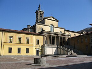
 ポンティーダ修道院 (Abbazia di Pontida) | |
| 行政 | |
| 国 |
|
| 州 |
|
| 県/大都市 |
|
| CAP(郵便番号) | 24030 |
| 市外局番 | 035 |
| ISTATコード | 016171 |
| 識別コード | G864 |
| 分離集落 | #分離集落参照 |
| 隣接コムーネ | #隣接コムーネ参照 |
| 公式サイト | リンク |
| 人口 | |
| 人口 | 3,320 [1] 人 (2021-01-01) |
| 人口密度 | 327.4 人/km2 |
| 文化 | |
| 住民の呼称 | pontidesi |
| 守護聖人 | 聖ジャコモ (San Giacomo) |
| 祝祭日 | 7月25日 |
| 地理 | |
| 座標 | 北緯45度44分02.42秒 東経09度30分23.18秒 / 北緯45.7340056度 東経9.5064389度座標: 北緯45度44分02.42秒 東経09度30分23.18秒 / 北緯45.7340056度 東経9.5064389度 |
| 標高 | 310 (197 - 710) [2] m |
| 面積 | 10.14 [3] km2 |
 | |
ポンティーダ(伊: Pontida (![]() 音声ファイル))は、イタリア共和国ロンバルディア州ベルガモ県にある、人口約3,300人の基礎自治体(コムーネ)。
音声ファイル))は、イタリア共和国ロンバルディア州ベルガモ県にある、人口約3,300人の基礎自治体(コムーネ)。
1167年、当地の修道院 (it:Abbazia di Pontida) でポンティーダの誓約 (it:Giuramento di Pontida) が結ばれ、ロンバルディア同盟が結成された。
地理
[編集]位置・広がり
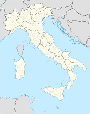
[編集]ベルガモ県西部、ヴァッレ・サン・マルティノのコムーネ。県都ベルガモから西北西へ14km、レッコから南南東へ16km、州都ミラノから北東へ38kmの距離[4]。
隣接コムーネ
[編集]隣接するコムーネは以下の通り。括弧内のLCはレッコ県所属を示す。
- アンビーヴェレ
- ブリーヴィオ (LC)
- カルコ (LC)
- カプリーノ・ベルガマスコ
- カルヴィコ
- チザーノ・ベルガマスコ
- パラッツァーゴ
- ソット・イル・モンテ・ジョヴァンニ・ヴェンティトレージモ
- ヴィッラ・ダッダ
気候分類・地震分類
[編集]気候分類では、zona E, 2510 GGに分類される[5]。 また、イタリアの地震リスク階級 (it) では、zona 3 (sismicità bassa) に分類される[6]。
行政
[編集]分離集落
[編集]ポンティーダには、以下の分離集落(フラツィオーネ)がある。
- Riviera, Valmora, Odiago
山岳部共同体
[編集]レッコ県とベルガモ県にまたがる広域行政組織である山岳部共同体「ラーリオ・オリエターレ=ヴァッレ・サン・マルティノ山岳部共同体」 (it:Comunità montana Lario Orientale - Valle San Martino) (事務所所在地: レッコ県ガルビアーテ)を構成するコムーネである。
文化
[編集]イタリア統一運動とポンティーダ
[編集]ポンティーダで発足したロンバルディア同盟は、1176年にレニャーノの戦いで神聖ローマ帝国軍を打ち破った。このことから、近代のイタリア統一運動(リソルジメント)の中で、ポンティーダの地名はイタリア人の団結と結びつけて言及される。
人口動態
[編集]
脚注
[編集]- ^ 国立統計研究所(ISTAT). “Resident population on 1st January : Lombardia” (英語). 2021年5月10日閲覧。左側メニューのPopulation and Households > Population > Resident population on 1st January > Regions and municipalities より州を選択
- ^ 国立統計研究所(ISTAT). “Tavola: Popolazione residente - Bergamo (dettaglio loc. abitate) - Censimento 2001.” (イタリア語). 2017年9月5日閲覧。
- ^ 国立統計研究所(ISTAT). “Tavola: Superficie territoriale (Kmq) - Bergamo (dettaglio comunale) - Censimento 2001.” (イタリア語). 2017年9月5日閲覧。
- ^ “地図上で2地点の方角・方位、距離を調べる”. 2017年1月6日閲覧。
- ^ “Tabella dei gradi/giorno dei Comuni italiani raggruppati per Regione e Provincia”. 新技術エネルギー環境局(ENEA) (2011年3月1日). 2017年1月1日時点のオリジナルよりアーカイブ。2020年9月20日閲覧。
- ^ “Classificazione sismica - Aggiornata ad aprile 2021.” (xls). https://rischi.protezionecivile.gov.it/it/sismico/attivita/classificazione-sismica. イタリア市民保護局. 2021年9月9日閲覧。
外部リンク
[編集]Text is available under the CC BY-SA 4.0 license; additional terms may apply.
Images, videos and audio are available under their respective licenses.


