フェラーラ県
- フェラーラ県
- Provincia di Ferrara
-
フェラーラの県章 
-
国  イタリア
イタリア
州  エミリア=ロマーニャ
県都 フェラーラ 面積 2,631.12 [1] km² 人口
- 総計
- 人口密度2023-01-01 [2]
339287 人
129 人/km²コムーネ数 21 (50音順一覧) 主なコムーネ アルジェンタ、ボンデーノ、チェント、コディゴーロ、コマッキオ、コッパーロ、ポルトマッジョーレ 略記号 FE ISO 3166-2:IT IT-FE CAP 44121-44124 (Ferrara),44010-44049 (Provincia) 市外局番 0532, 0533 ISTATコード 038 県公式ウェブサイト [1]


フェラーラ県(フェラーラけん、イタリア語: Provincia di Ferrara)は、イタリア共和国エミリア=ロマーニャ州に属する県。県都はフェラーラ(フェッラーラ)。「フェッラーラ県」とも表記される。
地理
[編集]位置・広がり
[編集]フェラーラ県はエミリア=ロマーニャ州北東部に位置する。東西に細長い県で、東はアドリア海に面し、北はポー川を挟んでヴェネト州と接する。伝統的な地域分けではエミリア地方 (it:Emilia) 東部で、その沿海部にあたる。
県都フェラーラは県域の中央やや西寄りに位置しており、州都ボローニャから北東へ44km、ヴェネツィアから南西へ87km、フィレンツェから北北東へ122km、首都ローマから北北西へ337kmの距離にある[3]。
隣接する県は以下の通り。
地勢
[編集]フェラーラ県は、ポー川下流の右岸(南岸)に広がっており、ポー川デルタ地帯 (it:Delta del Po) の主要部を占める。地勢は平坦であり、最高地点は海抜22mである(ポッジョ・レナーティコの町域)。県東部のアドリア海沿岸部には、コマッキオ潟 (it:Valli di Comacchio) などの潟湖がいくつもある。
北のヴェネト州との境界は、西側3分の2がポー川本流、残り3分の1が「ポー川5大支流」の1つ、ポー・ディ・ゴーロ川 (it:Po di Goro) である。県域の中央部を、ポー川5大支流の1つ、ポー・ディ・ヴォラーノ川 (it:Po di Volano) が県域の中央を西から東に流れる。
南西のボローニャ県、南のラヴェンナ県との境界はレーノ川 (it:Reno (Italia)) が流れる。
-
 ポー川デルタ地帯
 -
 コマッキオ潟


県内の地域と主要な都市
[編集]2001年の国勢調査に基づく居住地区(Località abitata)別人口統計[4]によれば、人口5000人以上の都市・集落は以下の通り。
- フェラーラ - 94,307人
- チェント - 14,720人
- コッパーロ - 9,038人
- コマッキオ - 8,299人
- ボンデーノ - 7,618人
- ポルトマッジョーレ - 6,929人
- コディゴーロ - 6,815人
- アルジェンタ - 6,792人
最多の人口を持つのは県都フェラーラである。県西部のチェントがこれに次ぐ。フェラーラの市街は、ポー川デルタ地帯とともに「フェラーラ:ルネサンス期の市街とポー川デルタ地帯」として、ユネスコの世界遺産に登録されている。
県東部のアドリア海沿岸部にはコマッキオなどの町がある。
-
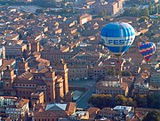 フェラーラ
フェラーラ -
 コッパーロ
コッパーロ -
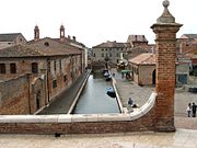 コマッキオ
コマッキオ

.JPG)

行政区画
[編集]コムーネ
[編集]フェラーラ県には21のコムーネが属する。主要なコムーネ(人口1万人以上)は下表の通り。左端の数字はISTATコードを示す。人口は2019年1月1日現在[2]。それ以外のコムーネ、および面積等の詳細なデータは「全コムーネ一覧」参照のこと。
右の地図中の番号は、コムーネのISTATコード下3桁を示す。
.svg)
| コード | 自治体名 | 人口 |
|---|---|---|
| 038008 | フェラーラ | 129,724 |
| 038004 | チェント | 35,291 |
| 038006 | コマッキオ | 22,047 |
| 038001 | アルジェンタ | 20,958 |
| 038007 | コッパーロ | 15,694 |
| 038003 | ボンデーノ | 13,821 |
| 038019 | ポルトマッジョーレ | 11,806 |
| 038005 | コディゴーロ | 11,073 |
左端の数字はISTATコードを示す。人口は2023年1月1日現在[2]。面積は2001年のデータで[1]、単位はkm²。
| 自治体名 | 綴り | 面積 | 人口 | |
|---|---|---|---|---|
| 038001 | アルジェンタ | Argenta | 311.02 | 20,958 |
| 038003 | ボンデーノ | Bondeno | 175.17 | 13,821 |
| 038004 | チェント | Cento | 64.77 | 35,291 |
| 038005 | コディゴーロ | Codigoro | 169.79 | 11,073 |
| 038006 | コマッキオ | Comacchio | 283.77 | 22,047 |
| 038007 | コッパーロ | Copparo | 157.00 | 15,694 |
| 038008 | フェラーラ | Ferrara | 404.26 | 129,724 |
| 038010 | ヨランダ・ディ・サヴォーイア | Jolanda di Savoia | 108.09 | 2,636 |
| 038011 | ラゴザント | Lagosanto | 34.23 | 4,720 |
| 038012 | マージ・トレッロ | Masi Torello | 22.92 | 2,293 |
| 038014 | メゾーラ | Mesola | 84.25 | 6,459 |
| 038017 | オステッラート | Ostellato | 173.70 | 5,617 |
| 038018 | ポッジョ・レナーティコ | Poggio Renatico | 79.79 | 9,721 |
| 038019 | ポルトマッジョーレ | Portomaggiore | 126.40 | 11,806 |
| 038022 | ヴィガラーノ・マイナルダ | Vigarano Mainarda | 42.28 | 7,625 |
| 038023 | ヴォギエーラ | Voghiera | 40.51 | 3,562 |
| 038025 | ゴーロ | Goro | 31.38 | 3,481 |
| 038027 | フィスカッリア | Fiscaglia | 115.57 | 8,403 |
| 038028 | テッレ・デル・レーノ | Massa Fiscaglia | 51.45 | 9,991 |
| 038029 | リーヴァ・デル・ポー | Riva del Po | 111.65 | 7,403 |
| 038030 | トレジニャーナ | Tresignana | 43.12 | 6,962 |
21世紀に入って以降、以下のコムーネ統廃合 (it:Fusione di comuni italiani) が行われている。
- 2014年発足
- 2017年発足
- テッレ・デル・レーノ(ミラベッロ、サンタゴスティーノが合併)
- 2019年発足
文化・観光
[編集]世界遺産
[編集]- フェラーラ:ルネサンス期の市街とポー川デルタ地帯
交通
[編集]道路
[編集]おおむね北および西を優先し、通過点もしくはその近傍の地名を示す。〔 〕内は県外。
- E55号線 : SS309
- 〔… - ヴェネツィア〕 - コマッキオ - 〔ラヴェンナ - …〕
- アウトストラーダ A13
- ラッコルド・アウトストラダーレ RA8
- フェラーラ南 - ミリアリーノ - ポルト・ガリバルディ (it:Porto Garibaldi) (コマッキオ)
- おもな国道
- SS16 (it:Strada statale 16 Adriatica)
- SS64 (it:Strada statale 64 Porrettana)
- フェラーラ - 〔ボローニャ - ピストイア〕
- SS309 (it:Strada statale 309 Romea)
- 〔ヴェネツィア〕 - コマッキオ - 〔ラヴェンナ〕
鉄道
[編集]
- パドヴァ=ボローニャ線 (it:Ferrovia Padova-Bologna)
- フェラーラ=リミニ線 (it:Ferrovia Ferrara-Rimini)
- スザッラ=フェラーラ線 (it:Ferrovia Suzzara-Ferrara)
- フェラーラ=コディゴーロ線 (it:Ferrovia Ferrara-Codigoro)
- ボローニャ=ポルトマッジョーレ線 (it:Ferrovia Bologna-Portomaggiore)
港湾
[編集]- ポルト・ガリバルディ (it:Porto Garibaldi)
空港
[編集]- フェラーラ=サンルカ空港 (it:Aeroporto di Ferrara-San Luca)
人物
[編集]君主については「フェラーラとモデナの君主一覧」も参照のこと。
著名な出身者
[編集]- ジローラモ・サヴォナローラ - 15世紀の宗教家。フェラーラ生まれ。
- ジローラモ・フレスコバルディ - 17世紀、初期バロック音楽の作曲家。フェラーラ生まれ。
- グエルチーノ - 16世紀の画家。チェント生まれ。
- ジョヴァンニ・バッティスタ・リッチョーリ - 17世紀の天文学者。フェラーラ生まれ。
- イタロ・バルボ - 20世紀の軍人・政治家。「ファシスト四天王」の一人。フェラーラ生まれ。
- フェルッチオ・ランボルギーニ - 20世紀の実業家、ランボルギーニ創業者。チェント生まれ。
脚注
[編集]- ^ a b 国立統計研究所(ISTAT). “Tavola: Superficie territoriale (Kmq) - Ferrara (dettaglio comunale) - Censimento 2001.” (イタリア語). 2012年7月9日閲覧。
- ^ a b c “Popolazione residente per sesso, età e stato civile al 1° gennaio 2023” (イタリア語). 国立統計研究所(ISTAT). 2024年3月6日閲覧。メニューでVista per singola areaを選択。Anno:2023, Ripartizione:Nord-est, Regione:Emilia-Romagna, Provincia:Ferrara, Comune:- を選択
- ^ “2点間の直線距離を測る”. 2014年7月20日閲覧。
- ^ 国立統計研究所(ISTAT). “Tavola: Popolazione residente - Ferrara (dettaglio loc. abitate) - Censimento 2001.” (イタリア語). 2012年7月9日閲覧。
外部リンク
[編集]
|
マントヴァ県(ロンバルディア州) | ロヴィーゴ県(ヴェネト州) |
| |
| モデナ県 | ||||
| ボローニャ県 | ラヴェンナ県 |
| 全般 | |
|---|---|
| 国立図書館 | |
| 地理 | |
| その他 | |
Text is available under the CC BY-SA 4.0 license; additional terms may apply.
Images, videos and audio are available under their respective licenses.
