For faster navigation, this Iframe is preloading the Wikiwand page for ファイル:Watson Brake Mounds - Map.png.

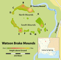
ファイル:Watson Brake Mounds - Map.png

元のファイル(1,509 × 1,484 ピクセル、ファイルサイズ: 297キロバイト、MIME タイプ: image/png)

解説
Deutsch: Karte: Übersicht über die archäologische Stätte von Watson Brake (Louisiana)
English: Map of the Watson Brake archaeological site
日付 see file history
原典

Self made, using

  • Joe W. Saunders, Rolfe D. Mandel, et al.: Watson Brake, a Middle Archaic Mound Complex in Northeast Louisiana. In: American Antiquity, Vol. 70, No. 4 (Oktober 2005), pages 631-668 [634]
  • this orientation map by Alexrk2
作者 Maximilian Dörrbecker (Chumwa)
許可
(ファイルの再利用)
この作品の著作権者である私は、この作品を以下のライセンスで提供します。
w:ja:クリエイティブ・コモンズ
表示 継承
このファイルはクリエイティブ・コモンズ 表示-継承 2.5 一般ライセンスのもとに利用を許諾されています。
あなたは以下の条件に従う場合に限り、自由に
  • 共有 – 本作品を複製、頒布、展示、実演できます。
  • 再構成 – 二次的著作物を作成できます。
あなたの従うべき条件は以下の通りです。
  • 表示 – あなたは適切なクレジットを表示し、ライセンスへのリンクを提供し、変更があったらその旨を示さなければなりません。これらは合理的であればどのような方法で行っても構いませんが、許諾者があなたやあなたの利用行為を支持していると示唆するような方法は除きます。
  • 継承 – もしあなたがこの作品をリミックスしたり、改変したり、加工した場合には、あなたはあなたの貢献部分を元の作品とこれと同一または互換性があるライセンスの下に頒布しなければなりません。

Sie dürfen das Bild zu den folgenden Bedingungen nutzen:

  • Sie müssen den Namen des Autors nennen.
  • Im Falle einer Verbreitung müssen Sie anderen die Lizenzbedingungen, unter die dieses Bild fällt, mitteilen.
  • Sie müssen das Bild unter gleichen Bedingungen weitergeben. Wenn sie das Bild abändern oder Arbeiten auf diesem Bild aufbauen, müssen Sie das Ergebnis aus dieser Arbeit ebenfalls unter diese Lizenz stellen.
  • Jede dieser Bedingungen kann nach schriftlicher Einwilligung des Rechtsinhabers aufgehoben werden.
 
その他のバージョン
Open this image as an overlay in Google Earth (Google Maps, Bing) (Help|Source)

キャプション

このファイルの内容を1行で記述してください

このファイルに描写されている項目

題材

ファイルの履歴

過去の版のファイルを表示するには、その版の日時をクリックしてください。

日付と時刻サムネイル寸法利用者コメント
現在の版2011年4月21日 (木) 19:092011年4月21日 (木) 19:09時点における版のサムネイル1,509 × 1,484 (297キロバイト)Chumwacorr
2011年4月18日 (月) 21:012011年4月18日 (月) 21:01時点における版のサムネイル1,509 × 1,484 (295キロバイト)Chumwa((Information |Description= *(( de )) Karte: Übersicht über die archäologische Stätte von Watson Brake (Louisiana) *(( en )) Map of the Watson Brake archaeological site |Source=Self made, using [[:Image:USA Louisiana location map.svg|this orientation

ファイルの使用状況

以下のページがこのファイルを使用しています:

グローバルなファイル使用状況

以下に挙げる他のウィキがこの画像を使っています:

{{bottomLinkPreText}} {{bottomLinkText}}
ファイル:Watson Brake Mounds - Map.png
Listen to this article

This browser is not supported by Wikiwand :(
Wikiwand requires a browser with modern capabilities in order to provide you with the best reading experience.
Please download and use one of the following browsers:

This article was just edited, click to reload
This article has been deleted on Wikipedia (Why?)

Back to homepage

Please click Add in the dialog above
Please click Allow in the top-left corner,
then click Install Now in the dialog
Please click Open in the download dialog,
then click Install
Please click the "Downloads" icon in the Safari toolbar, open the first download in the list,
then click Install
{{::$root.activation.text}}

Install Wikiwand

Install on Chrome Install on Firefox
Don't forget to rate us

Tell your friends about Wikiwand!

Gmail Facebook Twitter Link

Enjoying Wikiwand?

Tell your friends and spread the love:
Share on Gmail Share on Facebook Share on Twitter Share on Buffer

Our magic isn't perfect

You can help our automatic cover photo selection by reporting an unsuitable photo.

This photo is visually disturbing This photo is not a good choice

Thank you for helping!


Your input will affect cover photo selection, along with input from other users.

X

Get ready for Wikiwand 2.0 🎉! the new version arrives on September 1st! Don't want to wait?