For faster navigation, this Iframe is preloading the Wikiwand page for ファイル:Orbits around earth scale diagram.svg.

ファイル:Orbits around earth scale diagram.svg

元のファイル(SVG ファイル、4,300 × 4,300 ピクセル、ファイルサイズ: 5キロバイト)

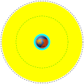
English Deutsch Français తెలుగు Marker Distance above earth (km) Distance from center of earth (km)
Earth Erde Terre భూమి Blue/brown image 0 6370
Low Earth Orbit (LEO) Low Earth Orbit Orbite terrestre basse భూ నిమ్న కక్ష్య Cyan area 160 to 2,000 6,530 to 8,370
Medium Earth Orbit (MEO) Medium Earth Orbit Orbite moyenne de la terre భూ మధ్యస్థ కక్ష్య Yellow area 2,000 to 34,780 8,370 to 41,150
International Space Station (ISS) Internationale Raumstation Station spatiale internationale అంతర్జాతీయ అంతరిక్ష కేంద్రం Red dotted line 370 6,741
Global Positioning System (GPS) satellites Globales Positionsbestimmungssystem Système de positionnement mondial గ్లోబల్ పొజిషనింగ్ వ్యవస్థ Green dash-dot line 20,230 26,600
Geostationary Orbit (GEO) Geostationäre Umlaufbahn Orbite géostationnaire భూ స్థిర కక్ష్య Black dashed line 35,794 42,164


解説
English: A scale diagram showing earth and various orbits above it.
Deutsch: Skalendiagramm der Erde und verschiedener Umlaufbahnen.
Français : Diagramme échelle montrant la terre et des orbites.
తెలుగు: భూమిని, భూ కక్ష్యలను చూపే ప్రామాణిక చిత్రం.
日付
原典 Created by Commons user Mike1024, Earth based on File:Worldmap northern.svg
作者 Image of earth: Gringer. Scale orbits: Mike1024
許可
(ファイルの再利用)

This image is based on a public domain image (File:Worldmap northern.svg) and is released into the public domain.

Public domain この著作物の著作権者である私は、この著作物における権利を放棄しパブリックドメインとします。これは全世界で適用されます。
一部の国では、これが法的に可能ではない場合があります。その場合は、次のように宣言します。
私は、あらゆる人に対して、法により必要とされている条件を除き、如何なる条件も課すことなく、あらゆる目的のためにこの著作物を使用する権利を与えます。

12121

キャプション

このファイルの内容を1行で記述してください

このファイルに描写されている項目

題材

16 1 2008

ファイルの履歴

過去の版のファイルを表示するには、その版の日時をクリックしてください。

日付と時刻サムネイル寸法利用者コメント
現在の版2014年3月30日 (日) 19:062014年3月30日 (日) 19:06時点における版のサムネイル4,300 × 4,300 (5キロバイト)XZisefixed rotation of Earth (is now looking from above)
2014年3月30日 (日) 15:272014年3月30日 (日) 15:27時点における版のサムネイル4,300 × 4,300 (3キロバイト)XZisemanually rewritten from scratch thus dramatically reduced file size
2008年1月16日 (水) 23:192008年1月16日 (水) 23:19時点における版のサムネイル3,009 × 3,009 (19キロバイト)Mike1024{| class="wikitable" style="text-align:center" |- ! English !! Deutsch !! Français !! Marker !! Distance above earth (km) |!!Distance from center of earth (km) |- ! Earth !! Erde !! Terre | Blue/brown image || 0 |

ファイルの使用状況

以下の​ 4 ページがこのファイルを使用しています:

グローバルなファイル使用状況

以下に挙げる他のウィキがこの画像を使っています:

このファイルのグローバル使用状況を表示する。

メタデータ

{{bottomLinkPreText}} {{bottomLinkText}}
ファイル:Orbits around earth scale diagram.svg
Listen to this article

This browser is not supported by Wikiwand :(
Wikiwand requires a browser with modern capabilities in order to provide you with the best reading experience.
Please download and use one of the following browsers:

This article was just edited, click to reload
This article has been deleted on Wikipedia (Why?)

Back to homepage

Please click Add in the dialog above
Please click Allow in the top-left corner,
then click Install Now in the dialog
Please click Open in the download dialog,
then click Install
Please click the "Downloads" icon in the Safari toolbar, open the first download in the list,
then click Install
{{::$root.activation.text}}

Install Wikiwand

Install on Chrome Install on Firefox
Don't forget to rate us

Tell your friends about Wikiwand!

Gmail Facebook Twitter Link

Enjoying Wikiwand?

Tell your friends and spread the love:
Share on Gmail Share on Facebook Share on Twitter Share on Buffer

Our magic isn't perfect

You can help our automatic cover photo selection by reporting an unsuitable photo.

This photo is visually disturbing This photo is not a good choice

Thank you for helping!


Your input will affect cover photo selection, along with input from other users.

X

Get ready for Wikiwand 2.0 🎉! the new version arrives on September 1st! Don't want to wait?