ファイル:Lage des Landkreises Bayreuth in Deutschland.png
高解像度版はありません。
Lage_des_Landkreises_Bayreuth_in_Deutschland.png (197 × 235 ピクセル、ファイルサイズ: 3キロバイト、MIME タイプ: image/png)
ウィキメディア・コモンズのファイルページにある説明を、以下に表示します。
|
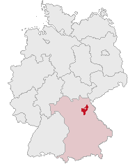
| 解説 | Landkreis Bayreuth, Bavaria, Germany | ||||||||
| 日付 | |||||||||
| 原典 | 投稿者自身による著作物 | ||||||||
| 作者 | own work by Geograv | ||||||||
| 許可 (ファイルの再利用) |
|

ファイルの履歴
過去の版のファイルを表示するには、その版の日時をクリックしてください。
| 日付と時刻 | サムネイル | 寸法 | 利用者 | コメント | |
|---|---|---|---|---|---|
| 現在の版 | 2008年5月28日 (水) 23:14 | | 197 × 235 (3キロバイト) | Rauenstein | ((Information |Description=Landkreis Bayreuth, Bavaria, Germany |Source=self |Date=2008-05-29 |Author=own work by Geograv |Permission= ((GFDL)) )) Bayreuth [[Ca |
ファイルの使用状況
以下の 34 ページがこのファイルを使用しています:
- アウフゼス
- アホルンタール
- エッカースドルフ
- エムトマンスベルク
- キルヒェンピンガルテン
- クロイセン
- グラースヒュッテン (オーバーフランケン)
- ゲゼース
- ゲフレース
- ゴルトクローナハ
- ザイボーテンロイト
- シュナーベルヴァイト
- シュパイヒャースドルフ
- ハイナースロイト
- ハーク (オーバーフランケン)
- バイロイト郡
- バート・ベルネック・イム・フィヒテルゲビルゲ
- ビショフスグリュン
- ビントラハ
- フィヒテルベルク (オーバーフランケン)
- フンメルタール
- プランケンフェルス
- プレヒ
- プレビッツ
- ベッツェンシュタイン
- ペグニッツ
- ホルフェルト
- ポッテンシュタイン (オーバーフランケン)
- ミステルガウ
- ミステルバッハ (オーバーフランケン)
- メールマイゼル
- ヴァイシェンフェルト
- ヴァイデンベルク
- ヴァルメンシュタイナハ
グローバルなファイル使用状況
以下に挙げる他のウィキがこの画像を使っています:
- da.wikipedia.org での使用状況
- de.wikipedia.org での使用状況
- fr.wikipedia.org での使用状況
- pl.wikipedia.org での使用状況
Text is available under the CC BY-SA 4.0 license; additional terms may apply.
Images, videos and audio are available under their respective licenses.
Cover photo is available under {{::mainImage.info.license.name || 'Unknown'}} license.
Cover photo is available under {{::mainImage.info.license.name || 'Unknown'}} license.
Credit:
(see original file).
