ファイル:Harz map.png
このプレビューのサイズ: 800 × 482 ピクセル。 その他の解像度: 320 × 193 ピクセル | 640 × 385 ピクセル | 1,024 × 617 ピクセル | 1,280 × 771 ピクセル | 2,529 × 1,523 ピクセル。
元のファイル (2,529 × 1,523 ピクセル、ファイルサイズ: 3.15メガバイト、MIME タイプ: image/png)
ウィキメディア・コモンズのファイルページにある説明を、以下に表示します。
|
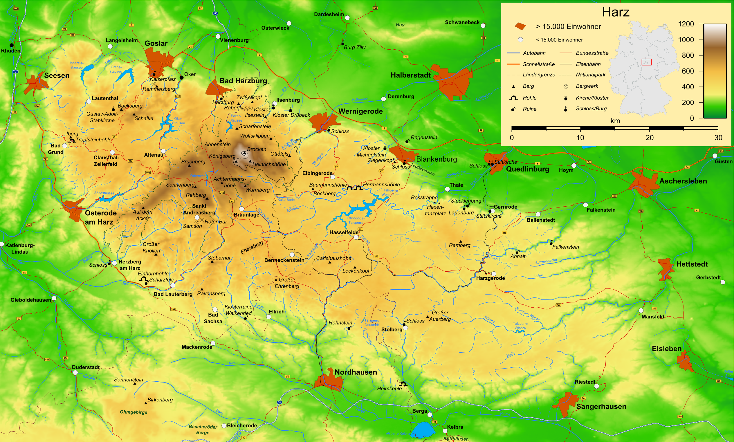
概要
| 解説 | Map of the Harz mountains in Germany with mountains, rivers, lakes, reservoirs, all highways, all Bundesstraßen, Harzquerbahn, Brockenbahn, Selketalbahn, major towns and sights. |
| 日付 | |
| 原典 | 投稿者自身による著作物 |
| 作者 | Bamse |
| その他のバージョン |
このファイルの派生的著作物: Karte Harzer Schmalspurbahnen.png  , ,  , ,  |
|
|

|
この文書は、フリーソフトウェア財団発行のGNUフリー文書利用許諾書 (GNU Free Documentation License) 1.2またはそれ以降のバージョンの規約に基づき、複製や再配布、改変が許可されます。不可変更部分、表紙、背表紙はありません。このライセンスの複製は、GNUフリー文書利用許諾書という章に含まれています。 |
| このファイルはクリエイティブ・コモンズ 表示-継承 3.0 非移植ライセンスのもとに利用を許諾されています。 | ||
| ||
| このライセンスのテンプレートは、GFDLのライセンス・アップデートによりこのファイルに追加されたものです。 |

|
この地図は、ドイツ語版の(地図研究室)で制作、もしくは改善されたものです。更なる改善の為、地図を提案することもできます。
|
ファイルの履歴
過去の版のファイルを表示するには、その版の日時をクリックしてください。
| 日付と時刻 | サムネイル | 寸法 | 利用者 | コメント | |
|---|---|---|---|---|---|
| 現在の版 | 2009年12月15日 (火) 16:05 | | 2,529 × 1,523 (3.15メガバイト) | Bamse | update, B6n is completed |
| 2007年12月14日 (金) 06:12 |  | 2,529 × 1,523 (3.15メガバイト) | Bamse | ((Information |Description=Map of the Harz mountains in Germany with mountains, rivers, lakes, reservoirs, all highways, all Bundesstraßen, Harzquerbahn, Brockenbahn, [[:w:Selketalba | |
| 2007年9月19日 (水) 05:10 |  | 2,529 × 1,523 (3.14メガバイト) | Bamse | ||
| 2007年9月19日 (水) 02:33 |  | 2,529 × 1,523 (3.13メガバイト) | Bamse | ((Information |Description=Map of the w:Harz mountains in Germany. |Source=self-made |Date=19-09-2007 |Author= Bamse )) ((GFDL-GMT)) | |
| 2007年9月5日 (水) 08:21 |  | 2,529 × 1,523 (3.09メガバイト) | Bamse | ((Information |Description=Map of the w:Harz mountains in Germany. |Source=self-made |Date=05-09-2007 |Author= Bamse )) ((GFDL-GMT)) | |
| 2007年7月25日 (水) 06:02 |  | 2,532 × 1,527 (3メガバイト) | Bamse | ((Information |Description=Map of the w:Harz mountains in Germany. |Source=self-made |Date=25-07-2007 |Author= Bamse )) ((GFDL-GMT)) | |
| 2007年7月17日 (火) 10:30 |  | 2,529 × 1,526 (2.94メガバイト) | Bamse | ((Information |Description=Map of the w:Harz mountains in Germany. |Source=self-made |Date=17-07-2007 |Author= Bamse )) ((GFDL-GMT)) | |
| 2007年7月11日 (水) 11:42 |  | 2,529 × 1,523 (2.89メガバイト) | Bamse | ((Information |Description=Map of the w:Harz mountains in Germany. |Source=self-made |Date=11-07-2007 |Author= Bamse )) ((GFDL-GMT)) | |
| 2007年7月6日 (金) 10:21 |  | 2,529 × 1,523 (2.84メガバイト) | Bamse | ((Information |Description=Map of the w:Harz mountains in Germany. |Source=self-made |Date=06-07-2007 |Author= Bamse )) ((GFDL-GMT)) | |
| 2007年6月28日 (木) 02:48 |  | 2,529 × 1,523 (2.77メガバイト) | Bamse | ((Information |Description=Map of the w:Harz mountains in Germany. |Source=self-made |Date=28-06-2007 |Author= Bamse )) ((GFDL-GMT)) |
ファイルの使用状況
以下の 2 ページがこのファイルを使用しています:
グローバルなファイル使用状況
以下に挙げる他のウィキがこの画像を使っています:
- ar.wikipedia.org での使用状況
- be.wikipedia.org での使用状況
- bg.wikipedia.org での使用状況
- br.wikipedia.org での使用状況
- ca.wikipedia.org での使用状況
- de.wikipedia.org での使用状況
- Harz (Mittelgebirge)
- Harzer Hexenstieg
- Kaiserweg (Harz)
- Karstwanderweg
- Wikipedia:Kartenwerkstatt/Archiv/2007-09
- Liste von Bergen im Harz
- Wikipedia:Kandidaten für exzellente Bilder/Archiv2007/14
- Harzklippen
- Selketalstieg
- Benutzer:Ulflulfl/Karten
- Harzer Baudensteig
- Harzer Försterstieg
- Unterharzer Teich- und Grabensystem
- Portal:Harz
- Bode-Selke-Stieg
- Oberharzer Erzgänge
- Vorlage:Navigationsleiste Regionale Wanderwege im Harz
- Harzer Grenzweg
- Liste der Moore im Harz
- Harzer Klosterwanderweg
- Kaiser-Otto-Höhenweg
- Georgi Wladimirowitsch Iwanow
- Steinway Trail
- Teufelsstieg
- Gebietstausch 1945 im Harz
- Portal:Harz/Eingangstext
- Benutzer:D.W.Germann/Liste von Poststempeln im Harz
- Benutzer:D.W.Germann/Liste der Brockenkarten
- Benutzer:D.W.Germann/Eigenes/Mediensammlung
- Benutzer:D.W.Germann/Liste der Kartenwerke des Harzes
- en.wikipedia.org での使用状況
- eo.wikipedia.org での使用状況
- fi.wikipedia.org での使用状況
- fr.wikipedia.org での使用状況
- fr.wiktionary.org での使用状況
- hu.wikipedia.org での使用状況
- incubator.wikimedia.org での使用状況
- is.wikipedia.org での使用状況
- it.wikipedia.org での使用状況
このファイルのグローバル使用状況を表示する。
Text is available under the CC BY-SA 4.0 license; additional terms may apply.
Images, videos and audio are available under their respective licenses.
Cover photo is available under {{::mainImage.info.license.name || 'Unknown'}} license.
Cover photo is available under {{::mainImage.info.license.name || 'Unknown'}} license.
Credit:
(see original file).
