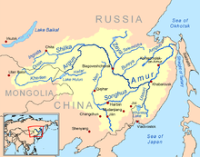
ビキン川
| ビキン川 | |
|---|---|
 ビキン川上流 | |
| 延長 | 560 km |
| 平均流量 | 246 m³/s |
| 流域面積 | 22,300 km² |
| 水源 | シホテアリニ山脈 |
| 河口・合流先 | ウスリー川 |
| 流路 | ウスリー川→アムール川→オホーツク海 |
| 流域 |
沿海州 ハバロフスク地方 |

ビキン川(ビキンがわ、ロシア語: Бики́н,英語: Bikin)は、ロシアハバロフスク地方・沿海地方を流れるウスリー川の右支流である。 清朝時代は畢歆河と呼ばれていたが、現代中国語では比金河である。
概要
[編集]水源はシホテアリニ山脈で、全長は560km、流域面積は22,300km²である 。比較的大きな支流にはアルチャン川がある。
ウスリー川との合流点付近にはビキン地区の行政の中心であるビキンが位置する。
ビキン川流域は歴史的にウデヘ人の居住地域であり、現在も中流域にはウデヘ人の集落クラースヌイ・ヤール村が存在する[1]。


参考文献
[編集]アレクサンドル・カンチュガ著、津曲敏郎訳『ビキン川のほとりで 沿海州ウデヘ人の少年時代』北海道大学出版会、2014年
脚注
[編集]- ^ 津曲2014,1頁
| アムール川本流 | ゴリン川(格楞河) - アニュイ川(敦敦河) - グル川 - トゥングースカ川 - ビラ川(奇穆尼河) - ビジャン川(畢瞻河) - ザヴィタヤ川 - フマル川(呼瑪河) - ウルシャ川(額哩河) - アマザル川(格爾必斉河) | |
|---|---|---|
| スンガリ川水系 | スンガリ川(松花江) - 牡丹江 - 呼蘭河 - 拉林河 - 阿什河 | |
| ノン川水系 | ノン川(嫩江) - ガン川(甘河) - ネメル川(訥謨爾河) - ノミン川(諾敏河) - ヤル川(雅魯河) - トール川(洮児河) - 霍林河 | |
| アルグン川水系 | ||
| ゼヤ川水系 | ゼヤ川(精奇里江) - セレムジャ川(西林穆丹河) - ギリウイ川(吉魯河) - トミ川 - デプ川(濘泥河) | |
| ブレヤ川水系 | ブレヤ川(牛満河) - ウルガル川 - ティルマ川 - ニマン川(斡倫奇河) - トゥユン川 | |
| アムグン川水系 | ||
| ウスリー川水系 | ||
Text is available under the CC BY-SA 4.0 license; additional terms may apply.
Images, videos and audio are available under their respective licenses.

